Butun axtardiqlarinizi tapmaq ucun buraya: DAXIL OLUN
  Mp4 Mp3 Axtar Yukle
  Video Axtar Yukle
  Shekil Axtar Yukle
  Informasiya Melumat Axtar
  Hazir Inshalar Toplusu
  AZERI CHAT + Tanishliq
  1-11 Sinif Derslikler Yukle
  Saglamliq Tibbi Melumat
  Whatsapp Plus Yukle(Yeni)

  • Ana səhifə
  • Təsadüfi
  • Yaxınlıqdakılar
  • Daxil ol
  • Nizamlamalar
İndi ianə et Əgər Vikipediya sizin üçün faydalıdırsa, bu gün ianə edin.

Fayl:WorldMapCosmasIndicopleustes.jpg

  • Fayl
  • Müzakirə
  • Lokal izah əlavə et
  • Fayl
  • Faylın tarixçəsi
  • Faylın istifadəsi
  • Faylın qlobal istifadəsi
  • Metaməlumatlar
Fayl:WorldMapCosmasIndicopleustes.jpg
Sınaq göstərişi ölçüsü: 764 × 600 piksel. Digər ölçülər: 306 × 240 piksel | 612 × 480 piksel | 979 × 768 piksel | 1.280 × 1.005 piksel | 1.539 × 1.208 piksel.

Faylın orijinalı (1.539 × 1.208 piksel, fayl həcmi: 654 KB, MIME növü: image/jpeg)

Bu fayl Vikianbarda yerləşir. Açıqlama səhifəsindəki məlumatlar aşağıda göstərilib.
Vikianbar azad lisenziyalı media anbarıdır. Siz də töhfə verə bilərsiniz.

Xülasə

İzahWorldMapCosmasIndicopleustes.jpg 
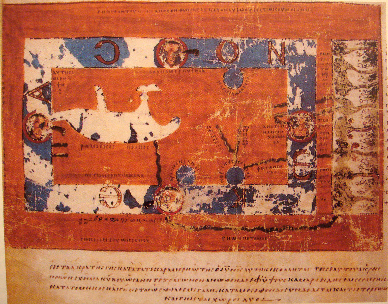
World Map by Cosmas Indicopleustes. The map is oriented with north to the top. It shows a rectangular landmass in the middle of the World Ocean (
ꙌΚΕΑΝΟϹ
, Okeanos), reflecting what Cosmas thought was the "floor" of the tabernacle-shaped universe. The Roman Gulf (i.e., Mediterranean) is shown in the western half, with indentations for the unmarked Adriatic and Aegean/Black seas. Three further gulfs are shown: the Caspian to the northeast and the Arabian (i.e., Red Sea) and Persian gulfs to the south. Paradise is shown in the far east, beyond the Ocean. Four rivers run from it and cross under or through the Ocean to reach Asia and Africa.
Tarix 6th century map.
Mənbə "Les Sciences au Moyen-Age", "Pour la Science"
Müəllif Cosmas Indicopleustes, 6th century
Digər versiyalar
  • A simplified B&W English version from the Encyclopædia Britannica, 11th ed.,'s "Map" article
    A simplified B&W English version from the Encyclopædia Britannica, 11th ed.,'s "Map" article

Lisenziya

Bu şəkil, təsviri incəsənət əsərinin orijinal ikiölçülü dəqiq fotoqrafiya reproduksiyasıdır. Təsviri incəsənətin bu əsəri öz-özlüyündə aşağıdakı səbəblərdən ictimai varidat sayılır:
Public domainPublic domainfalsefalse
Public domain

This work is in the public domain in its country of origin and other countries and areas where the copyright term is the author's life plus 70 years or fewer.


You must also include a United States public domain tag to indicate why this work is in the public domain in the United States.
 Note that a few countries have copyright terms longer than 70 years: Mexico has 100 years, Jamaica has 95 years, Colombia has 80 years, and Guatemala and Samoa have 75 years. This image may not be in the public domain in these countries, which moreover do not implement the rule of the shorter term. Honduras has a general copyright term of 75 years, but it does implement the rule of the shorter term. Copyright may extend on works created by French who died for France in World War II (more information), Russians who served in the Eastern Front of World War II (known as the Great Patriotic War in Russia) and posthumously rehabilitated victims of Soviet repressions (more information).
Bu fayl bütün əlaqəli və qonşu hüquqlar da daxil olmaqla, müəllif hüquqları qanununa əsasən məlum məhdudiyyətlərdən azad olduğu müəyyən edilmişdir.
https://creativecommons.org/publicdomain/mark/1.0/PDMCreative Commons Public Domain Mark 1.0falsefalse
"Vikimedia Fondu" tutduğu rəsmi mövqe ondan ibarətdir ki, "ictimai varidat olan təsviri incəsənət əsərlərinin ikiölçülü dəqiq reproduksiyaları da ictimai varidat sayılır". Ətraflı məlumat almaq üçün Commons:When to use the PD-Art tag məqaləsinə baxın.
Beləliklə bu fotoqrafiya reproduksiyası ictimai varidat hesab edilir. Xahiş edirik nəzərə alın ki, yerli qanunvericilikdən asılı olaraq un təkrar istifadəsi qadağandır və ya sizin yurisdiksiyanızda məhdudlaşdırılmış ola bilər. Commons:Reuse of PD-Art photographs məqaləsinə baxın.
{{PD-Art}} template without license parameter: please specify why the underlying work is public domain in both the source country and the United States
(Usage: {{PD-Art|1=|deathyear=''year of author's death''|country=''source country''}}, where parameter 1= can be PD-old-auto, PD-old-auto-expired, PD-old-auto-1996, PD-old-100 or similar. See Commons:Multi-license copyright tags for more information.)
Annotations
InfoField
This image is annotated: View the annotations at Commons
943
491
62
117
1539
1208

ΤΙ
ΓΡ
ΙΣ
ΠΟ
ΤΑ
ΜΟ
Σ (Tigris River)

812
493
75
113
1539
1208

ΕΥ
ΦΡ
ΑΤ
ΗΣ
ΠΟ
ΤΑ
ΜΟ
Σ
(Euphrates River)

860
634
139
107
1539
1208

ΠΕΡΣΙΚΟΣ... (Persian Gulf)

304
566
314
50
1539
1208

ΡωΜΑΝΙΚΟΣ ... (Roman Gulf: Mediterranean Sea)

872
928
212
38
1539
1208

ΓΗωΝΠΟΤΑΜΟΣ (Gehon R.)

1142
582
111
141
1539
1208

Ꙍ (=O)

902
743
79
99
1539
1208

Κ

381
727
115
109
1539
1208

ε

95
304
107
125
1539
1208

Α

842
157
294
111
1539
1208

Ν Ο

369
151
109
109
1539
1208

Ϲ (=S)

1319
159
177
693
1539
1208

(The Terrestrial Paradise)

Faylın tarixçəsi

Faylın əvvəlki versiyasını görmək üçün gün/tarix bölməsindəki tarixlərə klikləyin.

Tarix/VaxtMiniatürÖlçülərİstifadəçiŞərh
hal-hazırkı18:33, 16 noyabr 200718:33, 16 noyabr 2007 tarixindəki versiyanın miniatür görüntüsü1.539 × 1.208 (654 KB)World Imaging{{Information |Description=World Map by Cosmas Indicopleustes |Source="Les Sciences au Moyen-Age", "Pour la Science" |Date=6th century map. |Author=Cosmas Indicopleustes, 6th century |Permission= |other_versions= }}

Faylın istifadəsi

Aşağıdakı səhifə bu faylı istifadə edir:

  • Ukraynada elm

Faylın qlobal istifadəsi

Bu fayl aşağıdakı vikilərdə istifadə olunur:

  • ar.wikipedia.org layihəsində istifadəsi
    • طوبوغرافيا مسيحية
  • ca.wikipedia.org layihəsində istifadəsi
    • Cosme Indicopleustes
    • Llista d'exploracions
    • Geògrafs grecoromans
  • ceb.wikipedia.org layihəsində istifadəsi
    • Indicopleustes
  • de.wikipedia.org layihəsində istifadəsi
    • Weltkarte
    • Liste historischer Weltkarten
  • el.wikipedia.org layihəsində istifadəsi
    • Κοσμάς ο Ινδικοπλεύστης
    • Κατάλογος Ελλήνων και Ρωμαίων γεωγράφων
  • en.wikipedia.org layihəsində istifadəsi
    • Cosmas Indicopleustes
    • Early world maps
    • Christian Topography
  • eo.wikipedia.org layihəsində istifadəsi
    • Kosmas Indikopleŭstes
  • es.wikipedia.org layihəsində istifadəsi
    • Cosmas Indicopleustes
    • Geógrafos greco-romanos
    • Topographia Christiana
    • Anexo:Ciencias en el siglo VI
  • eu.wikipedia.org layihəsində istifadəsi
    • Topographia Christiana
  • fa.wikipedia.org layihəsində istifadəsi
    • اسناد نام خلیج فارس، میراثی کهن و جاودان
    • نقشه‌های کهن
  • fa.wikibooks.org layihəsində istifadəsi
    • اسناد نام خلیج فارس، میراثی کهن و جاودان/فصل ششم:اسناد و نقشه های تاریخی
  • fi.wikipedia.org layihəsində istifadəsi
    • Kosmas Indikopleustes
  • fr.wikipedia.org layihəsində istifadəsi
    • Années 520
    • Cosmas Indicopleustès
    • Liste des géographes gréco-romains
    • VIe siècle en science
  • gl.wikipedia.org layihəsində istifadəsi
    • Cosmas Indicopleustes
  • he.wikipedia.org layihəsində istifadəsi
    • מיתוס הארץ השטוחה
    • קוסמס אינדיקופלאוסטס
  • hr.wikipedia.org layihəsində istifadəsi
    • Kozma Indikopleust
  • id.wikipedia.org layihəsində istifadəsi
    • Topografi Kristen
    • Cosmas Indicopleustes
  • it.wikipedia.org layihəsində istifadəsi
    • Cosma Indicopleuste
    • Storia della cartografia
    • Utente:Anonimo88/Sandbox2
  • it.wikiquote.org layihəsində istifadəsi
    • Cosma Indicopleuste
  • ja.wikipedia.org layihəsində istifadəsi
    • コスマス・インディコプレウステース
    • 初期の世界地図
  • ka.wikipedia.org layihəsində istifadəsi
    • გეოგრაფია
    • კოზმა ინდიკოპლევსტი
    • მეცნიერება და ტექნოლოგიები უკრაინაში
  • la.wikipedia.org layihəsində istifadəsi
    • Cosmas Indicopleustes
    • Topographia Christiana
  • nl.wikipedia.org layihəsində istifadəsi
    • Kosmas Indikopleustes
  • pl.wikipedia.org layihəsində istifadəsi
    • Kosmas Indikopleustes
    • Wikiprojekt:Czy wiesz/ekspozycje/2011-09-15
    • Topografia chrześcijańska
    • Wikiprojekt:Czy wiesz/archiwum/2011-09
    • Dyskusja Wikiprojektu:Czy wiesz/ekspozycje/2011-09-15
    • Literatura bizantyńska epoki justyniańskiej

Bu faylın qlobal istifadəsinə baxın.

Metaməlumatlar

Bu faylda fotoaparat və ya skanerlə əlavə olunmuş məlumatlar var. Əgər fayl sonradan olunubsa, bəzi parametrlər bu şəkildə göstərilənlərdən fərqli ola bilər.

Kamera istehsalçısıSONY
Kamera modeliDSC-T10
Exposure time1/8 saniyə (0,125)
F nömrəsif/3,5
ISO sürət reytinqi320
Orijinal tarix və vaxt21:54, 15 noyabr 2007
Fokus məsafəsi6,33 mm
OrientasiyaNormal
Üfüqi xətt72 dpi
Şaquli xətt72 dpi
Proqram təminatıPaint Shop Pro Photo 11.20
Faylın dəyişməsi tarixi və vaxtı19:30, 16 noyabr 2007
Y və C komponetlərinə görə yerləşmə sırasıCo-sited
Ekspozisiya proqramıNormal proqram
Exif versiyası2.21
Tarix və vaxt rəqəmləşdirilir21:54, 15 noyabr 2007
Image compression mode8
APEX exposure bias0
Maximum land aperture3,625 APEX (f/3,51)
Metering modeDizaynlı
İşıq mənbəsiNaməlum
FlaşFlaş yandırılmadı, compulsory flash suppression
Rəng sahəsisRGB
Custom image processingNormal proses
Exposure modeAvtomatik ekspozisiya
Ağ balansıBəyaz balansın avtomatik tənzimlənməsi
Scene capture typeStandart
KontrastNormal
DoymuşluqNormal
KəskinlikNormal
Mənbə — "https://az.wikipedia.org/wiki/Fayl:WorldMapCosmasIndicopleustes.jpg"
Informasiya Melumat Axtar