
Bu SVG-faylın PNG formatındakı bu görünüşünün ölçüsü: 512 × 553 piksel. Digər ölçülər: 222 × 240 piksel | 444 × 480 piksel | 711 × 768 piksel | 948 × 1.024 piksel | 1.896 × 2.048 piksel.
Faylın orijinalı (SVG faylı, nominal olaraq 512 × 553 piksel, faylın ölçüsü: 2,63 MB)
Bu fayl Vikianbarda yerləşir. Açıqlama səhifəsindəki məlumatlar aşağıda göstərilib. Vikianbar azad lisenziyalı media anbarıdır. Siz də töhfə verə bilərsiniz. |
Xülasə
| Description |
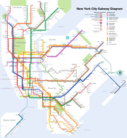
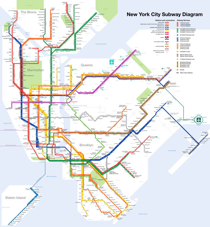
Čeština: Plán sítě newyorského metra Deutsch: Netzplan der New Yorker U-Bahn English: Map of the New York City Subway Español: Plano del Metro de Nueva York Français : Carte du métro de New York Română: Hartă a metroului din New York 中文: 纽约地铁路线图 |
| SVG genesis | |
| Tarix | |
| Mənbə | I created this work entirely by myself. Subway service information taken from the MTA. |
| Yaradıcı |
I, User:CountZ, Jake Berman. A link to my website, [1] would also be appreciated if you reuse this file. |
| Georeferencing | If inappropriate please set warp_status = skip to hide. |
| Digər versiyalar | File:NYC_subway-4C.svg, File:NYC_subway-4b-shrunk-2.svg |
Lisenziya
CountZ at ingilis Vikipediya, the copyright holder of this work, hereby publishes it under the following license:
Bu fayl Creative Commons Attribution-Share Alike 3.0 Unported lisenziyası altında yayımlanır.
Atribut:
- Siz heç bir məhdudiyyət olmadan:
- paylaşa bilərsiniz – əsəri köçürə, paylaya və ötürə bilərsiniz
- remiks edə bilərsiniz – əsəri adaptasiya edə bilərsiniz
- Aşağıdakı şərtlərə əməl etməklə:
- istinad vermək – Müvafiq istinad verməli, lisenziyaya keçid əlavə etməli və dəyişikliklər edilib-edilmədiyini bildirməlisiniz . Siz bunu istənilən şəkildə edə bilərsiniz, lakin lisenziya verənin sizə şəxsən icazə verdiyini göstərən formada yox.
- bənzər paylaşma – Əsəri remix edirsinizsə, dəyişdirirsinizsə və ya üzərində iş aparırsınızsa, öz töhfələrinizi orijinalda olduğu kimi eyni və ya uyğun lisenziya altında yayımlamalısınız.
Assessment
|
This image was selected as picture of the day on Wikimedia Commons for 8 October 2011. It was captioned as follows: English: Map of the New York City Subway Other languages:
Čeština: Plán sítě newyorského metra s anglickými popisky, stav říjen 2011 Dansk: Kort over New York City Subway. English: Map of the New York City Subway Español: Mapa del Metro de la Ciudad de Nueva York (EE.UU.) Français : Carte du métro de New York Italiano: Mappa della metropolitana di New York. Magyar: New York-i metró térképe. Nederlands: Kaart van de metro van New York Română: Hartă a metroului din New York. Русский: Схема Нью-йоркского метрополитена Українська: Карта Нью-Йоркського метрополітену. 한국어: 뉴욕 지하철 노선도. 日本語: ニューヨーク市の地下鉄路線図 中文: 纽约地铁线路图。 |
Orijinal yükləmə gündəliyi
Transferred from en.wikipedia to Commons by Train2104 using CommonsHelper.
The original description page was here. All following user names refer to en.wikipedia.
- 2011-02-16 23:04 CountZ 2500×2700 (3397859 bytes) minor modifications
- 2011-02-04 21:28 CountZ 2500×2700 (3381913 bytes) added neighborhoods and borough lines
- 2011-01-20 16:12 CountZ 2500×2700 (3072936 bytes) Modified Staten Island service to show ferry connections; clarified Times Sq wheelchair access
- 2011-01-15 22:33 Train2104 2500×2700 (5298094 bytes) Corrected naming of certain stations, line color to match {{NYCS color}}, Ballpark closed
- 2011-01-11 17:29 CountZ 2500×2700 (3075835 bytes) rearranged herald square, fixed PATH stations
- 2011-01-11 00:18 CountZ 2500×2700 (3053095 bytes) Past upload did not upload correctly.
- 2011-01-11 00:13 CountZ 2500×2700 (3052896 bytes) Corrected error on the Broadway Line
- 2011-01-10 21:23 CountZ 2500×2700 (3232134 bytes) comprehensive rework of the map
- 2010-12-31 17:11 CountZ 2500×2700 (3234151 bytes) Updated Nostrand Avenue service pattern
- 2010-12-11 17:11 CountZ 2500×2700 (3230578 bytes) Added Jay Street-Lawrence Street transfer Renamed Fulton-Broadway-Nassau to its new name (Fulton Street)
- 2010-09-23 15:03 CountZ 2500×2700 (3237347 bytes) minor updates, including B/Q on the Brighton Line
- 2010-05-31 15:26 CountZ 2500×2700 (3213246 bytes) minor edits for new service changes
- 2010-04-16 17:44 CountZ 2500×2700 (3199398 bytes) Updated to reflect MTA service changes
- 2010-03-02 21:34 CountZ 2500×2700 (3222199 bytes) minor update to test Illustrator
- 2010-01-18 22:20 CountZ 2500×2700 (3237236 bytes) Update: Added Staten Island express service.
- 2009-12-20 19:08 Dream out loud 2500×2700 (4410399 bytes) fixed blue (water) background
- 2009-12-19 03:10 Dream out loud 2500×2700 (4385399 bytes) updated 4 Oct 2009 edit - cleaned up AirTrain JFK, added endashes, updated Aqueduct Racetrack and Cortlandt St BMT
- 2009-11-25 06:58 Dream out loud 2500×2700 (4010699 bytes) converted text to path
- 2009-11-25 06:52 Dream out loud 2500×2700 (3950043 bytes) added endashes to subway services, fixed AirTrain JFK stations
- 2009-11-17 17:05 Dream out loud 2500×2700 (3481944 bytes) added northbound service only for Aqueduct Racetrack
- 2009-10-04 13:53 CountZ 2500×2700 (3218417 bytes) Minor edit: slightly untangled the Eastern Pkwy line.
- 2009-09-30 13:49 CountZ 2500×2700 (3216925 bytes) Minor edit: AirTrain JFK station names fixed.
- 2009-09-30 02:17 CountZ 2500×2700 (3200805 bytes) Okay, it should work this time. Was uploading the wrong file version.
- 2009-09-30 02:12 CountZ 2500×2700 (3196471 bytes) Funny, it didn't remove. Let's try again.
- 2009-09-30 02:06 CountZ 2500×2700 (3196471 bytes) Watermark removed
- 2009-09-27 15:25 CountZ 2500×2700 (3195870 bytes) Fixed a couple of street names: 9 -> 9 St; 125 -> 125 St; 8 St -> 8 St/ NYU
- 2009-09-27 15:16 CountZ 2500×2700 (3196585 bytes)
- 2009-09-27 14:48 CountZ 2500×2700 (3195913 bytes) Corrected j-z skip-stop service in Brooklyn.
- 2009-09-26 20:23 CountZ 2500×2700 (3197825 bytes) {{Information |Description = Map of the New York Subway |Source = I (~~~) created this work entirely by myself. Also: [http://www.mta.info/nyct/maps/submap.htm] |Date = ~~~~~ |Author = ~~~ |other_versions = [[:File:NYC_su
Faylın tarixçəsi
Faylın əvvəlki versiyasını görmək üçün gün/tarix bölməsindəki tarixlərə klikləyin.
| Tarix/Vaxt | Miniatür | Ölçülər | İstifadəçi | Şərh | |
|---|---|---|---|---|---|
| hal-hazırkı | 04:39, 8 dekabr 2022 | | 512 × 553 (2,63 MB) | TFSyndicate | Added more 'accessible station' symbols |
| 17:36, 16 noyabr 2021 |  | 512 × 553 (2,63 MB) | TFSyndicate | Additional minor revisions | |
| 17:32, 16 noyabr 2021 |  | 512 × 553 (2,65 MB) | TFSyndicate | Revised to include new station names, new part-time transfer at Times Square, and rush hour express and extension. | |
| 14:40, 24 fevral 2019 |  | 2.500 × 2.700 (3,66 MB) | Dream out loud | fixed code to pass W3 validation, removed random floating text, removed water background border, redrew Brooklyn/Queens border based on official map, reshaped Rockaway Peninsula, reshaped Staten Island | |
| 15:16, 19 sentyabr 2018 |  | 2.500 × 2.700 (3,72 MB) | PrecipiceofDuck | Updated with opening of WTC Cortlandt and N train stopping at 45 St and 53 St | |
| 11:45, 29 may 2018 |  | 2.500 × 2.700 (3,65 MB) | Dream out loud | fixed AirTrain JFK name and stations | |
| 01:47, 2 fevral 2018 |  | 2.500 × 2.700 (3,73 MB) | PrecipiceofDuck | Updated to correct 2 spelling errors, and to reflect ADA accessibility at Ozone Park-Lefferts Blvd and ADA accessibility/connection between World Trade Center E and Cortlandt St R/W | |
| 04:54, 21 yanvar 2017 |  | 2.500 × 2.700 (3,72 MB) | PrecipiceofDuck | Updated with opening of Arthur Kill station on the SIR and ADA accessibility at 23 St on the Lexington Av line, also delisting the limited rush hour services | |
| 00:36, 2 yanvar 2017 |  | 2.500 × 2.700 (3,75 MB) | PrecipiceofDuck | Updated with 2nd Ave line and other small changes | |
| 13:49, 16 yanvar 2016 |  | 2.500 × 2.700 (2,83 MB) | CountZ | Updated to reflect 24-hour J service in Lower Manhattan |
Faylın istifadəsi
Aşağıdakı səhifə bu faylı istifadə edir:
Faylın qlobal istifadəsi
Bu fayl aşağıdakı vikilərdə istifadə olunur:
- ar.wikipedia.org layihəsində istifadəsi
- ba.wikipedia.org layihəsində istifadəsi
- be-tarask.wikipedia.org layihəsində istifadəsi
- be.wikipedia.org layihəsində istifadəsi
- bg.wikipedia.org layihəsində istifadəsi
- bn.wikipedia.org layihəsində istifadəsi
- ca.wikipedia.org layihəsində istifadəsi
- crh.wikipedia.org layihəsində istifadəsi
- cv.wikipedia.org layihəsində istifadəsi
- de.wikipedia.org layihəsində istifadəsi
- el.wikipedia.org layihəsində istifadəsi
- el.wikivoyage.org layihəsində istifadəsi
- en.wikipedia.org layihəsində istifadəsi
- New York City Subway
- Proposed expansion of the New York City Subway
- Wikipedia:WikiProject Trains
- New York City Subway stations
- Topological map
- User talk:CountZ
- Transit map
- Portal:Technology/Selected pictures
- Wikipedia:Featured pictures/Diagrams, drawings, and maps/Maps
- Portal:New York City/Selected picture/Archives
- Wikipedia:Graphics Lab/Resources/Draw topological maps
- Wikipedia:Featured pictures thumbs/20
- List of New York City Subway stations in the Bronx
- Wikipedia:Featured picture candidates/New York subway diagram
- Wikipedia:Featured picture candidates/October-2009
- Wikipedia:Wikipedia Signpost/2009-10-05/Features and admins
- List of New York City Subway stations in Manhattan
- List of New York City Subway stations in Brooklyn
- List of New York City Subway stations in Queens
- Wikipedia:WikiProject United States/Recognized content
- Wikipedia talk:WikiProject New York City Public Transportation/Archive 14
- Wikipedia:WikiProject United States/Quality content
- Wikipedia:Picture of the day/March 2011
- Template:POTD/2011-03-18
- Wikipedia:Main Page history/2011 March 18
- Wikipedia talk:WikiProject New York City Public Transportation/Archive 16
- Talk:New York City Subway/Archive 3
- Portal:New York City/Selected picture/19
- Wikipedia talk:WikiProject New York City Public Transportation/Archive 17
- Wikipedia:Wikipedia Signpost/2009-10-05/SPV
- Talk:New York City Subway stations/sandbox
- User:Another Believer/Travel/United States
- List of New York City Subway stations
- Wikipedia:WikiProject Trains/Featured content
- Wikipedia:WikiProject United States/Featured pictures
- User:Dargananddrago/Transportation planner(Fake)
Bu faylın qlobal istifadəsinə baxın.