Category:Rongbuk Glacier
glacier in the People's Republic of China  | |||||
| Upload media | |||||
| Instance of | |||||
|---|---|---|---|---|---|
| Location |
| ||||
| Mountain range | |||||
 | |||||
Media in category "Rongbuk Glacier"
The following 47 files are in this category, out of 47 total.
-
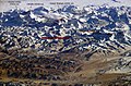
 1966-03 1966年珠穆朗玛峰.jpg 791 × 542; 609 KB
-
 5,200m Chomoranma Base Camp Tibet China 西藏 珠穆朗玛峰 - panoramio (3).jpg 2,400 × 1,800; 2.96 MB
-
 Detail, Everest and Changtse, 1921 (cropped).jpg 706 × 437; 48 KB
-
 Everest and Changtse, 1921.jpg 892 × 559; 58 KB
-
 Everest from Rongbuk valley, 1921.jpg 500 × 295; 115 KB
-
 Everest North Face toward Base Camp Tibet Luca Galuzzi 2006 (3to4).jpg 1,777 × 1,333; 987 KB
-
 Everest North Face toward Base Camp Tibet Luca Galuzzi 2006 (square).jpg 1,333 × 1,333; 776 KB
-
 Everest North Face toward Base Camp Tibet Luca Galuzzi 2006 edit 1.jpg 2,000 × 1,333; 838 KB
-
 Everest North Face toward Base Camp Tibet Luca Galuzzi 2006.jpg 2,000 × 1,333; 883 KB
-
 Everest reconnaissance expedition, 1921.svg 1,000 × 658; 1.72 MB
-
 Everest, northern approaches.svg 679 × 555; 174 KB
-
 Everest-3D-Map-Type-EN.jpg 5,000 × 3,750; 4.28 MB
-
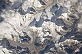
 Everestfromspace.jpg 1,326 × 1,033; 209 KB
-
 Geology of Everest region, 1921.jpg 6,084 × 3,888; 5.51 MB
-
 Himalaya annotated.jpg 1,000 × 662; 413 KB
-
 Himalayas.jpg 3,032 × 1,998; 3.78 MB
-
 ISS022-E-7203 - View of Nepal.jpg 4,288 × 2,848; 1.62 MB
-

-
 ISS022-E-7204 - View of China.jpg 4,288 × 2,848; 1.45 MB
-
 ISS022-E-7205 - View of China.jpg 4,288 × 2,848; 1.43 MB
-
 ISS022-E-7206 - View of China.jpg 4,288 × 2,848; 1.36 MB
-
 ISS066-E-86203 - View of Earth.jpg 5,568 × 3,712; 2.93 MB
-

-

-

-

-

-

-

-

-
 ISS066-E-86253 - View of China.jpg 5,568 × 3,712; 5.41 MB
-
 Karte Mount Everest.png 1,000 × 1,000; 1.1 MB
-
 Kharta from 1921 map.jpg 1,257 × 961; 196 KB
-

-
 Mallory's original map of northeast of Everest.jpg 341 × 500; 20 KB
-
 Mount Everest Climbing Routes 1924-1996 photomap-fr.svg 1,208 × 900; 1.11 MB
-
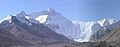
 Mount Everest from Rongbuk may 2005.JPG 3,008 × 2,000; 1.12 MB
-
 Mount Everest from the Rongbuk Glacier in the 1920s.jpg 560 × 732; 104 KB
-
 Mount everest.jpg 1,024 × 681; 337 KB
-
 MountEverest-from-tibet-base-camp.jpg 3,688 × 1,440; 880 KB
-
 Nature (1922) (14577542248).jpg 1,852 × 1,350; 470 KB
-
 North Col of Mount Everest.jpg 720 × 480; 165 KB
-
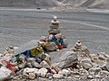 Praying flags at Tibet Expedition start place to Everest , Tibet - panoramio.jpg 2,608 × 1,952; 1.91 MB
-
 Preliminary map of Mount Everest Expedition, 1921. Map I.jpg 6,284 × 3,900; 2.22 MB
-
 Preliminary Map of Mount Everest. Howard-Bury, 1922.jpg 5,464 × 4,388; 2.6 MB
-
 Rongbuk Glacier animation.gif 990 × 610; 1.68 MB
-
 Routes near Mount Everest, 1950 and 1951.svg 1,080 × 810; 177 KB

.jpg)
.jpg)


.jpg)
.jpg)


_-_West_Rongbuk_and_Pumori_Glacier_-_NomouLi_-_Mount_Lingtren_-_clouds_(cropped).jpg)


.jpg)
.jpg)
.jpg)
.jpg)
.jpg)
_-_Rongbuk_Co_(lake)_-_West_Rongbuk_Glacier_-_Pumori_-_Khangri_Shar_-_Chumbu_-_West_Lingtren_-_Tongqiang_Ri_-_Hongxing_Ri_(cropped).jpg)
_-_Rongbuk_Co_(lake)_-_Kellas_Rock_Peak_-_Dongfang_mountain_chain_-_Changzheng_Ri_-_Shuguang_-_Hongxing_Ri_-_Rongbuk_Glacier_(cropped).jpg)
_Glacier_-_Tongqiang_Ri_-_Hongxing_Ri_-_Hongxing_Glacier_-_Shuguang_(cropped).jpg)


.jpg)


_(14577542248).jpg)


