Category:Rishiri Island
English: Rishiri Island in Hokkaido, Japan.
日本語: 日本国北海道にある利尻島に関するカテゴリ。
island in Hokkaido, Japan      | |||||
| Upload media | |||||
| Instance of | |||||
|---|---|---|---|---|---|
| Part of | |||||
| Located in protected area | |||||
| Location | Sea of Japan | ||||
| Located in or next to body of water | |||||
| Width |
| ||||
| Length |
| ||||
| Highest point | |||||
| Population |
| ||||
| Area |
| ||||
| Elevation above sea level |
| ||||
| official website | |||||
 | |||||
Subcategories
This category has the following 2 subcategories, out of 2 total.
M
O
- Otatomari Pond (3 F)
Media in category "Rishiri Island"
The following 33 files are in this category, out of 33 total.
-
 Brown butterfly1-02.jpg 4,288 × 3,216; 1.35 MB
-
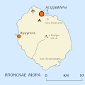
 JP Hokkaido Rishiri Island Location.PNG 1,257 × 760; 59 KB
-
 Kitanoitsukushima.jpg 3,840 × 2,160; 5.7 MB
-
 Lava rocks, Senhoshi Misaki Park, Rishiri Island, Japan.jpg 5,655 × 3,812; 10.29 MB
-
 Minois dryas on Rishiri Island1.jpg 3,165 × 2,374; 1.1 MB
-
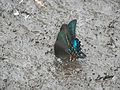 Papilio maackii on Rishiri Island1.jpg 4,288 × 3,216; 1.47 MB
-
 Papilio maackii on Rishiri Island2.jpg 2,041 × 1,533; 427 KB
-
 Papilio maackii on Rishiri Island3.jpg 4,288 × 3,216; 1.6 MB
-
 Papilio maackii on Rishiri Island4.jpg 4,288 × 3,216; 2.44 MB
-
 Papilio maackii on Rishiri Island5.jpg 4,288 × 3,216; 2.51 MB
-
 Rishiri Airport 17-Sept-2018 p2.jpg 6,016 × 4,016; 3.78 MB
-
 Rishiri be.gif 600 × 600; 14 KB
-
 Rishiri Island 20140814-2.jpg 3,872 × 2,592; 2.77 MB
-
 Rishiri Island 20140814-3.jpg 3,872 × 2,592; 2.88 MB
-
 Rishiri Island 20140814-4.jpg 3,872 × 2,592; 3.08 MB
-
 Rishiri Island 20140814.jpg 3,872 × 2,592; 3.1 MB
-
 Rishiri Island 20140815-2.jpg 3,872 × 2,592; 3.01 MB
-
 Rishiri Island 20140815-3.jpg 3,872 × 2,592; 2.89 MB
-
 Rishiri Island 20140815.jpg 3,872 × 2,592; 2.85 MB
-
 Rishiri Island from Rebun.JPG 3,072 × 2,304; 1.13 MB
-
 Rishiri island in Soya Subprefecture.gif 600 × 331; 31 KB
-
 Rishiri Island.jpg 3,456 × 2,304; 2.03 MB
-
 Rishiri island1.JPG 4,416 × 3,312; 6.83 MB
-
 Rishiri island10.jpg 4,416 × 3,312; 6.83 MB
-
 Rishiri Relief Map, SRTM.jpg 1,200 × 1,200; 441 KB
-
 Rishiriislandairplane.jpg 3,412 × 2,275; 2.62 MB
-

-
 Von Karman vortices off Rishiri Island, Japan.jpg 3,000 × 3,000; 2.1 MB
-
 利尻島 - panoramio (1).jpg 1,600 × 1,200; 290 KB
-
 利尻島 - panoramio.jpg 1,600 × 1,137; 289 KB
-
 礼文岳山頂から見る利尻山.jpg 1,600 × 1,200; 323 KB
-
 納沙布岬 - panoramio (1).jpg 3,994 × 2,595; 4.47 MB
-
 道道108号線 - panoramio (2).jpg 1,600 × 1,200; 243 KB


.jpg)


.jpg)
.jpg)