Category:Mount Mitchell
Mount Mitchell, which at 6,684 feet (2,037 m) is the highest summit in the Appalachian Mountains, in the eastern United States.
Highest mountain in the Eastern United States  | |||||
| Upload media | |||||
| Instance of | |||||
|---|---|---|---|---|---|
| Named after | |||||
| Located in protected area | |||||
| Location | Yancey County, North Carolina | ||||
| Owned by |
| ||||
| Mountain range | |||||
| Topographic prominence |
| ||||
| Topographic isolation |
| ||||
| Has climbing route | |||||
| Elevation above sea level |
| ||||
 | |||||
Subcategories
This category has the following 5 subcategories, out of 5 total.
E
- Elisha Mitchell's tomb (7 F)
M
- Views from Mount Mitchell (40 F)
- Mount Mitchell Summit Trail (18 F)
Media in category "Mount Mitchell"
The following 109 files are in this category, out of 109 total.
-

-
-

-

-

-
-

-

-

-

-

-

-

-

-

-

-
 Abies fraseri foliage.jpg 2,048 × 1,536; 2.09 MB
-
 Abies fraseri Mitchell.jpg 2,048 × 1,536; 1.43 MB
-
 Balsam Nature Trail - panoramio (1).jpg 3,264 × 2,345; 2.66 MB
-
 Balsam Nature Trail - panoramio.jpg 3,264 × 2,448; 2.48 MB
-
 Bluets near the Mount Mitchell summit (7651433308).jpg 4,416 × 3,312; 5.24 MB
-
 Bumblebee at Mount Mitchell (37080288550).jpg 4,180 × 2,787; 5.16 MB
-
 Butterfly at Mount Mitchell (37289425126).jpg 4,681 × 3,121; 7.71 MB
-
 Clearing on the Mount Mitchell Trail 1.6 miles from the top - panoramio.jpg 3,264 × 2,448; 2.18 MB
-

-
 Gymnopilus bellulus (Peck) Murrill 368592.jpg 4,572 × 2,634; 8.47 MB
-
 Gymnopilus bellulus (Peck) Murrill 368594.jpg 3,888 × 2,007; 5.43 MB
-
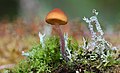 Gymnopilus bellulus 368591.jpg 4,012 × 2,428; 5.03 MB
-
 Horrifying Falls wiki.jpg 2,400 × 2,939; 1.62 MB
-
 Janet Mizzi takes in the view from Mount Mitchell (37289406516).jpg 6,000 × 4,000; 7.71 MB
-
 Mitchell View - North Carolina, USA (25474678730).jpg 4,000 × 3,000; 2.02 MB
-
 Mitchell-clingmans-peak-nc1.jpg 1,199 × 899; 270 KB
-
 Mount Mitchell (North Carolina) - panoramio.jpg 3,264 × 2,448; 3.2 MB
-
 Mount Mitchell 5.6 miles - panoramio.jpg 2,345 × 2,448; 2.34 MB
-
 Mount Mitchell 640x480.jpg 640 × 480; 292 KB
-
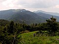
 Mount Mitchell and Mount Craig from Black Mountains Overlook, October 2016.jpg 5,184 × 3,456; 6.73 MB
-
 Mount Mitchell Fall Foliage.JPG 2,272 × 1,704; 2.42 MB
-
 Mount Mitchell Forest Floor.jpg 3,008 × 2,000; 3.69 MB
-
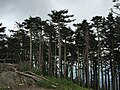
 Mount Mitchell Forest.jpg 3,024 × 1,998; 4.18 MB
-
 Mount Mitchell from Blue Ridge Parkway.jpg 3,020 × 1,286; 3 MB
-
 Mount Mitchell from Mt. Mitchell overlook NC.jpg 3,843 × 2,562; 1.14 MB
-
-
 Mount Mitchell in the summer.jpg 4,032 × 3,024; 5.23 MB
-
 Mount Mitchell marker.jpg 2,592 × 1,936; 2.26 MB
-
 Mount Mitchell mid-hike trail reward - panoramio.jpg 3,264 × 2,448; 1.14 MB
-
 Mount Mitchell path to observation tower - panoramio (1).jpg 3,264 × 2,448; 1.62 MB
-
 Mount Mitchell path to observation tower - panoramio.jpg 3,264 × 2,139; 1.22 MB
-
 Mount Mitchell sign, North Carolina.jpg 3,152 × 1,936; 1.19 MB
-
 Mount Mitchell sign.jpg 2,592 × 1,936; 2.17 MB
-
 Mount Mitchell State Park - panoramio (1).jpg 1,881 × 2,016; 536 KB
-
 Mount Mitchell State Park - panoramio.jpg 2,448 × 3,264; 1.98 MB
-
 Mount Mitchell Summit Trail ^ Balsam Nature Trail - panoramio.jpg 3,264 × 2,448; 3.21 MB
-
 Mount Mitchell Summit View - panoramio (1).jpg 3,264 × 2,353; 1.72 MB
-
 Mount Mitchell summit view - panoramio (1).jpg 3,264 × 2,448; 781 KB
-
 Mount Mitchell Summit View - panoramio.jpg 3,264 × 2,448; 939 KB
-
 Mount Mitchell top Forest - panoramio.jpg 3,264 × 2,448; 3.26 MB
-
 Mount Mitchell Trail - panoramio (1).jpg 2,448 × 3,264; 1.87 MB
-
 Mount Mitchell Trail - panoramio (2).jpg 2,448 × 3,264; 3.14 MB
-
 Mount Mitchell Trail - panoramio (3).jpg 3,264 × 2,448; 3.21 MB
-
 Mount Mitchell Trail - panoramio (4).jpg 3,264 × 2,448; 3.86 MB
-
 Mount Mitchell Trail - panoramio (5).jpg 2,448 × 3,264; 3.46 MB
-
 Mount Mitchell Trail - panoramio.jpg 3,264 × 2,448; 3.33 MB
-
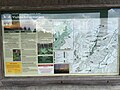
 Mount Mitchell Trail Info - panoramio.jpg 3,264 × 2,448; 3.97 MB
-
 Mount Mitchell Trail sign - panoramio.jpg 2,448 × 3,264; 1.02 MB
-
 Mount Mitchell viewed from Mount Mitchell State Park Restaurant, Oct 2016.jpg 3,692 × 2,425; 4.93 MB
-
 Mount Mitchell-27527.jpg 2,000 × 1,100; 1.16 MB
-
 Mount Mitchell.jpg 448 × 292; 42 KB
-
 Mount-mitchell-logged-trees-nc1.jpg 497 × 346; 37 KB
-
 Mount-mitchell-south-nc1.jpg 1,118 × 609; 164 KB
-
 Mountain St. John's Wort Wildflower, Mt Mitchell SP NC 9016.jpg 1,622 × 1,499; 1.11 MB
-
 Mountains-to-Sea Trail - panoramio.jpg 2,259 × 2,875; 2.91 MB
-
 Mountains-to-Sea Trail sign - panoramio.jpg 3,264 × 2,448; 2.37 MB
-
 MountMitchell.jpg 3,072 × 2,048; 1.89 MB
-
 Mt Mitchell (13158389054).jpg 1,600 × 2,400; 1.29 MB
-
 Mt Mitchell Ferns (13158235623).jpg 2,400 × 1,600; 1.87 MB
-
 Mt Mitchell Forest (13158392484).jpg 2,400 × 1,600; 1.23 MB
-
 Mt Mitchell from from Black Mountains Overlook, October 2016.jpg 5,184 × 3,456; 6.81 MB
-
 Mt. Mitchel plaque at summit.jpg 3,024 × 4,032; 2.92 MB
-
 Mt. Mitchell Reservation, N.C. Bynums Bluff LCCN90715626.jpg 4,096 × 3,264; 2.44 MB
-
 Mt. Mitchell Reservation, N.C. Bynums Bluff LCCN90715627.jpg 4,096 × 3,276; 2.5 MB
-
 Mt. Mitchell Reservation, North Carolina, with waterfalls in foreground LCCN90715628.jpg 3,254 × 4,096; 1.97 MB
-
 Parking lot atop Mount Mitchell.jpg 4,288 × 2,848; 8.25 MB
-
 Pausing for a little birding near the summit of Mount Mitchell (7651422108).jpg 4,416 × 3,312; 7.45 MB
-
 Pisgah National Forest - panoramio (1).jpg 3,264 × 2,448; 1.24 MB
-
 Pleurocybella porrigens (Pers.) Singer 463464.jpg 2,395 × 1,795; 2.02 MB
-

-
 Sign on Mount Mitchell.jpg 3,857 × 2,328; 5.83 MB
-
 South Toe River - panoramio (1).jpg 1,973 × 2,243; 1.2 MB
-
 South Toe River - panoramio.jpg 3,264 × 2,448; 2.62 MB
-
 South Toe, NC, USA - panoramio (1).jpg 3,264 × 2,448; 3.23 MB
-
 South Toe, NC, USA - panoramio (2).jpg 2,448 × 3,264; 3.19 MB
-
 South Toe, NC, USA - panoramio (4).jpg 3,264 × 2,448; 746 KB
-
 South Toe, NC, USA - panoramio (5).jpg 3,264 × 2,448; 1.26 MB
-
 South Toe, NC, USA - panoramio (7).jpg 3,264 × 2,448; 701 KB
-
 Spruce-Fir Forest on Mount Mitchell.jpg 3,008 × 2,000; 4.36 MB
-
 Sunset colors on the trail descent - panoramio.jpg 2,760 × 1,643; 378 KB
-
 Tree on Mount Mitchell, Oct 2016 1.jpg 3,456 × 5,184; 8.21 MB
-
 Tree on Mount Mitchell, Oct 2016 2.jpg 5,184 × 3,456; 8.78 MB
-
 Unofficial Mount Mitchell benchmark - panoramio.jpg 2,048 × 1,536; 1.51 MB
-
 View from Mount Mitchell (36667175253).jpg 6,000 × 4,000; 7.32 MB
-
 View from Mt Michell.jpg 3,872 × 2,592; 2.26 MB
-

-

-
 Views from the top of Mt. Mitchell - 51400147876.jpg 4,032 × 3,024; 3.48 MB
-
 Views from the top of Mt. Mitchell - 51400406433.jpg 4,032 × 2,392; 1.31 MB
-
 Views from the top of Mt. Mitchell - 51400917554.jpg 4,032 × 3,024; 3.79 MB
-
 Views from the top of Mt. Mitchell.jpg 4,032 × 3,024; 3.28 MB
-
 Walking down from the summit.jpg 2,790 × 3,721; 3.97 MB
-
 Weather Information - panoramio.jpg 3,264 × 2,448; 1.8 MB
_Brian_Cole,_Sue_Cameron,_Chris_Kelly,_Leo_Miranda,_Mara_Alexander_at_Mount_Mitchell_(7651432148).jpg)


.jpg)


.jpg)

.jpg)
.jpg)
.jpg)

_(14801840473).jpg)
_Murrill_368592.jpg)
_Murrill_368594.jpg)


.jpg)
.jpg)

_-_panoramio.jpg)


.jpg)


.jpg)


.jpg)
.jpg)


.jpg)
.jpg)
.jpg)
.jpg)
.jpg)


.jpg)
.jpg)
.jpg)


.jpg)
.jpg)
_Singer_463464.jpg)
.jpg)

.jpg)

.jpg)
.jpg)
.jpg)
.jpg)
.jpg)


.jpg)


