Butun axtardiqlarinizi tapmaq ucun buraya: DAXIL OLUN
  Mp4 Mp3 Axtar Yukle
  Video Axtar Yukle
  Shekil Axtar Yukle
  Informasiya Melumat Axtar
  Hazir Inshalar Toplusu
  AZERI CHAT + Tanishliq
  Saglamliq Tibbi Melumat
  Whatsapp Plus Yukle(Yeni)

  • Home
  • Random
  • Nearby
  • Log in
  • Settings
Donate Now If this site has been useful to you, please give today.
  • About Wikimedia Commons
  • Disclaimers

Category:Komsomolets Island

<nowiki>Isla Komsomolets; Komszomolec-sziget; Islla Komsomolets; illa Komsomólets; Ynys Komsomolets; Oileán Komsomolets; جزیره کومسومولتس; 共青团员岛; Komsomolets Adası; コムソモレツ島; Komsomoletsön; Комсомолець; Комсомолец (утрау); 共青團員島; 콤소몰레츠섬; Komsomolec; isola Komsomolec; île Komsomolets; Komsomoletsi saar; Illa Komsomolets; Đảo Komsomolets; 共青团员岛; Komsomoļeca; Komsomoletseiland; Komjaunuolio sala; Komsomolets; كومسوموليتس ايسلاند; Komsomoles; Ilha Komsomolets; เกาะคอมโซโมเลตส์; Komsomoletsøya; Komsomolez-Insel; Komsomolets; Комсомолец; Комсомолец; Komsomolec; Ostrov Komsomolets; Komsomolets Island; جزيرة كومسوموليتس; Νήσος Κομσομόλετς; Камсамолец; isla en Severnaya Zemlya, Rusia; রাশিয়ার একটি দ্বীপ; île de Russie; Sziget Oroszországban; rysk ö i Norra ishavet; ruský ostrov; острів Росії; eiland van Rusland; isola russa nell'Oceano Artico; island in Severnaya Zemlya, Russia; Insel in Russland; Venäjälle kuuluva saari Severnaja Zemljan saaristossa Pohjoisella jäämerellä; ishull; セヴェルナヤ・ゼムリャ諸島の島; 北冰洋一座岛屿; Isla; Остров Комсомолец; ostrov Komsomolec</nowiki>
Komsomolets Island 
island in Severnaya Zemlya, Russia
Krenkelova zátoka
Upload media
 Wikipedia
Instance of
  • island
Part of
  • Severnaya Zemlya
Named after
  • All-Union Leninist Young Communist League
LocationKara Sea, Arctic Ocean, international waters
Located in or next to body of water
  • Kara Sea
  • Laptev Sea
Time of discovery or invention
  • 1913
Width
  • 75 km
Length
  • 120 km
Population
  • 0
Area
  • 9,006 km²
Elevation above sea level
  • 935 m
Map80° 29′ 03″ N, 94° 59′ 47″ E
Authority file
Wikidata Q248654
BabelNet ID:
OpenStreetMap relation ID:
  • Reasonator
  • Scholia
  • Wikidocumentaries
  • PetScan
  • statistics
  • WikiMap
  • Locator tool
  • KML file
  • WikiShootMe
  • OpenStreetMap
  • Search depicted
Edit infobox data on Wikidata

Subcategories

This category has the following 4 subcategories, out of 4 total.

A

  • Academy of Sciences Glacier (3 F)

K

  • Krenkel Bay (2 F)

M

  • Maps of Komsomolets Island (6 F)

Z

  • Zhuravlev Bay (4 F)

Media in category "Komsomolets Island"

The following 6 files are in this category, out of 6 total.

  • Kap Arktitscheski 1 2014-08-31.jpg 4,251 × 2,834; 877 KB
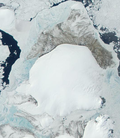
  • KomsomoletsIsland Terra MODIS.png 530 × 610; 354 KB
  • Polarstation Izluchina 2014-08-31.jpg 2,125 × 1,416; 146 KB
  • RussiaKomsomoletsIsland.png 300 × 178; 33 KB
  • Severnaya Zemlya Banner.jpg 2,125 × 304; 55 KB
  • Île de la Révolution d'Octobre vue par le satellite Sentinel 2.jpg 5,000 × 5,000; 23.04 MB
Retrieved from "/w/index.php?title=Category:Komsomolets_Island&oldid=303957026"
Informasiya Melumat Axtar