Category:Kochubeyevsky District
municipal district in Russia  .png)  .svg) | |||||
| Upload media | |||||
| Instance of |
| ||||
|---|---|---|---|---|---|
| Location |
| ||||
| Capital |
| ||||
| Inception |
| ||||
| Population |
| ||||
| Area |
| ||||
| official website | |||||
 | |||||
Subcategories
This category has the following 3 subcategories, out of 3 total.
B
I
Media in category "Kochubeyevsky District"
The following 13 files are in this category, out of 13 total.
-
 Coat of Arms of Kochubeyevsky rayon.png 574 × 700; 201 KB
-
 Flag of Kochubeevsky rayon (Stavropol krai).png 722 × 483; 172 KB
-
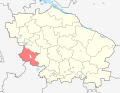 Location of Kochubeyevsky District (Stavropol Krai).svg 512 × 397; 190 KB
-
 Вид на село с горы - panoramio.jpg 1,600 × 1,200; 440 KB
-
 Герб Сельского поселения Село Кочубеевское.gif 238 × 310; 24 KB
-
 Лен-Flax - panoramio.jpg 3,264 × 2,448; 3.29 MB
-
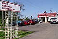 Магазин "Колбаска" - panoramio.jpg 2,754 × 1,881; 3.38 MB
-
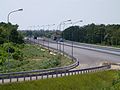 Новая дорожная развязка - panoramio.jpg 3,264 × 2,448; 3.7 MB
-
 Свидетельство о регистрации в ГГР № 9990.jpg 565 × 393; 133 KB
-
 Свидетельство о регистрации в ГГР № 9991.jpg 570 × 400; 141 KB
-
 Флаг Сельского поселения Село Кочубеевское.gif 200 × 124; 558 bytes
-
 Церковь Василия Блаженного (Тоннельный).jpg 4,151 × 2,843; 7.24 MB
-
 Церковь св.Николая Чудотворца.jpg 3,120 × 4,208; 1.08 MB


.jpg)
