Category:Kharimkotan
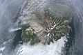
island in Kuril Islands, Russia  Zimní snímek ze stanice ISS (2002)  | |||||
| Upload media | |||||
| Instance of | |||||
|---|---|---|---|---|---|
| Part of |
| ||||
| Location | Severo-Kurilsky District, Sakhalin Oblast, Russia | ||||
| Located in or next to body of water |
| ||||
| Population |
| ||||
| Area |
| ||||
| Elevation above sea level |
| ||||
 | |||||
Kharimkotan (Харимкотан) / Harimukotan-tō (春牟古丹島)
Media in category "Kharimkotan"
The following 9 files are in this category, out of 9 total.
-
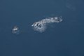
 ISS055-E-114533 - View of Earth.jpg 5,568 × 3,712; 1.19 MB
-
 ISS055-E-114534 - View of Earth.jpg 5,568 × 3,712; 1.21 MB
-
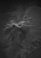
 Kharimkotan - ISS005.jpg 3,032 × 2,008; 1.17 MB
-
 Kharimkotan, Russia (2023-11-15-10-18-31 UMBRA-05).tiff 21,986 × 31,244, 7 pages; 897.31 MB
-
 Kharimkotan, Russia (2023-11-28-23-11-11 UMBRA-06).tiff 26,562 × 31,638, 7 pages; 1.05 GB
-
 Kuriles Kharimkotan.PNG 365 × 235; 4 KB
-
 Onekotan.jpg 640 × 631; 65 KB
-
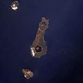 OnekotanNASA.jpg 3,800 × 3,800; 1.49 MB
-
 USSR map NM 56-9 Onnekotan-jima.jpg 5,000 × 3,906; 2.3 MB


