Category:Khairpur District
district of Sindh, Pakistan  | |||||
| Upload media | |||||
| Instance of | |||||
|---|---|---|---|---|---|
| Location | Sukkur Division, Sindh, Pakistan | ||||
| Capital | |||||
| Area |
| ||||
| Elevation above sea level |
| ||||
| official website | |||||
 | |||||
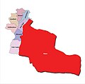
English: Khairpur District is a district in the Sindh province of Pakistan. The district has an area of 15,910 square kilometres and is headquartered at the city of Khairpur.
سنڌي: ضلع خيرپورپاڪستان جي صوبي سنڌ جو هڪ ضلعو آهي۔ 15 هزار 910 چورس ڪلوميٽر تي پکڙيل هي ضلعو سنڌ صوبي جي وڏن ضلعن منجهان هڪ آهي۔ ضلعي صدر مقام خيرپور ميرس جو شهر آهي۔
اردو: ضلع خیرپورپاکستان کے صوبہ سندھ کا ایک ضلع ہے۔ 15 ہزار 910 مربع کلومیٹر پر پھیلا ہوا یہ ضلع صوبے کے بڑے اضلاع میں سے ایک ہے۔ ضلعی صدر مقام خیرپور میرس کا شہر ہے۔
Khairpur District (Urdu:ضلع خیرپور) is a unit part of Pakistan. It is divided into 8 tehsils:
Subcategories
This category has the following 12 subcategories, out of 12 total.
B
- Bakri waro Lake (1 F)
K
- Kingri tehsil (7 F)
- Kot Diji Fort (156 F)
M
P
S
- Sheesh Mahal, Khairpur (3 F)
- Shrine of Sachal Sarmast (28 F)
Media in category "Khairpur District"
The following 59 files are in this category, out of 59 total.
-
 District Khairpur, Sindh, Pakistan.png 800 × 981; 195 KB
-
 Pakistan - Sindh - Khairpur district.svg 512 × 426; 579 KB
-
 Pakistan - Sindh - Khairpur.svg 915 × 1,098; 615 KB
-
 Sindh Dist KhairPur.svg 3,399 × 4,166; 547 KB
-
 Administration Naro Taluka Sindh.jpg 10,312 × 9,331; 4.07 MB
-
 Beauty of the village Mothparja after the rain 03.jpg 2,592 × 1,944; 930 KB
-
 Bereg wala bridge - panoramio.jpg 1,600 × 1,200; 342 KB
-
 Daud goth eid ghah - panoramio.jpg 1,600 × 1,200; 450 KB
-
 Deedar place at Rozay Dhani Dargah, Pir Jo Goth.jpg 4,032 × 3,024; 2.77 MB
-
 Gate Pir Syed Shah Mardan Shah Pir Pagaro.jpg 4,032 × 3,024; 1.88 MB
-
 Graveyard - panoramio - kamran.solangi.jpg 1,600 × 1,200; 254 KB
-
 Interior view of Rozay Dhani Dargah's Gate.jpg 3,024 × 4,032; 2.15 MB
-
 Interior view of Rozay Dhani Masjid at Pir jo Goth.jpg 3,024 × 4,032; 2.2 MB
-
 Jamani pull - panoramio.jpg 1,600 × 1,200; 495 KB
-
 Jamia Muhammadi Mosque , Mothparja.jpg 1,600 × 1,200; 152 KB
-
 Jamia Muhammadi Mosque Sahita Mohala, Mothparja.jpg 1,600 × 1,200; 95 KB
-
 Khairpur scene - panoramio.jpg 250 × 289; 11 KB
-
 Khairpur, Pakistan - panoramio (3).jpg 4,384 × 3,288; 4.56 MB
-
 Khedo goth mosque - panoramio.jpg 1,600 × 1,200; 498 KB
-
 Kot Banglow Highway - panoramio.jpg 1,600 × 1,200; 319 KB
-
 Kumb Main Road - panoramio.jpg 1,600 × 1,200; 295 KB
-
 Madani Mosque, Mothparja Exterior.jpg 1,600 × 1,200; 225 KB
-
 Madani Mosque, Mothparja.jpg 1,200 × 1,600; 149 KB
-
 Main Bazar Choondiko - panoramio.jpg 1,600 × 1,200; 281 KB
-
 Main Chowk Choondiko - panoramio.jpg 1,600 × 1,200; 244 KB
-
 Main Road Kumb - panoramio - kamran.solangi (1).jpg 1,600 × 1,200; 315 KB
-
 Main Road Kumb - panoramio.jpg 1,600 × 1,200; 315 KB
-
 Masjid and Dargah Rozay Dhani, Pir Jo Goth, Sindh.jpg 3,024 × 4,032; 2.58 MB
-
 Mehranu.jpg 3,264 × 2,448; 3.88 MB
-
 Mother Child Helath at Gambat Institute of Medical Sciences.jpg 300 × 224; 56 KB
-
 Naro Taluka Sindh.jpg 1,080 × 1,074; 99 KB
-
 National Highway - panoramio - kamran.solangi (2).jpg 1,600 × 1,200; 263 KB
-
 Near Panhyar Village - panoramio.jpg 1,600 × 1,200; 391 KB
-
 New ADOE and OMV Office - panoramio.jpg 1,600 × 1,200; 273 KB
-
 New ADOE and OMV Office Choondiko - panoramio.jpg 1,600 × 1,200; 232 KB
-
 Nice View - panoramio - kamran.solangi.jpg 1,600 × 1,200; 246 KB
-
 Nice View in Panhyar Village - panoramio.jpg 1,200 × 1,600; 180 KB
-
 Nice View Near Hingorja - panoramio.jpg 1,493 × 871; 137 KB
-
 Nice View of Panhyar Village - panoramio.jpg 1,600 × 1,200; 300 KB
-
 Outer view of Rozay Dhani Masjid, Pir jo Goth, Khairpur Mir's.jpg 3,024 × 4,032; 2.88 MB
-
 Panhyar Village - panoramio - kamran.solangi (1).jpg 1,200 × 1,600; 280 KB
-
 Panhyar Village - panoramio - kamran.solangi.jpg 1,600 × 1,200; 366 KB
-
 Panhyar Village - panoramio.jpg 1,600 × 1,200; 411 KB
-
 Rasool Abad jatoi muhalla - panoramio.jpg 2,592 × 1,944; 1.13 MB
-
 Road - panoramio (97).jpg 1,600 × 1,200; 490 KB
-
 Seasonal weeds.jpg 1,800 × 4,000; 2.13 MB
-
 Shahi Gate of Dargah Pir Jo Goth, Khairpur Mir's.jpg 4,032 × 3,024; 2.52 MB
-
 Sunset in village of Sindh.jpg 4,160 × 3,120; 2.84 MB
-
 Taluka KN Shah.jpg 678 × 988; 104 KB
-
 Untitled - panoramio - sajjan abbasi.jpg 3,264 × 2,448; 3.31 MB
-
 View from Nara Banglow Road - panoramio - kamran.solangi (1).jpg 1,600 × 1,200; 294 KB
-
 View from Nara Banglow Road - panoramio - kamran.solangi (2).jpg 1,600 × 1,200; 294 KB
-
 View from Nara Banglow Road - panoramio - kamran.solangi.jpg 1,600 × 1,200; 335 KB
-
 View from Nara Banglow Road - panoramio.jpg 1,600 × 1,200; 326 KB
-
 View from Nara-Banglow Road - panoramio.jpg 1,600 × 1,200; 316 KB
-
 View from Panhyar Village - panoramio.jpg 1,600 × 1,200; 363 KB
-
 View from Sawan Gas Co-Choondiko Road - panoramio.jpg 1,536 × 1,152; 217 KB
-
 ابن شاہ کی پہاڑیاں.jpg 4,320 × 2,719; 2.71 MB
-
 خیرپور میرس کا پہاڑی سلسلہ.jpg 4,320 × 2,677; 2.45 MB


.jpg)


.jpg)


.jpg)


.jpg)


.jpg)


.jpg)
.jpg)


