Butun axtardiqlarinizi tapmaq ucun buraya: DAXIL OLUN
  Mp4 Mp3 Axtar Yukle
  Video Axtar Yukle
  Shekil Axtar Yukle
  Informasiya Melumat Axtar
  Hazir Inshalar Toplusu
  AZERI CHAT + Tanishliq
  Saglamliq Tibbi Melumat
  Whatsapp Plus Yukle(Yeni)

  • Home
  • Random
  • Nearby
  • Log in
  • Settings
Donate Now If this site has been useful to you, please give today.
  • About Wikimedia Commons
  • Disclaimers

Category:Kamsko-Ustyinsky District

<nowiki>Kamsko-Ust'inskij rajon; Kamszkoje Usztyje-i járás; Kamskoje Ustje rajoon; Камское Устье кундем; Камско-Устьинский район; Кама Тамағы районы; Kamsko-Ustjinski rajon; Kamsko-Ustyinsky; Kamsko-Ustyinsky District; Կամսկո-Ուստինսկի շրջան; 卡姆斯科-烏斯季因斯基區; Kamsko-Ustinsky; Камское Устьен кӀошт; Kamsko-Ustyinsky Koān; Kamsko-Ustyinsky (distrito); Кама Тамагы районы; Kamsko-Ust'inskiy Rayon; Rejon kamsko-ustiński; Камсько-Устьїнський район; Kamsko-Oestinskiy rayon; Камань-Устьинэнь буе; Kama Tamağı rayonu; raïon de Kamskoïé Oustye; Камска-Ўсьцінскі раён; Kamsko-Ustyinsky District; Kamsko-Ustyinsky District; شهرستان کامسکو-اوستینسکی; Камска-Усцьінскі раён; distretto del Tatarstan; raïon municipal russe de Kamskoïé Ustye; раён Татарстану; муніципальний район Росії; муниципальное образование Республики Татарстан России; Рәсәйҙең Татарстан Республикаһындағы муниципаль район; Rajon in Tatarstan, Russland; district in Republic of Tatarstan, Russia; qark komunal në Rusi; Oroszország járása Tatárföldön; муніцыпальны раён у Татарстане, Расія; Камско-Устьинский район Татарстана; Кама Тамағы; Rajon Kamskoje Ustje; Kamsko-Ustinski rayonu</nowiki>
Kamsko-Ustyinsky District 
district in Republic of Tatarstan, Russia
 image 
 flag image 
 coat of arms image 
 locator map image 
Upload media
 Wikipedia
Instance of
  • municipal district
Location
  • Tatarstan
  • Russia
Capital
  • Kama Tamağı
Inception
  • 12 January 1965
Population
  • 14,460 (2021)
Area
  • 1,199 km²
official website
Map55° 16′ 00″ N, 49° 02′ 00″ E
Authority file
Wikidata Q2219934
  • Reasonator
  • Scholia
  • Wikidocumentaries
  • PetScan
  • statistics
  • WikiMap
  • Locator tool
  • KML file
  • WikiShootMe
  • OpenStreetMap
  • Search depicted
Edit infobox data on Wikidata

Subcategories

This category has the following 4 subcategories, out of 4 total.


  • Protected areas of Kamsko-Ustyinsky District (3 C)

B

  • Buildings in Kamsko-Ustyinsky District (3 C)

C

  • Cultural heritage monuments in Kamsko-Ustyinsky District (5 C)

S

  • Settlements in Kamsko-Ustyinsky District (8 C)

Media in category "Kamsko-Ustyinsky District"

The following 9 files are in this category, out of 9 total.

  • Autumn forest.Осенний лес. - panoramio.jpg 4,000 × 3,000; 5.3 MB
  • Flag-Kamsko-Ustinsky-region.jpg 225 × 150; 7 KB
  • Gerb-Kamsko-Ustinsky-region.gif 472 × 591; 73 KB
  • Kamsko-Ustyinsky District, Tatarstan, Russia - panoramio.jpg 3,872 × 2,592; 1.25 MB
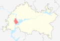
  • Location of Kamsko-Ustyinsky District (Tatarstan).svg 2,491 × 1,685; 479 KB
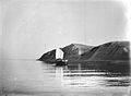
  • Богородские горы 1894.jpg 700 × 514; 68 KB
  • Религиозная карта Камско-Устинского района.png 550 × 590; 91 KB
  • Фото села.jpg 996 × 664; 100 KB
  • Этническая карта Камско-Устьинского района.png 550 × 590; 103 KB
Retrieved from "/w/index.php?title=Category:Kamsko-Ustyinsky_District&oldid=308445928"
Informasiya Melumat Axtar