Category:Irabu Island

English: Category for Irabujima (Irabu Island) in the Miyako Islands, Okinawa Prefecture, Japan
日本語: 宮古列島・伊良部島に関するカテゴリ
island in Okinawa, Japan   | |||||
| Upload media | |||||
| Instance of | |||||
|---|---|---|---|---|---|
| Part of | |||||
| Located in protected area |
| ||||
| Location | |||||
| Located in or next to body of water | |||||
| Width |
| ||||
| Length |
| ||||
| Population |
| ||||
| Area |
| ||||
| Elevation above sea level |
| ||||
 | |||||
Subcategories
This category has the following 3 subcategories, out of 3 total.
Media in category "Irabu Island"
The following 25 files are in this category, out of 25 total.
-
 Funausagibanata.jpg 960 × 1,280; 245 KB
-
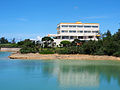
 Irabu High school 20120815.jpg 3,648 × 2,736; 4.27 MB
-
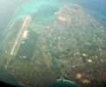
 Irabu Island and Shimoji Island Aerial photograph.2019.jpg 19,428 × 16,920; 73.66 MB
-
 Irabu island beaches (52204289053).jpg 5,988 × 3,992; 11.13 MB
-
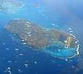
 Irabu Island ISS045.jpg 4,928 × 3,280; 1.31 MB
-
 Irabu makiyama observation platform.jpg 4,480 × 2,750; 1.68 MB
-
 Irabu makiyama tenboudai.jpg 900 × 1,200; 325 KB
-
 Irabu sarahama port sun marin terminal.jpg 1,600 × 1,200; 1.3 MB
-
 Irabu sarahama port.jpg 1,600 × 1,200; 1.36 MB
-
 Irabu yamatobu.jpg 1,200 × 1,600; 899 KB
-
 IrabuIsland.JPG 766 × 633; 139 KB
-
 Irabujima sky view.jpg 1,280 × 1,143; 166 KB
-
 KyowaBus routemap.jpg 1,320 × 1,828; 253 KB
-
 Makiyama.jpg 400 × 300; 35 KB
-
 Miyako Coral Reefs (52203264647).jpg 5,769 × 3,846; 11.81 MB
-
 Miyako coral reefs panorama (52204289173).jpg 6,922 × 3,093; 12.75 MB
-
 Miyako irabu hotel south island 2014.jpg 1,600 × 1,200; 693 KB
-
 Miyako irabujima 2013.jpg 1,600 × 1,288; 552 KB
-
 Rock photo.jpg 640 × 480; 73 KB
-
 Sarahama port.JPG 1,024 × 768; 146 KB
-
 Scenery of Irabu village in Irabu island Okinawa,JAPAN.jpg 1,600 × 1,200; 823 KB
-
 Yonaha Bay in Miyako Island.jpg 4,928 × 3,280; 1.6 MB
-
 フナウサギバナタの断崖 20130207 - panoramio.jpg 2,736 × 1,824; 3.2 MB
-
 伊良部島の座礁船 20130207 - panoramio.jpg 2,736 × 1,824; 2.67 MB
-
 復帰記念事業の石碑 20130207 - panoramio.jpg 2,736 × 1,824; 3.93 MB


.jpg)


.jpg)
.jpg)


