Category:Howe Sound
bay in British Columbia, Canada .jpg) | |||||
| Upload media | |||||
| Instance of | |||||
|---|---|---|---|---|---|
| Part of | |||||
| Location | British Columbia, Canada | ||||
| Inflows |
| ||||
 | |||||
Subcategories
This category has the following 10 subcategories, out of 10 total.
B
- Boats on Howe Sound (5 F)
- Bowyer Island (1 F)
F
- Ferries on Howe Sound (52 F)
G
- Gambier Island (12 F)
H
- Howe Sound at night (23 F)
P
- Panoramas of Howe Sound (76 F)
S
- Sunrises of Howe Sound (5 F)
- Sunsets of Howe Sound (288 F)
Media in category "Howe Sound"
The following 79 files are in this category, out of 79 total.
-
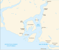 Carte baie Howe.svg 1,093 × 921; 94 KB
-
 Carte localisation de la baie Howe.png 600 × 942; 1.09 MB
-
 Howe-Sound-map,BC,Canada.png 498 × 436; 431 KB
-
 Sea to Sky Highway en.svg 1,097 × 923; 131 KB
-
 Sea to Sky Highway.svg 1,097 × 923; 131 KB
-
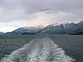
 2015 M Creek and the Howe Sound.jpg 8,796 × 3,256; 13.17 MB
-
 Autumn Storm Clouds over Howe Sound.jpg 6,400 × 9,511; 29.18 MB
-
 BC Ferry sails out of Howe Sound (5946421190).jpg 4,752 × 3,168; 2.69 MB
-
 BC Ferry sails out of Howe Sound (5946421716).jpg 4,752 × 3,168; 2.9 MB
-
 BC Sunset (377095265).jpg 1,000 × 1,504; 825 KB
-
 Bend in a lakeside road (Unsplash).jpg 9,682 × 4,803; 10.77 MB
-
 Bowyer Island.jpg 800 × 600; 53 KB
-
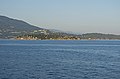
 Britannia Beach (260461069).jpeg 2,048 × 1,365; 568 KB
-
 Canada (1909) (14579127658).jpg 2,288 × 1,440; 1.14 MB
-
 Central Howe Sound looking north from Keats Island.jpg 1,280 × 901; 521 KB
-
 Cheslakee in Howe Sound.jpg 3,000 × 1,867; 584 KB
-
 Cleared the Keats visual runway 12 (525769796).jpg 2,272 × 1,704; 1.43 MB
-
 From Sea o Sky Gondola.jpg 5,472 × 3,648; 23.14 MB
-
 Furry Creek Golf ^ Country Club - panoramio.jpg 3,264 × 2,448; 2.72 MB
-
 Howe Sound (9368025090).jpg 4,000 × 3,000; 2.59 MB
-
 Howe Sound from Cypress, 1974.jpg 3,267 × 2,148; 1.19 MB
-
 Howe Sound from Horseshoe Bay (5946423510).jpg 4,752 × 3,168; 2.97 MB
-
 Howe Sound from Horseshoe Bay.jpg 6,000 × 4,000; 12.11 MB
-
 Howe Sound from Sky Pilot Mountain.jpg 3,264 × 2,448; 1.81 MB
-
 Howe Sound looking North, 1974.jpg 3,326 × 2,223; 1,020 KB
-
 Howe Sound looking north, Garibaldi.jpg 3,240 × 2,109; 1.18 MB
-
 Howe Sound sunset (3077674408).jpg 3,264 × 2,448; 2.9 MB
-
 Howe Sound, 1974 04.jpg 3,324 × 2,237; 4.59 MB
-
 Howe Sound, 1974.jpg 3,123 × 1,887; 1.33 MB
-
 Howe Sound, Anvil Island, 1974.jpg 3,267 × 2,118; 1.32 MB
-
 Howe sound, north of Vancouver (2288814281).jpg 3,423 × 2,018; 3.8 MB
-
 Howe Sound, Squamish.jpg 6,000 × 4,000; 20.69 MB
-
 Howe sound.jpg 240 × 180; 10 KB
-
 Howesound.JPG 2,272 × 1,704; 875 KB
-
 Morning after the snow - Howe Sound.jpg 12,670 × 8,228; 69.11 MB
-
 Morning after the snow - Howe Sound2.jpg 8,766 × 8,228; 39.82 MB
-
 Mount Garibaldi and Stawamus Chief.jpg 640 × 424; 163 KB
-
 Mt. Intchekai, Howe Sound - 1888.jpg 960 × 656; 201 KB
-
 North of Horseshoe Bay, Lions, 1974.jpg 3,322 × 2,225; 1.05 MB
-
 North Shore Mountains from Howe Sound.jpg 2,592 × 1,944; 592 KB
-
 Over Howe Sound (511651979).jpg 2,272 × 1,704; 1.74 MB
-
 Passage Island and West Vancouver from the ferry.jpg 5,800 × 3,832; 11.55 MB
-
 Passage Island from the ferry.jpg 6,000 × 4,000; 13.17 MB
-
 Porteau Cove (5752248265).jpg 3,648 × 2,736; 3.55 MB
-
 Porteau Cove (8050737473).jpg 5,180 × 2,088; 7.17 MB
-
 Porteau Cove 2 (8050745620).jpg 4,972 × 3,324; 6.01 MB
-
 PorteauCovePP-water-mountains.jpg 4,000 × 3,000; 3.21 MB
-
 PorteauCovePP-water.jpg 2,503 × 3,503; 1.89 MB
-
 Queen of Oak Bay in Strait of Georgia (1).jpg 6,000 × 4,000; 12 MB
-
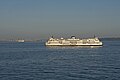 Queen of Oak Bay in Strait of Georgia (2).jpg 6,000 × 4,000; 12.06 MB
-
 Sailing out of Howe Sound, Horseshoe Bay to Nanaimo (5945753345).jpg 4,752 × 3,168; 4.38 MB
-
 Sea to Sky Highway and Howe Sound at Porteau Road.jpg 2,560 × 1,920; 1.21 MB
-
 Sea to Sky highway, BC Canada.jpg 1,920 × 1,179; 1.5 MB
-
 Snow peak on Vancouver Island.jpg 6,819 × 3,994; 19.55 MB
-
 Snowy Day - Howe Sound.jpg 9,504 × 5,202; 62.68 MB
-
 Snowy Day - Howe Sound4.jpg 9,150 × 5,132; 45.32 MB
-
 Snowy Day - Howe Sound5.jpg 8,853 × 4,998; 43.58 MB
-
 Southern tip of Passage Island from the ferry.jpg 5,816 × 3,800; 11.35 MB
-
 Squamish top of chief 2 banner.jpg 2,100 × 300; 110 KB
-
 Squamish view.jpg 4,608 × 2,592; 1.92 MB
-
 Squamish-Lillooet D.jpg 12,554 × 3,628; 12.81 MB
-
 Stawamish chief squamish.jpg 2,000 × 635; 558 KB
-
 Stawamus Chief First Peak panorama.jpg 7,495 × 1,913; 4.58 MB
-
 Stawamus Chief Provincial Park, BC (DSCF7644).jpg 4,779 × 3,253; 7.06 MB
-
 Stewart-Howe Sound.jpg 1,024 × 743; 104 KB
-
 Strait of Georgia and entrance to Howe Sound (2289593134).jpg 3,310 × 1,412; 1.66 MB
-
 The Beautiful Howe Sound (53911538088).jpg 20,391 × 5,268; 59.14 MB
-
 The Lions.jpg 3,766 × 2,160; 5.41 MB
-
 The North end of Howe Sound and Squamish, BC (3828051167).jpg 4,290 × 2,856; 13.43 MB
-
 Tug towing logs in Howe Sound, BC.jpg 3,000 × 2,000; 3.7 MB
-
 View from Gibson BC towards mainland 7402.jpg 6,000 × 2,785; 10.19 MB
-
 View from the Stawamus Chief - panoramio.jpg 3,648 × 2,052; 1.18 MB
-
 Water fall in Howe Sound.jpg 2,592 × 4,608; 5.4 MB
-
 Watts Point and Howe Sound.jpg 639 × 476; 55 KB
-
 West Vancouver from the ferry (1).jpg 6,000 × 4,000; 12.28 MB
-
 West Vancouver from the ferry (2).jpg 5,648 × 3,832; 12.56 MB
-
 West Vancouver from the ferry (3).jpg 6,000 × 4,000; 13.32 MB
-
 Woodf1a.jpg 1,200 × 1,504; 501 KB
-
 Woodf4a.jpg 819 × 638; 266 KB


.jpg)
.jpg)
.jpg)
.jpg)

.jpeg)
_(14579127658).jpg)


.jpg)


.jpg)

.jpg)


.jpg)


.jpg)


.jpg)


.jpg)
.jpg)


.jpg)
.jpg)
.jpg)


.jpg)

.jpg)


.jpg)
.jpg)
.jpg)


.jpg)
.jpg)