Category:Gulf of Corryvreckan
strait in Argyll and Bute, Scotland, UK | |||||
| Upload media | |||||
| Instance of | |||||
|---|---|---|---|---|---|
| Location | Argyll and Bute, Scotland | ||||
 | |||||

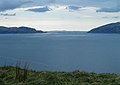
The Gulf of Corryvreckan refers to the passage between Scarba and Jura. Its shallow depths result in a higher-velocity tidal current twice a day. The topography of the bottom gives rise to the Corryvreckan whirlpool.
Subcategories
This category has the following 3 subcategories, out of 3 total.
C
- Corryvreckan whirlpool (25 F)
E
- Eilean Beag, north Jura (11 F)
- Eilean Mòr, north Jura (9 F)
Media in category "Gulf of Corryvreckan"
The following 41 files are in this category, out of 41 total.
-

-
 Admiralty Chart No 2326 Scotland west coast Loch Crinan to Cuan Sound, Published 1856.jpg 8,493 × 10,093; 11.04 MB
-
 An Cruachen, Jura - geograph.org.uk - 46142.jpg 640 × 480; 56 KB
-
 Bog, Cruach na Seilcheig - geograph.org.uk - 765150.jpg 640 × 480; 77 KB
-
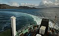 Calmac Ferry Lord of the Isles Makes a U-turn in the Gulf of Corryvrechan (6141024274).jpg 2,048 × 1,244; 2.31 MB
-

-
 Cruach Na Seilcheig - geograph.org.uk - 764922.jpg 640 × 480; 88 KB
-
 Cruach Na Seilcheig - geograph.org.uk - 764933.jpg 640 × 480; 87 KB
-
 Cruach na Seilcheig - geograph.org.uk - 992428.jpg 640 × 480; 98 KB
-
 Cruach Scarba - geograph.org.uk - 3252665.jpg 1,600 × 1,200; 515 KB
-
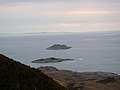
 Eilean Mor and Eilean Bearg - geograph.org.uk - 66942.jpg 640 × 441; 41 KB
-

-
 Eilean Mòr with Jura beyond - geograph.org.uk - 2394228.jpg 640 × 480; 243 KB
-

-
 Glen Trosdale - geograph.org.uk - 1237001.jpg 640 × 360; 54 KB
-
 Guano-topped outlier of Eilean Mòr - geograph.org.uk - 2394223.jpg 640 × 480; 267 KB
-
 Gulf of Corryvreckan - geograph.org.uk - 22292.jpg 640 × 480; 58 KB
-
 Gulf of Corryvreckan - geograph.org.uk - 5468188.jpg 1,024 × 769; 175 KB
-
 Gulf of Corryvreckan - geograph.org.uk - 6867971.jpg 4,469 × 2,515; 2.65 MB
-
 Gulf of Corryvreckan - panoramio.jpg 3,072 × 2,048; 1.48 MB
-

-
 Jura and Scarba.jpg 3,504 × 2,336; 7.53 MB
-
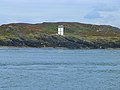 Navigation light on Rèisa an t-Struith - geograph.org.uk - 4162068.jpg 640 × 480; 419 KB
-
 North end of Eilean Beag - geograph.org.uk - 4160233.jpg 640 × 480; 406 KB
-
 North of Cruach na Seilcheig - geograph.org.uk - 992359.jpg 640 × 480; 88 KB
-
 Pillar on Cruach na Seilcheig - geograph.org.uk - 1237027.jpg 640 × 360; 43 KB
-
 Restless waters approaching the Gulf of Corryvreckan - geograph.org.uk - 8096092.jpg 1,600 × 1,067; 357 KB
-
 Rèisa an t-Struith - geograph.org.uk - 4594385.jpg 2,785 × 1,956; 1,014 KB
-
 Scarba and The Strait of Coryvreckan - geograph.org.uk - 20844.jpg 640 × 422; 49 KB
-
 The Corryvreckan from Eilean Beag - geograph.org.uk - 39359.jpg 640 × 119; 41 KB
-
 The Corryvreckan from Scarba - geograph.org.uk - 39713.jpg 1,324 × 453; 406 KB
-
 The End of the Road - geograph.org.uk - 1274505.jpg 640 × 427; 217 KB
-
 The Gulf of Corryvreckan - geograph.org.uk - 8096116.jpg 1,600 × 1,067; 450 KB
-
-
 The Paps of Jura - Flickr - Graham Grinner Lewis.jpg 2,048 × 1,536; 686 KB
-
 The tidal race in the Gulf of Corryvreckan - geograph.org.uk - 8096098.jpg 1,600 × 1,067; 393 KB
-

-
 Uamh Camas nam Bairneach on Scarba - geograph.org.uk - 2411812.jpg 640 × 421; 251 KB
-
 Walk to the Gulf of Corryvreckan - geograph.org.uk - 1451266.jpg 640 × 480; 93 KB
-
 Walking Towards An Cruachan - geograph.org.uk - 869616.jpg 640 × 360; 60 KB
-
 Western entrance to Gulf of Corryvreckan - geograph.org.uk - 1698654.jpg 1,600 × 520; 108 KB


.jpg)


