<nowiki>Imperio de Ghana; Ganaveldið; Ганайска империя; Gana İmparatorluğu; سلطنت گھانا; Ghanariket; Empèri de Ghana; 迦納帝國; 加纳帝国; 와가두 제국; Ganaa imperio; Ghanská říše; Empire du Ghana; Carstvo Gana; घानाचे साम्राज्य; Vương quốc Ghana; Ganas impērija; Царство Гана; Humambo hwe Ghana; 迦纳帝国; Ghanariket; Ghanariket; Qana İmperiyası; Ghana Empire; مملكة غانا; ߜ߭ߊ߰ߣߊ߫; 加納帝國; Gana Mansamara; Ghanako Inperioa; Imperiu de Ghana; regne de Ghana; Ymerodraeth Ghana; Гана (гістарычная дзяржава); Գանայի Թագավորություն; 迦納帝國; Ghanariget; განას იმპერია; ガーナ王国; Daular Ghana; אימפריית גאנה; Regnum Ganae; घाना साम्राज्य; 加纳帝国; Ghanan kuningaskunta; Impero del Ghana; 迦納帝國; 迦纳帝国; Ghana riik; Imbraatóor gu Gana; Ганская імпэрыя; Гана империясе; قانا ایمپیراتورلوغو; Ilẹ̀ọbalúayé Ghánà; Ghanská ríša; Império do Gana; Подшоҳии Ғано; Carstvo Gana; 加納帝國; Vagadu; Ganski imperij; Imperyo ng Ghana; Imperium Ghany; گھانا سلطنت; Kekaisaran Ghana; Dola la Ghana; Империя Гана; Koninkrijk Ghana; پادشاهی غنا; Reich von Ghana; Гана; Ufumu wa Ghana; Imperio de Ghana; Imperium vun Ghana; Inpero del Ghana; Daular Gana; ߊߝߙߌߞߌ߬ ߕߟߋ߬ߓߋ ߝߊ߰ߡߊ߬ߟߊ߫ ߞߘߐ ߣߴߊ߬ ߡߊߟߐ߲ߣߍ߲ߓߊ ߘߏ߫; ancien pays; гістарычная дзяржава; средневековое государство (империя) на западе Африки; historischer Staat; império na África Ocidental de c. 300 a c. 1100; 300 ile 1200 yılları arasında Afrika'nın batı sahillerinde hüküm sürmüş devlet; かつて西アフリカにあった王国; imperio medieval en el África Occidental; historisch land; ymerodraeth yng Ngorllewin Affrica rhwng c. 200 OC a'r 1200au; antico Stato africano (III - XIII secolo); إمبراطورية أفريقية قديمة; länsiafrikkalainen valtakunta n. 750–1235; West African empire based in modern-day Mauritania and Mali (c. 200–c. 1200s); imperio (4a–12a jarcentoj) en Afriko, nun parto de Maŭritanio kaj Malio; historický státní útvar; zahodnoafriški imperij s sedežem v današnji Mavretaniji in Maliju (ok. 200–ok. 1200-ih let); Reino de Ghana; Wagadu; Imperio Ghanés; Imperio soninké; Imperio Ghanes; Imperio soninke; Royaume du Ghana; Empire Wagadou; Empire du Ghâna; Ghana impeerium; Ghanako Erresuma; Ghana Inperioa; Вагаду; Гана; Ghana Empire; Ghana-Reich; Gana-Reich; Ghanareich; Imperium Ghana; Império de Gana; Reino do Gana; Reino de Gana; 迦納王國; 加纳帝国; 迦納; Nguuru Gana gu mag ga; Gansko cesarstvo; Gansko kraljestvo; ガーナ帝国; Wagadou; Ваґаду; Ghana Carstvo; Carstvo Ghana; Gana Carstvo; Ghana; Ghanan valtakunta; Impero Ghana; Regno di Ghana; Impero ghanese; Regno del Ghana; إمبراطورية غانة; إمبراطوريه غانا; Imperi de Ghana; Wagadou; Ganos imperija; Vagadu imperija</nowiki>
Ghana Empire
West African empire based in modern-day Mauritania and Mali (c. 200–c. 1200s)


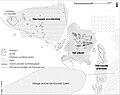 Archaeological site of Koumbi Saleh.jpg 580 × 460; 199 KB
 Central Mausoleum of the Column Tomb.jpg 580 × 521; 251 KB
 Central Mausoleum.jpg 580 × 251; 178 KB
 Ghana successor map 1200-pt.svg 610 × 431; 482 KB
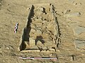 Individual Burial from the Column Tomb.jpg 580 × 435; 358 KB
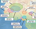 Map of ancient and Medieval Sub-Saharan states zoomed in.jpg 658 × 519; 131 KB
 Plan of the entire funerary complex of the Column Tomb.jpg 580 × 509; 155 KB
 Schematic plan of the central mausoleum.jpg 580 × 486; 132 KB
 Structural diagram of burial.jpg 543 × 945; 61 KB


