Category:Elgin, Moray
Български: Ѐлгин (на английски Elgin на гаелски Eilginn, произнася се ) е град в Североизточна Шотландия.
Čeština: Elgin je město ve Skotsku, ležící v oblasti Moray, cca 44 kilometrů východně od města Inverness. Ve městě Elgin žije necelých 21 000 obyvatel.
Deutsch: Elgin ( Gälisch: Eilginn Muireibh, was nichts anderes bedeutet als Elgin in Moray) ist mit etwa 20.580 Einwohnern (Schätzung 2004) die größte Stadt in Moray, Schottland und zugleich dessen Verwaltungssitz.
English: Elgin is a cathedral city and Royal Burgh in Moray, Scotland and is the administrative and commercial centre for Moray. The city originated to the south of the River Lossie on the higher ground above the flood plain. Elgin is first documented in the Cartulary of Moray in 1190. It was created a Royal Burgh in the 12th century by King David I of Scotland and by that time had a castle on top of the present day Lady Hill to the west of the city.
Español: Elgin ( gaélico: Eilginn) es una antigua ciudad catedralicia y antiguo Burgo Real en el area de Moray. La ciudad se creó al sur del rio Lossie, en una zona elevada. Elgin es documentada por primera vez en el Capítulo de Moray en 1190. Fue denominada Burgo Real en el Siglo XII por el rey David I de Escocia.
Suomi: Elgin on kylä Skotlannissa, jonkin verran etelään Lossiemouthista. Pääteollisuus alueella on villa.
Français : Elgin est une ville de la région de Moray, dont c'est la capitale économique et administrative. Elle a été fondée au .
Gàidhlig: 'S e baile ann an Alba a tuath a tha ann an Eilginn. Tha e ann an Siorrachd Mhoireibh agus tha prìomh-oifis Comhairle Mhoireibh ann.
Italiano: Elgin (Eilginn in gaelico scozzese) è una cittadina della Scozia Nord orientale, situata a 35 miglia (55 km) ad est di Inverness e 60 miglia (95 km) ad ovest di Aberdeen. La principale attività industriale della zona è la produzione di whisky, grazie alle numerose distillerie site nell'area dello Speyside. La città, cui spetta il titolo onorifico di Royal Burgh, è il capoluogo amministrativo dell'area consigliare del Moray e il capoluogo storico della contea tradizionale dell'Elginshire, detta anche Morayshire.
Nederlands: Elgin (Eilginn) is een plaats en voormalige burgh in het Schotse bestuurlijke gebied Moray en telt ongeveer 26.000 inwoners. De plaats ligt ten zuiden van de rivier Lossie op de hoger gronden boven het vloedniveau. Elgin wordt het eerst genoemd in 1190 in Chatulary of Moray .
Norsk bokmål: Elgin ( skotsk gælisk Eilginn) er en by i Moray i nordre Skottland i Storbritannia. Byen ligger ved elven Lossie og har 20 700 innbyggere (2004), og den fremste industrien er whiskyfremstilning.
Polski: Elgin ( gael. Eilginn) - miasto w Wielkiej Brytanii, w Szkocji. Centrum administracyjne hrabstwa Moray. W 2001 liczyło 25 678 mieszkańców.
Русский: Элгин — город в Шотландии, административный центр области Морей. Город разделен на два района — Северный Элгин и Южный Элгин.
Scots: Elgin is a ceety in the Scots coonty of Moray. Its raither wee realy, but it haes ceety status acaus it haes a cathedral.
Svenska: Elgin ( skotsk gäliska Eilginn) är en stad i Moray i norra Skottland i Storbritannien. Staden är belägen vid floden Lossie och har 20 580 invånare (2004). Den främsta industrin är whiskyframställning.
former cathedral city and Royal Burgh in Moray, Scotland, UK   | |||||
| Upload media | |||||
| Instance of |
| ||||
|---|---|---|---|---|---|
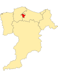
| Location |
| ||||
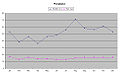
| Population |
| ||||
| official website | |||||
 | |||||
Subcategories
This category has the following 36 subcategories, out of 36 total.
A
B
- Borough Briggs (7 F)
- Braco's Banking House (7 F)
C
- Convent of Mercy, Elgin (13 F)
D
- Dr Gray's Hospital, Elgin (13 F)
E
- Elgin (East) railway station (15 F)
- Elgin Biblical Garden (27 F)
- Elgin Castle (7 F)
- Elgin fountain (20 F)
- St Giles Kirk, Elgin (31 F)
- Elgin High Kirk (2 F)
- Elgin Museum, Moray (12 F)
- Elgin railway station (27 F)
- Elgin Sheriff Court (2 F)
- Elgin Town Hall, Moray (11 F)
J
L
- Little Cross, Elgin (7 F)
M
- Moray College (7 F)
- Moray Motor Museum (10 F)
- Muckle Cross, Elgin (9 F)
P
- Pans Port, Elgin (5 F)
S
- South Kirk, Elgin (7 F)
T
Media in category "Elgin, Moray"
The following 200 files are in this category, out of 1,314 total.
(previous page) (next page)-
-
 "Picking up" on the banks of the Lossie - geograph.org.uk - 602646.jpg 640 × 426; 175 KB
-
 'Coral Boulders' - geograph.org.uk - 868374.jpg 640 × 440; 289 KB
-
 15 High Street Elgin.jpg 4,080 × 3,072; 1.62 MB
-
 2008 Elgin (3998780459).jpg 2,272 × 1,704; 703 KB
-
 2018 07 10 Schottland (35).jpg 4,000 × 3,000; 5 MB
-
 25 - 27 High Street - geograph.org.uk - 366984.jpg 640 × 421; 269 KB
-
 30mph at Carron - geograph.org.uk - 1454261.jpg 640 × 481; 151 KB
-
 54 High Street Elgin.jpg 4,080 × 3,072; 1.13 MB
-
 A "Flanker" east of Bodnastalker - geograph.org.uk - 602551.jpg 640 × 426; 85 KB
-
 A Bench with a View - geograph.org.uk - 1746626.jpg 640 × 427; 270 KB
-
 A bridge to concentrate on by Auchlochan - geograph.org.uk - 545391.jpg 426 × 640; 134 KB
-
 A Buccaneer at the Service Station - geograph.org.uk - 820352.jpg 640 × 442; 57 KB
-
 A Buccaneer in the forecourt - geograph.org.uk - 3891991.jpg 640 × 421; 174 KB
-
 A Bull at Castle Grant Home Farm - geograph.org.uk - 588696.jpg 640 × 480; 174 KB
-

-

-

-
-
-
-

-
 A rainy day on the approach to Dava - geograph.org.uk - 566948.jpg 640 × 426; 81 KB
-
-
-

-

-
 A view of the northern shore of Loch Noir - geograph.org.uk - 592804.jpg 640 × 426; 114 KB
-

-

-
 A941 entering Elgin - geograph.org.uk - 1528323.jpg 640 × 430; 39 KB
-
 Abandoned croft of Auchlochan. - geograph.org.uk - 545526.jpg 640 × 426; 122 KB
-
 Above Curlusk - geograph.org.uk - 415262.jpg 640 × 427; 278 KB
-
 Access to Newseat Farm - geograph.org.uk - 1033264.jpg 640 × 480; 157 KB
-
 Access to Scurdargue Cottages - geograph.org.uk - 1033295.jpg 640 × 480; 133 KB
-
 Access to Tap O'Noth car park - geograph.org.uk - 1033298.jpg 640 × 388; 90 KB
-
 Achbreck is not derelict - geograph.org.uk - 638576.jpg 640 × 480; 77 KB
-
 Aerial to the sou'east of Loch Trevie - geograph.org.uk - 593109.jpg 426 × 640; 110 KB
-
 Allt na ceardaich to the east. - geograph.org.uk - 547369.jpg 640 × 426; 92 KB
-
 Allt na h-Eirghe - geograph.org.uk - 471363.jpg 640 × 480; 112 KB
-
-

-
 Ancient sheep pen south of Aittendow. - geograph.org.uk - 547396.jpg 640 × 426; 97 KB
-
 Anderson's Institution, Elgin - geograph.org.uk - 1287939.jpg 640 × 479; 55 KB
-
 Another entrance to Clashindarroch - geograph.org.uk - 1034322.jpg 640 × 480; 129 KB
-
 Approach to Belhinnie - geograph.org.uk - 1033707.jpg 640 × 480; 63 KB
-
 Approach to Cowford Bridge - geograph.org.uk - 1034250.jpg 640 × 480; 95 KB
-
 Approach to Redford - geograph.org.uk - 1019178.jpg 640 × 480; 80 KB
-
 Ardoch Wood - geograph.org.uk - 415114.jpg 640 × 427; 276 KB
-
 Around Elgin, Moray (200592) (9461623369).jpg 4,348 × 2,726; 2.65 MB
-
 Aspire - geograph.org.uk - 373824.jpg 640 × 532; 268 KB
-
 Aswanley - geograph.org.uk - 1434851.jpg 640 × 480; 43 KB
-
 At the edge of the moor. - geograph.org.uk - 399749.jpg 640 × 480; 84 KB
-
 Auchinhandock - geograph.org.uk - 380859.jpg 640 × 480; 79 KB
-
 Autumnal beauty of Loch Dallas - geograph.org.uk - 584447.jpg 640 × 426; 112 KB
-
 Banking House - Cloud Nine, Elgin - geograph.org.uk - 1287990.jpg 640 × 479; 61 KB
-
 Bardonside - geograph.org.uk - 388123.jpg 640 × 367; 214 KB
-
 Barley field, Carnach - geograph.org.uk - 526796.jpg 640 × 509; 66 KB
-
 Barluack - geograph.org.uk - 384754.jpg 640 × 427; 255 KB
-
 Barluack - geograph.org.uk - 384762.jpg 640 × 427; 245 KB
-
 Barluack - geograph.org.uk - 384764.jpg 640 × 293; 159 KB
-
 Barluack - geograph.org.uk - 384765.jpg 640 × 246; 138 KB
-
 Barluack - geograph.org.uk - 384777.jpg 640 × 427; 269 KB
-
 Barmuckity Railway Bridge. - geograph.org.uk - 182641.jpg 640 × 427; 106 KB
-

-
 Belnellan - geograph.org.uk - 532633.jpg 640 × 427; 243 KB
-
 Berryhillock Bus Stop - geograph.org.uk - 483470.jpg 640 × 395; 235 KB
-
 Bilbohall - geograph.org.uk - 225810.jpg 640 × 260; 138 KB
-

-
 Bishopmill Bridge.jpg 4,080 × 3,072; 1.42 MB
-
 Blaeberry Flowers - geograph.org.uk - 415062.jpg 640 × 587; 360 KB
-
 Boat of Aikenway - geograph.org.uk - 707409.jpg 640 × 421; 293 KB
-
 Bogeney nestles in the trees. - geograph.org.uk - 545174.jpg 640 × 426; 123 KB
-
 Bogs of Mayne Memorial near Elgin - geograph.org.uk - 101031.jpg 640 × 480; 160 KB
-
 Bogs of Mayne Memorial near Elgin - geograph.org.uk - 121216.jpg 640 × 480; 83 KB
-
 Brawlands - geograph.org.uk - 422139.jpg 640 × 398; 207 KB
-
 Bridge of Brown - geograph.org.uk - 776247.jpg 640 × 359; 49 KB
-
 Bridge over Burn Treble - geograph.org.uk - 380928.jpg 640 × 480; 88 KB
-
 Bridge over the Katharane How - geograph.org.uk - 381210.jpg 640 × 480; 119 KB
-
 Bridge over the River Lossie - geograph.org.uk - 1068886.jpg 640 × 480; 101 KB
-
 Bridge over the River Lossie - geograph.org.uk - 1068889.jpg 640 × 480; 100 KB
-
 Bridgehaugh cottage - geograph.org.uk - 380892.jpg 640 × 480; 124 KB
-
 Broadfield - geograph.org.uk - 415449.jpg 640 × 427; 201 KB
-
 Buccaneer Service Station - geograph.org.uk - 2075453.jpg 640 × 282; 156 KB
-
 Burnpark Wood - geograph.org.uk - 415475.jpg 427 × 640; 278 KB
-
 Burnpark Wood - geograph.org.uk - 415479.jpg 427 × 640; 326 KB
-
 Burntreble Farm - geograph.org.uk - 380969.jpg 640 × 480; 100 KB
-
 By the Dismantled Railway at Elgin - geograph.org.uk - 1458100.jpg 640 × 430; 67 KB
-
 Bypassed Bridge - geograph.org.uk - 1393492.jpg 640 × 427; 115 KB
-

-
 Carn Daimh - geograph.org.uk - 430287.jpg 640 × 480; 81 KB
-
 Carnach Wood - geograph.org.uk - 526800.jpg 640 × 480; 121 KB
-
 Carnach Wood - geograph.org.uk - 526802.jpg 640 × 480; 99 KB
-
 Cattle at Drodland - geograph.org.uk - 413861.jpg 640 × 427; 255 KB
-
 Caysbriggs Quarry, Morayshire. - geograph.org.uk - 191623.jpg 640 × 427; 82 KB
-
 Chair in the air - geograph.org.uk - 642857.jpg 480 × 640; 68 KB
-

-

-

-
 Clunybeg cottage - geograph.org.uk - 394750.jpg 640 × 480; 103 KB
-
 Coming or going^ - geograph.org.uk - 247735.jpg 640 × 480; 102 KB
-
 Compact tractor - geograph.org.uk - 380130.jpg 640 × 480; 153 KB
-
 Contrasting Gardens - geograph.org.uk - 1293735.jpg 640 × 427; 280 KB
-
 Cooper Park Bowling Green, Elgin - geograph.org.uk - 1287631.jpg 640 × 479; 55 KB
-
 Craigbegg Smithy Cottage - geograph.org.uk - 552045.jpg 640 × 426; 158 KB
-
 Crises time at Elgin. - geograph.org.uk - 1473237.jpg 640 × 427; 94 KB
-

-
 Cuttieshillock Quarry.jpg 640 × 427; 519 KB
-
 Descent to Blackwater bridge - geograph.org.uk - 381032.jpg 640 × 480; 77 KB
-

-

-
 Down but by no means out^ - geograph.org.uk - 545530.jpg 640 × 426; 136 KB
-
 Drodland - geograph.org.uk - 413807.jpg 640 × 427; 277 KB
-
 Duke of Gordon's Monument - geograph.org.uk - 3180799.jpg 3,264 × 2,448; 1.29 MB
-
 Easter Monday primroses at Covesea. - geograph.org.uk - 394278.jpg 640 × 426; 167 KB
-
 Edge of Abernethy Forest - near Lurg - geograph.org.uk - 522136.jpg 640 × 480; 76 KB
-
 Elchies House, Elgin (1887) (14778801941).jpg 1,816 × 2,154; 521 KB
-
 Elgin (Location) Modified.png 553 × 933; 180 KB
-
 Elgin - Council Offices (15182141468).jpg 5,439 × 3,626; 5.27 MB
-
 Elgin - Council Offices (15182217657).jpg 5,472 × 3,648; 2.81 MB
-
 Elgin - Fife Arms Close to St Giles Church (15368712365).jpg 3,545 × 5,318; 3.37 MB
-
 Elgin - Grand Hotel (15365553161).jpg 5,256 × 3,218; 3.5 MB
-
 Elgin - Harrow Inn Close (15345699476).jpg 3,648 × 5,472; 5.26 MB
-
 Elgin - Marriage Stone (15368401032).jpg 5,472 × 3,648; 8.17 MB
-
 Elgin - The Picture House (15182198557).jpg 3,648 × 5,472; 3.75 MB
-
 Elgin - The Picture House (15345702816).jpg 3,648 × 5,472; 4.83 MB
-
 Elgin - The Wolf - geograph.org.uk - 8113054.jpg 3,864 × 5,152; 3.57 MB
-
 Elgin - Thunderton House (15182186787).jpg 3,641 × 3,641; 4.11 MB
-
 Elgin Academy - geograph.org.uk - 244973.jpg 640 × 481; 82 KB
-
 Elgin age structure.jpg 977 × 600; 54 KB
-
 Elgin Ambulance Station - geograph.org.uk - 1365986.jpg 640 × 427; 54 KB
-
 Elgin Bowling Club - geograph.org.uk - 1365895.jpg 640 × 427; 46 KB
-
 Elgin Bowling Club - geograph.org.uk - 809955.jpg 640 × 406; 41 KB
-
 Elgin Bus Station - geograph.org.uk - 4230501.jpg 640 × 415; 64 KB
-
 Elgin City North.svg 1,054 × 1,276; 37 KB
-
 Elgin City South.svg 1,054 × 1,276; 37 KB
-
 Elgin country birth.jpg 977 × 600; 57 KB
-
 Elgin Free Kirk - geograph.org.uk - 1284516.jpg 543 × 640; 292 KB
-
 Elgin From Above - geograph.org.uk - 936834.jpg 640 × 480; 87 KB
-
 Elgin Golf Club - geograph.org.uk - 820277.jpg 640 × 480; 60 KB
-
 Elgin Golf Club - geograph.org.uk - 820397.jpg 640 × 558; 83 KB
-
 Elgin Golf Club - geograph.org.uk - 820403.jpg 640 × 480; 131 KB
-
 Elgin Highland Games - geograph.org.uk - 367368.jpg 640 × 389; 183 KB
-
 Elgin Highland Games - geograph.org.uk - 367369.jpg 640 × 422; 233 KB
-
 Elgin Highland Games - geograph.org.uk - 367372.jpg 640 × 393; 218 KB
-
 Elgin M O T Centre - geograph.org.uk - 1293666.jpg 640 × 409; 199 KB
-
 Elgin population.jpg 977 × 600; 37 KB
-
 Elgin rainfall.jpg 977 × 600; 65 KB
-
 Elgin religion.jpg 977 × 600; 62 KB
-
 Elgin temperature.jpg 977 × 600; 105 KB
-
 ElginScotland.jpeg 3,888 × 2,592; 4.2 MB
-
 Elginshill - geograph.org.uk - 201860.jpg 640 × 374; 221 KB
-

-
 Entrance to Lesmurdie House - geograph.org.uk - 1066843.jpg 640 × 420; 114 KB
-
 Esker, Cnocan-a-Bealaidh - geograph.org.uk - 525281.jpg 640 × 480; 115 KB
-
 Farm Machinery - geograph.org.uk - 225831.jpg 640 × 427; 264 KB
-
 Farm trailer - geograph.org.uk - 380132.jpg 640 × 480; 109 KB
-
 Farmland near Easter Manbeen - geograph.org.uk - 106169.jpg 640 × 427; 75 KB
-
 Farmland near Miltonduff - geograph.org.uk - 135329.jpg 640 × 427; 100 KB
-
 Farmland near Palmerscross - geograph.org.uk - 135328.jpg 640 × 427; 96 KB
-

-
 Fill her up please^ - geograph.org.uk - 3892007.jpg 640 × 427; 188 KB
-
 Fire Station, Elgin - geograph.org.uk - 4083605.jpg 640 × 480; 50 KB
-
 Fleabane^ - geograph.org.uk - 415401.jpg 640 × 510; 230 KB
-

-
 Flower, fruit and vegetables in Tesco, Elgin - geograph.org.uk - 5620775.jpg 559 × 1,024; 180 KB
-
 Footbridge over the River Divie. - geograph.org.uk - 455142.jpg 640 × 458; 203 KB
-
 Ford Across the Milk Burn - geograph.org.uk - 413793.jpg 427 × 640; 257 KB
-
 Forest Fence - geograph.org.uk - 399770.jpg 640 × 427; 247 KB
-
 Former Drill Hall - geograph.org.uk - 3921603.jpg 640 × 429; 357 KB
-
 Former Railway Line - geograph.org.uk - 712263.jpg 640 × 427; 275 KB
-

-
 From Hill of Spynie. - geograph.org.uk - 16095.jpg 640 × 426; 39 KB
-
 Frozen Field - geograph.org.uk - 1062413.jpg 427 × 640; 260 KB
-
 Fungi (species unknown) - geograph.org.uk - 594639.jpg 640 × 416; 213 KB
-
 Fungi (species unknown) - geograph.org.uk - 594698.jpg 640 × 286; 189 KB
-

-
 Gatehouse to Dunphail Estate. - geograph.org.uk - 369977.jpg 640 × 426; 121 KB
-
 Gateside - geograph.org.uk - 415156.jpg 640 × 427; 272 KB
-
 Gateside - geograph.org.uk - 415162.jpg 640 × 296; 163 KB
-
 Gateside - geograph.org.uk - 415169.jpg 640 × 427; 265 KB
-
 Gateside - geograph.org.uk - 415181.jpg 640 × 427; 247 KB
-
 Geographers meet^ - geograph.org.uk - 1287962.jpg 640 × 479; 54 KB
-

-

-
 Glenheath - geograph.org.uk - 532587.jpg 640 × 427; 270 KB
-
 Glenheath - geograph.org.uk - 532590.jpg 640 × 427; 279 KB
-
 Glenlatterach Reservoir - geograph.org.uk - 398602.jpg 640 × 427; 243 KB
-
 Glenlivet Estate - geograph.org.uk - 453517.jpg 640 × 480; 94 KB
-
 Glenlivet Estate waymark - geograph.org.uk - 430469.jpg 640 × 480; 101 KB
-
 Goldenknowes - geograph.org.uk - 415417.jpg 640 × 427; 288 KB
-
 Goldenknowes - geograph.org.uk - 415421.jpg 640 × 427; 269 KB
-
 Gordon Street - geograph.org.uk - 1062403.jpg 640 × 427; 219 KB
-
 Grampian Property Centre, Elgin - geograph.org.uk - 1288008.jpg 640 × 479; 59 KB
-

-

-
 Hill of Bellyhack - geograph.org.uk - 433528.jpg 640 × 427; 270 KB
-
 Hill of Meft - geograph.org.uk - 16104.jpg 640 × 480; 110 KB
-
 Husband Creche at Thunderton House - geograph.org.uk - 1004719.jpg 427 × 640; 264 KB
-
 Islet to the north of Loch Dallas - geograph.org.uk - 584456.jpg 640 × 426; 102 KB


.jpg)
.jpg)


_(9461623369).jpg)


_-_geograph.org.uk_-_478064.jpg)


_(14778801941).jpg)
_Modified.png)
.jpg)
.jpg)
.jpg)
.jpg)
.jpg)
.jpg)
.jpg)
.jpg)

.jpg)


_-_geograph.org.uk_-_594639.jpg)
_-_geograph.org.uk_-_594698.jpg)


