Category:Dionay
former commune in Isère, France   | |||||
| Upload media | |||||
| Instance of |
| ||||
|---|---|---|---|---|---|
| Location |
| ||||
| Dissolved, abolished or demolished date |
| ||||
| Population |
| ||||
| Area |
| ||||
| Elevation above sea level |
| ||||
| Replaced by | |||||
| official website | |||||
 | |||||
Subcategories
This category has the following 3 subcategories, out of 3 total.
Media in category "Dionay"
The following 15 files are in this category, out of 15 total.
-
 Dionay, Isère, France, OSM.png 1,081 × 553; 282 KB
-
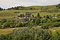 Dionay.JPG 4,288 × 2,848; 8.5 MB
-
 Mairie de Dionay, Isère .jpg 4,128 × 3,096; 3.36 MB
-
 Map commune FR insee code 38145.png 756 × 605; 45 KB
-
 Monument aux morts de Dionay .jpg 3,096 × 4,128; 3.49 MB
-
 Monument aux morts de Dionay 2.jpg 3,096 × 4,128; 3.16 MB
-
 Monument aux morts de Dionay 3.jpg 3,096 × 4,128; 5.2 MB
-
 Monument aux morts de Dionay 4.jpg 3,096 × 4,128; 4.85 MB
-
 Panorama près de Dionay .jpg 4,128 × 3,096; 4.39 MB
-
 Poney, près de Dionay, Isère .jpg 4,128 × 3,096; 5.33 MB
-
 Poney, près de Dionay, Isère 2.jpg 4,128 × 3,096; 6.8 MB
-
 Poney, près de Dionay, Isère 3.jpg 4,128 × 3,096; 6.69 MB
-
 Poney, près de Dionay, Isère 4.jpg 3,096 × 4,128; 3.5 MB
-
 Population - Municipality code 38145.svg 475 × 355; 12 KB
-
 Saint-Antoine EM 1866 small.jpg 2,064 × 2,972; 8.1 MB


