Category:Crawley
town in West Sussex, England, United Kingdom  | |||||
| Upload media | |||||
| Instance of | |||||
|---|---|---|---|---|---|
| Location | Crawley, West Sussex, South East England, England | ||||
| Population |
| ||||
| Area |
| ||||
| official website | |||||
 | |||||
Subcategories
This category has the following 23 subcategories, out of 23 total.
- Blue plaques in Crawley (27 F)
- Maps of Crawley (37 F)
B
- Benchmarks in Crawley (19 F)
- Bridges in Crawley (50 F)
- Bridleways in Crawley (49 F)
F
- Public footpaths in Crawley (239 F)
H
S
- Snow in Crawley (24 F)
T
- The Gym Group, Crawley (empty)
Media in category "Crawley"
The following 200 files are in this category, out of 2,774 total.
(previous page) (next page)-
 'Authorised vehicles only' but blocked anyway - geograph.org.uk - 7154114.jpg 1,024 × 771; 678 KB
-
 'Authorised vehicles only' by M23 junction 9 - geograph.org.uk - 7180162.jpg 1,024 × 771; 471 KB
-
 'Cat' on footbridge over railway - geograph.org.uk - 7187182.jpg 1,024 × 771; 498 KB
-
 'New homes coming soon', Crawley - geograph.org.uk - 6321667.jpg 1,024 × 1,024; 289 KB
-
 'Next tee', Goffs Park pitch and putt - geograph.org.uk - 8137353.jpg 1,024 × 771; 623 KB
-
 'Orleton Lodge', Goffs Park Road - geograph.org.uk - 4689192.jpg 1,024 × 683; 195 KB
-
 'Smile more' - geograph.org.uk - 6455501.jpg 1,024 × 1,024; 603 KB
-

-
 'Welcome to the New Lagoon Conservation Area' - geograph.org.uk - 7017860.jpg 1,024 × 768; 390 KB
-
 1 City Place, Gatwick - geograph.org.uk - 1676717.jpg 640 × 480; 79 KB
-
 126 - 134 (even) Heathfield, Pound Hill, Crawley - geograph.org.uk - 6745251.jpg 1,024 × 684; 260 KB
-
 17 and 19 Brighton Road, Crawley - geograph.org.uk - 3596196.jpg 640 × 428; 89 KB
-
 18dqu072.tif 3,702 × 5,553; 58.85 MB
-
 191 Three Bridges Road, Three Bridges, Crawley - geograph.org.uk - 6776746.jpg 1,024 × 684; 256 KB
-
 1985 London to Brighton Veteran Car Run (1) - geograph.org.uk - 3209511.jpg 1,799 × 1,215; 2.38 MB
-
 2 City Place, Gatwick - geograph.org.uk - 1676730.jpg 640 × 480; 57 KB
-

-
 23 Gales Place, Three Bridges, Crawley - geograph.org.uk - 6777136.jpg 1,024 × 684; 320 KB
-
 2nd Ifield (St Margaret's) Scout Group - geograph.org.uk - 7185705.jpg 1,024 × 771; 569 KB
-
 387119 at Gatwick Airport - geograph.org.uk - 8141117.jpg 1,024 × 768; 185 KB
-
 4th Worth Scout Hall - geograph.org.uk - 7204610.jpg 1,600 × 992; 676 KB
-
 5th Crawley Scout Group hut - geograph.org.uk - 6777103.jpg 1,024 × 684; 330 KB
-
 70 years of Crawley New Town - geograph.org.uk - 5532832.jpg 1,000 × 662; 1.11 MB
-
 A 5 acre site^ - geograph.org.uk - 1650656.jpg 640 × 428; 86 KB
-
 A branch of Lytton Drive, Pound Hill, Crawley - geograph.org.uk - 6751055.jpg 1,024 × 768; 402 KB
-

-
 A busy Turners Hill Road at M23 bridge - geograph.org.uk - 6139094.jpg 1,024 × 768; 221 KB
-
 A caged footpath - geograph.org.uk - 7014923.jpg 1,024 × 768; 430 KB
-

-

-
 A corner of Worth Park - geograph.org.uk - 8063242.jpg 1,024 × 771; 349 KB
-
 A disgraced nursing home - geograph.org.uk - 3594370.jpg 640 × 480; 136 KB
-
 A fine specimen^ - geograph.org.uk - 7240198.jpg 684 × 1,024; 316 KB
-
 A glimpse of houses, Charman Gardens, Ifield - geograph.org.uk - 7135494.jpg 1,024 × 768; 490 KB
-
 A glimpse of the railway, Forge Wood - geograph.org.uk - 7300016.jpg 1,024 × 771; 572 KB
-
-
 A leafy view, The Ridings, Pound Hill, Crawley - geograph.org.uk - 7354399.jpg 1,024 × 771; 644 KB
-
 A load of estate agents boards - geograph.org.uk - 6779912.jpg 1,024 × 768; 351 KB
-
 A macabre decoration for an osteopathy business - geograph.org.uk - 6778479.jpg 1,024 × 768; 335 KB
-
 A misty morning at the airport hotel - geograph.org.uk - 6074768.jpg 2,000 × 1,333; 1.86 MB
-
 A moss, Tilgate Park - geograph.org.uk - 7826991.jpg 1,024 × 771; 531 KB
-
 A room with a view - geograph.org.uk - 4994893.jpg 4,014 × 2,972; 3.34 MB
-
 A tee, Goffs Park pitch and putt course - geograph.org.uk - 8137537.jpg 1,024 × 771; 450 KB
-
-
-
 A watery view, Bewbush, Crawley - geograph.org.uk - 1642474.jpg 640 × 428; 173 KB
-

-
 A way onto Ifield Green - geograph.org.uk - 7154465.jpg 1,024 × 771; 691 KB
-
 A way out of Maidenbower Park - geograph.org.uk - 6538566.jpg 1,024 × 768; 407 KB
-
 A way out of Waterlea Meadow LNR - geograph.org.uk - 6098200.jpg 1,024 × 768; 546 KB
-
 A way out of Woldhurstlea Wood - geograph.org.uk - 7178094.jpg 1,024 × 771; 770 KB
-
 A white hedgerow, Ifield Brook Meadows - geograph.org.uk - 7136324.jpg 1,024 × 768; 382 KB
-
 A2004 Northgate Avenue, Crawley - geograph.org.uk - 6777339.jpg 1,024 × 768; 562 KB
-
 A2004 Southgate Avenue, Crawley - geograph.org.uk - 6101036.jpg 1,024 × 768; 208 KB
-
 A2004 Southgate Avenue, Crawley - geograph.org.uk - 6772483.jpg 1,024 × 768; 440 KB
-
 A2004 Southgate Avenue, Crawley - geograph.org.uk - 6774318.jpg 1,024 × 768; 494 KB
-
 A2004, Crawley - geograph.org.uk - 2941308.jpg 640 × 430; 59 KB
-
 A2011 bridge over Balcombe Road (B2036) - geograph.org.uk - 8020935.jpg 800 × 518; 146 KB
-
 A2011 Crawley Avenue - geograph.org.uk - 6779471.jpg 1,024 × 768; 405 KB
-
 A2219 - geograph.org.uk - 6504937.jpg 1,024 × 684; 156 KB
-
 A2219 Brighton Road, Crawley - geograph.org.uk - 6773028.jpg 1,024 × 768; 387 KB
-
 A2219 Brighton Road, Crawley - geograph.org.uk - 6773144.jpg 1,024 × 768; 517 KB
-
 A2219 Brighton Road, Crawley - geograph.org.uk - 6773159.jpg 1,024 × 768; 609 KB
-
 A2219 Brighton Road, Crawley - geograph.org.uk - 6773166.jpg 1,024 × 768; 617 KB
-
 A2220 Horsham Road, Southgate, Crawley - geograph.org.uk - 6773681.jpg 1,024 × 768; 559 KB
-
 A2220 Horsham Road, Southgate, Crawley - geograph.org.uk - 6773693.jpg 1,024 × 768; 606 KB
-
 A2220 Worth Park Avenue, Pound Hill, Crawley - geograph.org.uk - 6739356.jpg 1,024 × 768; 446 KB
-
 A2220 Worth Park Avenue, Pound Hill, Crawley - geograph.org.uk - 6739367.jpg 1,024 × 768; 465 KB
-
 A2220 Worth Park Avenue, Pound Hill, Crawley - geograph.org.uk - 6739371.jpg 1,024 × 768; 501 KB
-
 A2220 Worth Park Avenue, Pound Hill, Crawley - geograph.org.uk - 6759697.jpg 1,024 × 768; 358 KB
-
 A23 bridge over the River Mole - geograph.org.uk - 3678375.jpg 640 × 480; 122 KB
-
 Access road at Gatwick Airport - geograph.org.uk - 4330463.jpg 640 × 480; 83 KB
-
 Access to Gatwick Airport from M23 - geograph.org.uk - 1175527.jpg 640 × 442; 75 KB
-
 Access track to Ballast Hole - geograph.org.uk - 5838913.jpg 1,024 × 768; 459 KB
-
 Access track to Ballast Hole - geograph.org.uk - 5838917.jpg 1,024 × 768; 496 KB
-
 Acorns, Goffs Park - geograph.org.uk - 8137288.jpg 1,024 × 1,024; 562 KB
-

-
 Across the end of Sandpiper Court - geograph.org.uk - 4883755.jpg 800 × 600; 163 KB
-
 Advertisement at Gatwick Airport - geograph.org.uk - 4330493.jpg 640 × 480; 82 KB
-
 Aerotron, Westley House, Fleming Way, Crawley - geograph.org.uk - 6747145.jpg 1,024 × 684; 320 KB
-
 Aerotron, Westley House, Fleming Way, Crawley - geograph.org.uk - 6778739.jpg 1,024 × 684; 283 KB
-
 Air Training Corps 19 (Crawley) Squadron - geograph.org.uk - 7185708.jpg 1,024 × 771; 596 KB
-
 Airborne above the M23 - geograph.org.uk - 1873557.jpg 640 × 427; 143 KB
-

-
 Aircraft at gate 113 - geograph.org.uk - 7830421.jpg 576 × 1,024; 126 KB
-
 Aircraft over the car park - geograph.org.uk - 7830418.jpg 1,024 × 900; 563 KB
-

-
 Airline advertisement at Gatwick Airport - geograph.org.uk - 4925644.jpg 800 × 600; 144 KB
-
 Alfred Close, Maidenbower, Crawley - geograph.org.uk - 6843118.jpg 1,024 × 684; 338 KB
-
 Alley behind Northgate Road, Crawley - geograph.org.uk - 3596533.jpg 640 × 480; 145 KB
-

-
 Alley, Bewbush, Crawley - geograph.org.uk - 3615499.jpg 640 × 480; 128 KB
-
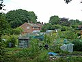
 Allotments behind Baker Close - geograph.org.uk - 2795532.jpg 640 × 430; 89 KB
-
 Allotments by the Worth Way - geograph.org.uk - 3666819.jpg 640 × 430; 106 KB
-
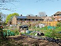
 Allotments off Malthouse Rd - geograph.org.uk - 2795529.jpg 640 × 430; 63 KB
-
 Allotments, Pound Hill, Crawley - geograph.org.uk - 3589486.jpg 640 × 480; 122 KB
-
 Allotments, Pound Hill, Crawley - geograph.org.uk - 5744597.jpg 640 × 480; 157 KB
-
-
 Alpaca paddock, Tilgate Nature Centre - geograph.org.uk - 7324147.jpg 1,024 × 771; 785 KB
-
-
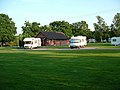
 Amberley Fields Caravan Club site, from the air - geograph.org.uk - 4135577.jpg 1,600 × 1,064; 309 KB
-
 An open area, Wakehurst Drive - geograph.org.uk - 2798100.jpg 640 × 430; 70 KB
-
 Ancient and modern with gull - geograph.org.uk - 2750605.jpg 800 × 592; 243 KB
-
 Anglers' parking area - geograph.org.uk - 5838227.jpg 1,024 × 768; 380 KB
-
 Antlands Lane (B2037) - geograph.org.uk - 8020917.jpg 800 × 571; 177 KB
-
 Apology not accepted.... - geograph.org.uk - 4867069.jpg 800 × 600; 128 KB
-
 Apple Green Service Station, Crawley Avenue - geograph.org.uk - 3254878.jpg 1,388 × 1,039; 820 KB
-
 Apples on the path - geograph.org.uk - 7014789.jpg 1,024 × 768; 542 KB
-
 Approaching Junction 9 - geograph.org.uk - 8165002.jpg 1,024 × 683; 131 KB
-
 Approaching Lowfield Heath - geograph.org.uk - 1968176.jpg 640 × 428; 110 KB
-

-

-
 Arden Road, Furnace Green, Crawley - geograph.org.uk - 5521107.jpg 640 × 428; 145 KB
-
 Area with benches, Forge Wood, Crawley - geograph.org.uk - 7299898.jpg 1,024 × 771; 546 KB
-
 Art under A2011 Crawley Avenue - geograph.org.uk - 6746842.jpg 1,024 × 768; 335 KB
-
 Art under A2011 Crawley Avenue - geograph.org.uk - 6746848.jpg 1,024 × 768; 341 KB
-
 Art under A2011 Crawley Avenue - geograph.org.uk - 6746853.jpg 1,024 × 768; 349 KB
-
 Asda bus and site redevelopment, Crawley - geograph.org.uk - 3784963.jpg 640 × 480; 116 KB
-
 Ash Road, Three Bridges, Crawley - geograph.org.uk - 6746646.jpg 1,024 × 768; 362 KB
-
 Ashdown Drive, Crawley - geograph.org.uk - 8029811.jpg 1,024 × 758; 224 KB
-
 Ashdown Drive, Tilgate - geograph.org.uk - 8028656.jpg 800 × 551; 87 KB
-
 Ashdown Drive, Tilgate - geograph.org.uk - 8028666.jpg 800 × 600; 195 KB
-

-

-
 Aurora House, Fleming Way, Crawley - geograph.org.uk - 6766761.jpg 1,024 × 684; 280 KB
-
 Autumn in Milton Mount Avenue - geograph.org.uk - 4389617.jpg 7,198 × 4,436; 3.36 MB
-
 Avensys, Fleming Way, Crawley - geograph.org.uk - 6778923.jpg 1,024 × 684; 308 KB
-
 Awaiting demolition - geograph.org.uk - 6764059.jpg 1,024 × 768; 323 KB
-
 Axiom Rail driveway, Three Bridges - geograph.org.uk - 2233892.jpg 640 × 480; 76 KB
-
 B2036 Balcombe Road heading north - geograph.org.uk - 7747783.jpg 1,024 × 768; 431 KB
-
 Baby Daisy Chain, Three Bridges, Crawley - geograph.org.uk - 6776696.jpg 1,024 × 684; 252 KB
-
 Back garden access for Bolton Road - geograph.org.uk - 4986198.jpg 800 × 600; 193 KB
-

-
 Balancing Pond - geograph.org.uk - 7560241.jpg 1,200 × 800; 1.2 MB
-
 Balancing pond outlet, Waterlea Meadow - geograph.org.uk - 6099485.jpg 1,024 × 768; 493 KB
-

-
 Balcombe Rd - geograph.org.uk - 7541443.jpg 1,024 × 684; 214 KB
-
 Balcombe Rd - geograph.org.uk - 7541444.jpg 1,024 × 684; 253 KB
-
 Balcombe Road (B2036) - geograph.org.uk - 8020920.jpg 800 × 600; 205 KB
-
 Balcombe Road (B2036) - geograph.org.uk - 8020927.jpg 640 × 414; 96 KB
-
 Balcombe Road (B2036) - geograph.org.uk - 8028348.jpg 800 × 600; 199 KB
-
 Balcombe Road (B2036) heading north - geograph.org.uk - 8020937.jpg 800 × 546; 174 KB
-

-
 Bandstand in Memorial Gardens - geograph.org.uk - 5907979.jpg 3,872 × 2,592; 4.53 MB
-
 Bandstand in Memorial Gardens, Crawley - geograph.org.uk - 7395165.jpg 3,648 × 2,736; 2.83 MB
-
 Bandstand, Crawley - geograph.org.uk - 2789517.jpg 640 × 430; 91 KB
-
 Bandstand, Queen's Square - Crawley - geograph.org.uk - 2434301.jpg 1,600 × 1,200; 422 KB
-
 Bank and track around New Lagoon, Gatwick - geograph.org.uk - 7182656.jpg 1,024 × 771; 596 KB
-
 Bank of balancing pond, Gatwick - geograph.org.uk - 7183135.jpg 1,024 × 771; 508 KB
-
 Bank with crocuses, Southgate Park, Crawley - geograph.org.uk - 6772475.jpg 1,024 × 768; 529 KB
-
 Banks Road, Pound Hill, Crawley - geograph.org.uk - 3589553.jpg 640 × 480; 124 KB
-
 Banks Road, Pound Hill, Crawley - geograph.org.uk - 6737940.jpg 1,024 × 768; 352 KB
-
 Banks Road, Pound Hill, Crawley - geograph.org.uk - 6737945.jpg 1,024 × 684; 332 KB
-
 Banks Road, Pound Hill, Crawley - geograph.org.uk - 6737950.jpg 1,024 × 768; 427 KB
-
 Barley Close, Southgate, Crawley - geograph.org.uk - 3595664.jpg 640 × 480; 111 KB
-
 Barnfield Road looking eastwards - geograph.org.uk - 4866828.jpg 717 × 800; 142 KB
-
 Barnfield Road, Northgate, Crawley - geograph.org.uk - 6738809.jpg 1,024 × 768; 393 KB
-
 Barrington Rd - geograph.org.uk - 2798102.jpg 640 × 430; 90 KB
-
 Bashford Way, Pound Hill, Crawley - geograph.org.uk - 6745471.jpg 1,024 × 768; 286 KB
-
 Beautiful Nails and Body Salon - geograph.org.uk - 6381254.jpg 1,024 × 684; 258 KB
-

-
 Bee Orchid by path along road, Crawley - geograph.org.uk - 7543145.jpg 684 × 1,024; 284 KB
-
 Beehive Ring Road - geograph.org.uk - 6096948.jpg 1,024 × 684; 166 KB
-
 Beehive Ring Road closed, Gatwick - geograph.org.uk - 7013452.jpg 1,024 × 684; 177 KB
-

-
 Belgrave House, Crawley - geograph.org.uk - 8028696.jpg 800 × 600; 134 KB
-
 Below the Titmus Lake dam, Tilgate Park, Crawley - geograph.org.uk - 7965770.jpg 1,024 × 771; 638 KB
-
 Bench on path around Maidenbower Pond - geograph.org.uk - 6752464.jpg 1,024 × 768; 602 KB
-
 Bend in Station Way - geograph.org.uk - 2564560.jpg 640 × 480; 69 KB
-
 Bend on Creasy's Brook, Bewbush, Crawley - geograph.org.uk - 7165294.jpg 1,024 × 771; 726 KB
-
 Bend on Grattons Drive, Pound Hill, Crawley - geograph.org.uk - 6740780.jpg 1,024 × 768; 391 KB
-
 Bend on Houses on Ashdown Drive, Tilgate - geograph.org.uk - 8028669.jpg 800 × 600; 189 KB
-
 Bend on Ifield Mill Stream - geograph.org.uk - 7142262.jpg 1,024 × 768; 615 KB
-
 Bend on Ifield Road by Birchfield House - geograph.org.uk - 3598981.jpg 3,264 × 2,448; 5.46 MB
-
 Bend on Peeks Brook Lane - geograph.org.uk - 4978840.jpg 800 × 600; 135 KB
-
 Beryl Close, Forge Wood, Crawley - geograph.org.uk - 7569623.jpg 1,024 × 684; 392 KB
-
 Bewbush Brook - geograph.org.uk - 2849587.jpg 640 × 430; 143 KB
-
 Bewbush Brook - geograph.org.uk - 6785276.jpg 1,024 × 768; 701 KB
-
 Bewbush Manor Roundabout - geograph.org.uk - 3611918.jpg 640 × 428; 118 KB
-
 Bewbush Water Gardens, Crawley - geograph.org.uk - 6784923.jpg 1,024 × 768; 666 KB
-
 Bike Hire at Three Bridges Station - geograph.org.uk - 4929481.jpg 800 × 600; 143 KB
-
 Bike hire point at Three Bridges railway station - geograph.org.uk - 7204643.jpg 1,600 × 1,214; 573 KB
-
 Bike hire point at Three Bridges railway station - geograph.org.uk - 7204648.jpg 1,600 × 988; 535 KB
-
 Bike sheds, Northgate Primary School, Crawley - geograph.org.uk - 6738805.jpg 1,024 × 684; 317 KB
-
 Biking hill off A264 - geograph.org.uk - 6800666.jpg 1,024 × 768; 653 KB
-
 Billinton Drive - geograph.org.uk - 6107662.jpg 4,214 × 2,811; 7.7 MB
-
 Billinton Drive bridges the Gatwick Stream - geograph.org.uk - 6752455.jpg 1,024 × 768; 603 KB
-

-
 Billinton Drive, Maidenbower, Crawley - geograph.org.uk - 3589224.jpg 640 × 480; 115 KB
-
 Bishop's Move, Faraday Road, Crawley - geograph.org.uk - 6766590.jpg 1,024 × 684; 238 KB
-
 Black Arches moth, Tilgate Park, Crawley - geograph.org.uk - 7543202.jpg 684 × 1,024; 262 KB
-
 Black tire pattern (Unsplash).jpg 4,032 × 2,268; 3.02 MB
-

-
 Blackett Road, Maidenbower, Crawley - geograph.org.uk - 3591104.jpg 640 × 428; 92 KB
-
 Bluebells by Stanford Brook - geograph.org.uk - 6455583.jpg 1,024 × 768; 687 KB
-
 Boardwalk and footpath junction, Pickett's Wood - geograph.org.uk - 7018530.jpg 1,024 × 768; 515 KB
-
 Boardwalk on footpath 359Sy - geograph.org.uk - 7018547.jpg 1,024 × 768; 517 KB
-
 Boardwalk, Ifield Mill Pond - geograph.org.uk - 7734688.jpg 3,648 × 2,736; 3.61 MB
-
 BOC depot, Fleming Way, Crawley - geograph.org.uk - 6778924.jpg 1,024 × 684; 264 KB
-
 Boeing, Faraday Road, Crawley - geograph.org.uk - 6766577.jpg 1,024 × 684; 313 KB


_Heathfield,_Pound_Hill,_Crawley_-_geograph.org.uk_-_6745251.jpg)


_-_geograph.org.uk_-_3209511.jpg)


_Scout_Group_-_geograph.org.uk_-_7185705.jpg)


_-_geograph.org.uk_-_8020935.jpg)


_Squadron_-_geograph.org.uk_-_7185708.jpg)


_-_geograph.org.uk_-_8020917.jpg)


_-_geograph.org.uk_-_2554684.jpg)


_-_geograph.org.uk_-_8020920.jpg)
_-_geograph.org.uk_-_8020927.jpg)
_-_geograph.org.uk_-_8028348.jpg)
_heading_north_-_geograph.org.uk_-_8020937.jpg)
_heading_north,_Maidenbower_-_geograph.org.uk_-_8028285.jpg)


.jpg)


