Category:Cherry Hill, New Jersey
township in Camden County, New Jersey, in the United States   | |||||
| Upload media | |||||
| Instance of | |||||
|---|---|---|---|---|---|
| Location | Camden County, New Jersey | ||||
| Head of government |
| ||||
| Inception |
| ||||
| Population |
| ||||
| Area |
| ||||
| Elevation above sea level |
| ||||
| official website | |||||
 | |||||
Subcategories
This category has the following 19 subcategories, out of 19 total.
B
- Barclay Farm House (2 F)
C
- Childs-French Farm (27 F)
G
K
- Katz JCC (3 F)
P
R
S
- Springdale Farms (2 F)
W
- Wallworth Lake Dam (7 F)
Media in category "Cherry Hill, New Jersey"
The following 32 files are in this category, out of 32 total.
-
 20200205-720COOPERLANDINGRD.jpg 1,080 × 810; 219 KB
-

-
 20221222POLITZCH.jpg 4,032 × 3,024; 1.99 MB
-
 A totem by david ascalon ascalon studio.jpg 480 × 335; 51 KB
-
 Abraham Browning.jpg 521 × 668; 212 KB
-
 Carman Tilelli Community Center, Cherry Hill, NJ, Sept. 2025.jpg 2,821 × 2,156; 2.61 MB
-
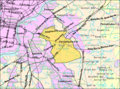 Census Bureau map of Cherry Hill, New Jersey.png 575 × 425; 78 KB
-
 Cherry Hill High School West front, Nov. 2025.jpg 3,523 × 2,730; 3.34 MB
-
 Cherry Hill NJ from airplane approaching PHL.jpeg 4,032 × 3,024; 2.62 MB
-
 Cherry Hill NJ water tower from Garden State Pavilions.jpeg 4,032 × 3,024; 3.65 MB
-
 Cherry Hill, NJ municipal building, Nov. 2025.jpg 3,679 × 2,851; 4.3 MB
-
 Cherry Hill, NJ municipal building, Sept. 2025.jpg 3,783 × 2,877; 3.84 MB
-
 Cherry Hill, NJ World War II memorial, Nov. 2025.jpg 3,159 × 2,423; 2.69 MB
-
 Cherryhillparksign.JPG 4,000 × 3,000; 1.28 MB
-
 Chwestsign.JPG 1,600 × 1,200; 933 KB
-
 Colestown Gatehouse, Cherry Hill, NJ 08034.jpg 1,024 × 683; 327 KB
-
 Cooper River Lake west of Camden CR 636.jpeg 4,032 × 3,024; 3.46 MB
-
 I-295 NJ TPK and NJ 70 in Cherry Hill NJ from airplane approaching PHL.jpeg 4,032 × 3,024; 4.07 MB
-
 Latincasionmenu.jpg 3,264 × 2,448; 1.61 MB
-
 Leaf on Grass, Cherry Hill, NJ 2004.jpg 425 × 550; 60 KB
-
 Map of Camden County highlighting Cherry Hill Township.png 550 × 681; 7 KB
-
 Mkorshalomfront.JPG 1,600 × 1,200; 904 KB
-
 NJ 70 in Cherry Hill - Aerial (51157930424).jpg 2,400 × 3,600; 5.2 MB
-
 Philadelphia skyline from Camden CR 636 bridge over Cooper River Lake.jpeg 4,032 × 3,024; 2.32 MB
-
 PolitzCherryHill.jpg 608 × 1,080; 82 KB
-
 Ponziosdiner.JPG 1,600 × 1,200; 818 KB
-
 Rohrer Campus, Cherry Hill, NJ, Main Building..JPG 4,608 × 3,456; 3.33 MB
-
 TBSmaindoor.JPG 1,600 × 1,200; 1.39 MB
-
 Tom Atkins Monster-Mania Con Cherry Hill NJ February 2007.jpg 150 × 221; 5 KB
-
 Totem par David Ascalon.jpg 700 × 1,076; 173 KB
-
 Wegmans store in Cherry Hill NJ.jpeg 4,032 × 3,024; 3.06 MB
-
 What a loser.jpg 2,374 × 2,155; 1.03 MB

_in_Cherry_Hill_Township,_Camden_County,_New_Jersey.jpg)


.jpg)


