Category:Canoga Park, Los Angeles
English: Canoga Park — a neighborhood of Los Angeles, in the western San Fernando Valley, California.
- • Founded in 1912 as Owensmouth, and renamed Canoga Park in 1931. In 1987 much of the western district of Canoga Park was renamed West Hills, and a portion of the eastern district was renamed Winnetka.
neighborhood in the San Fernando Valley region of the City of Los Angeles, California, United States  | |||||
| Upload media | |||||
| Instance of | |||||
|---|---|---|---|---|---|
| Location | Los Angeles, Los Angeles County, California, Pacific States Region | ||||
| Inception |
| ||||
| Elevation above sea level |
| ||||
 | |||||
Subcategories
This category has the following 5 subcategories, out of 5 total.
Media in category "Canoga Park, Los Angeles"
The following 31 files are in this category, out of 31 total.
-
 Baist's real estate atlas of surveys of Los Angeles, California, 1921 (31382).jpg 4,535 × 6,206; 2.99 MB
-
 Bell Creek.jpg 3,648 × 2,736; 2.14 MB
-
 Floods - California - Bueena Park through Yoba Linda - NARA - 68157371.jpg 6,843 × 5,347; 15.93 MB
-
 Jerry's soda shoppe.jpg 640 × 480; 112 KB
-
 Origin of the Los Angeles River in Canoga Park.jpg 1,500 × 1,120; 888 KB
-
 Owensmouth School Plaque.jpg 2,992 × 2,992; 8.46 MB
-
President Reagan's Remarks at a Reagan-Bush Rally in Canoga Park, California on November 5, 1984.webm 36 min 37 s, 654 × 480; 265.18 MB
-
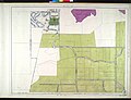
 Rancho El Escorpion Hall Map 1880.png 535 × 600; 579 KB
-
 Sherman Way station.jpg 4,000 × 2,252; 2.73 MB
-
 Ssfl cdc atsdr figure1.gif 701 × 531; 158 KB
-
 California SD-27 (2011).svg 1,450 × 1,680; 55 KB
-
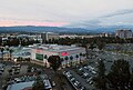
 Westfield Promenade mall sunset.jpg 4,116 × 2,424; 2.48 MB
-
 Westfield Promenade mall vista.jpg 3,647 × 2,464; 1.67 MB
-
 Woodland Hills morning.jpg 2,701 × 2,109; 1.88 MB
-

-

-
-

-

-

-

-

-

-

-

-

-

-
 Automobile road map from Los Angeles to San Fernando Valley, 1917 (AAA-SM-000310).jpg 5,952 × 2,046; 2.25 MB
-
 CA 30 certified.pdf 1,275 × 1,650; 801 KB
-
 California US Congressional District 30 (since 2013).tif 2,016 × 998; 3.05 MB
-

.jpg)


.svg)


,_sheet_16_(383).jpg)
,_sheet_3_(310).jpg)
,_sheet_10_(350).jpg)
,_sheet_11_(355).jpg)
,_sheet_12_(360).jpg)
,_sheet_13_(365).jpg)
,_sheet_19_(400).jpg)
,_sheet_20_(405).jpg)
,_sheet_21_(410).jpg)
,_sheet_22_(415).jpg)
,_sheet_28_(450).jpg)
,_sheet_29_(455).jpg)
,_sheet_30_(460).jpg)
.jpg)