Category:Anafi
Greek island in Aegean Sea  | |||||
| Upload media | |||||
| Instance of | |||||
|---|---|---|---|---|---|
| Location | Anafi Municipality, Thira Regional Unit, South Aegean Region, Decentralized Administration of the Aegean, Greece | ||||
| Located in or next to body of water | |||||
| Population |
| ||||
| Area |
| ||||
| Elevation above sea level |
| ||||
| official website | |||||
 | |||||
Français : Depuis 2010 (réforme Kallikratis), Anafi (Ανάφη) dans les Cyclades est l'un des 325 dèmes (communes, ou municipalités) de Grèce (population : 271 habitants en 2011).
Subcategories
This category has the following 12 subcategories, out of 12 total.
Media in category "Anafi"
The following 16 files are in this category, out of 16 total.
-
 Agioi Apostoloi beach.jpg 2,976 × 3,968; 3.19 MB
-
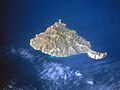 Anafi satellite.jpg 1,846 × 1,385; 3.06 MB
-
 Chora and Kalamos.jpg 3,960 × 2,964; 3.92 MB
-
 Church in Kalamos Mountain.jpg 1,200 × 1,600; 473 KB
-
 Church near Roukounas.jpg 1,200 × 1,600; 642 KB
-
 Church on Kalamos.jpg 1,200 × 1,600; 497 KB
-
 Climbing Kalamos.jpg 1,200 × 1,600; 581 KB
-
 Going to Kalamos.jpg 1,600 × 1,200; 684 KB
-
 Moon view from Kalamos.jpg 1,200 × 1,600; 300 KB
-
 Morning view from Kalamos.jpg 1,200 × 1,600; 390 KB
-
 Road to Roukounas beach.jpg 1,200 × 1,600; 766 KB
-
 Road to Roukounas beach2.jpg 1,200 × 1,600; 631 KB
-
 View from Kalamos.jpg 1,600 × 1,200; 590 KB
-
 View near Kalamos.jpg 1,200 × 1,600; 941 KB
-
 View near Roukounas.jpg 1,200 × 1,600; 1.03 MB
-
 View of Anafi from the church of the Zoodochou Pigis, 226769.jpg 5,872 × 3,907; 9.29 MB


