
Bu fayl Vikianbarda yerləşir. Açıqlama səhifəsindəki məlumatlar aşağıda göstərilib. Vikianbar azad lisenziyalı media anbarıdır. Siz də töhfə verə bilərsiniz. |
Xülasə
| Warning | The original file is very high-resolution. It might not load properly or could cause your browser to freeze when opened at full size. |
|---|
| Description |
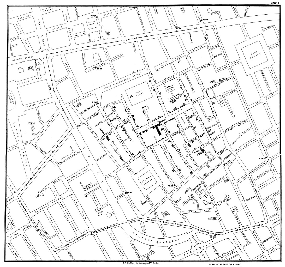
Original map made by John Snow in 1854. Cholera cases are highlighted in black, showing the clusters of cholera cases (indicated by stacked rectangles) in the London epidemic of 1854. The map was created in order to better understand the pattern of cholera spread in the 1854 Broad Street cholera outbreak, which Snow would use as an example of how cholera spread via the fecal-oral route through water systems as opposed to the miasma theory of disease spread. The contaminated pump is located at the intersection of Broad Street and Cambridge Street (now Lexington Street), running into Little Windmill Street. The map marks an important part of the development of epidemiology as a field, and of disease mapping as a whole. |
|||||||||
| Tarix | ||||||||||
| Mənbə |
Map of the book "On the Mode of Communication of Cholera" by John Snow, originally published in 1854 by C.F. Cheffins, Lith, Southhampton Buildings, London, England. The uploaded images is a digitally enhanced version found on the UCLA Department of Epidemiology website. |
|||||||||
| Yaradıcı | ||||||||||
| Geotemporal data | ||||||||||
| Bounding box |
|
|||||||||
| Georeferencing | ||||||||||
| Digər versiyalar | File:Snow-cholera-map.jpg | |||||||||

|
Lisenziya
|
Bu şəkil, təsviri incəsənət əsərinin orijinal ikiölçülü dəqiq fotoqrafiya reproduksiyasıdır. Təsviri incəsənətin bu əsəri öz-özlüyündə aşağıdakı səbəblərdən ictimai varidat sayılır:
"Vikimedia Fondu" tutduğu rəsmi mövqe ondan ibarətdir ki, "ictimai varidat olan təsviri incəsənət əsərlərinin ikiölçülü dəqiq reproduksiyaları da ictimai varidat sayılır". Ətraflı məlumat almaq üçün Commons:When to use the PD-Art tag məqaləsinə baxın.
Beləliklə bu fotoqrafiya reproduksiyası ictimai varidat hesab edilir. Xahiş edirik nəzərə alın ki, yerli qanunvericilikdən asılı olaraq un təkrar istifadəsi qadağandır və ya sizin yurisdiksiyanızda məhdudlaşdırılmış ola bilər. Commons:Reuse of PD-Art photographs məqaləsinə baxın. | ||||
Orijinal yükləmə gündəliyi
(All user names refer to en.wikipedia)
- 2006-12-30 23:15 Rewardiv 3045×2840×8 (1183741 bytes) Original map made by John Snow in 1854, copied from http://matrix.msu.edu/~johnsnow/images/online_companion/chapter_images/fig12-5.jpg Author died in 1858, material is public domain.
Faylın tarixçəsi
Faylın əvvəlki versiyasını görmək üçün gün/tarix bölməsindəki tarixlərə klikləyin.
| Tarix/Vaxt | Miniatür | Ölçülər | İstifadəçi | Şərh | |
|---|---|---|---|---|---|
| hal-hazırkı | 21:19, 16 noyabr 2020 | | 20.124 × 18.877 (18,38 MB) | Artoria2e5 | Reverted to version as of 14:12, 6 May 2020 (UTC) |
| 21:12, 16 noyabr 2020 |  | 1.092 × 1.024 (320 KB) | Artoria2e5 | temporarily reduce size for wikimaps | |
| 14:12, 6 may 2020 |  | 20.124 × 18.877 (18,38 MB) | Sette-quattro | higher resolution version | |
| 13:53, 22 iyun 2007 |  | 3.045 × 2.840 (1,13 MB) | Finavon | {{Information |Description=Original map made by John Snow in 1854, copied from http://matrix.msu.edu/~johnsnow/images/online_companion/chapter_images/fig12-5.jpg Author died in 1858, material is public domain. |Source=Originally from [http://en.wikipedi |
Faylın istifadəsi
Bu faylı istifadə edən səhifə yoxdur (digər layihələrdəki səhifələr göstərilmir).
Faylın qlobal istifadəsi
Bu fayl aşağıdakı vikilərdə istifadə olunur:
- ar.wikipedia.org layihəsində istifadəsi
- bg.wikipedia.org layihəsində istifadəsi
- bh.wikipedia.org layihəsində istifadəsi
- bn.wikipedia.org layihəsində istifadəsi
- ca.wikipedia.org layihəsində istifadəsi
- de.wikipedia.org layihəsində istifadəsi
- de.wikiversity.org layihəsində istifadəsi
- el.wikipedia.org layihəsində istifadəsi
- en.wikipedia.org layihəsində istifadəsi
- Human geography
- Natural experiment
- Water purification
- Public health
- John Snow
- Slow sand filter
- Category talk:Geography
- Portal:Medicine
- Health geography
- Thematic map
- User talk:Mathwhiz 29
- Statistical graphics
- Wikipedia:Featured pictures/Diagrams, drawings, and maps/Maps
- 1846–1860 cholera pandemic
- 1854 Broad Street cholera outbreak
- Talk:1854 Broad Street cholera outbreak
- User:Aetarrell/Practice
- GIS and public health
- Wikipedia:WikiProject Medicine/Recognized content
- Talk:Map
- Dot distribution map
- History of water filters
- Wikipedia:Reference desk/Archives/Humanities/2010 August 24
- History of water supply and sanitation
- User talk:Sarason
- Portal:Geography/Intro/Image
- User:Life in General/Userboxes/HumanGeography
- User talk:Gwooodward
- Portal:Geography/Intro/6
- User:Wouterstomp/test
- Charles Cheffins
- User talk:Khamar
- User talk:OfficialNeon
Bu faylın qlobal istifadəsinə baxın.