_-_20000428.jpg)
_-_20000428.jpg)

Sınaq göstərişi ölçüsü: 800 × 467 piksel. Digər ölçülər: 320 × 187 piksel | 640 × 373 piksel | 1.024 × 597 piksel | 1.280 × 747 piksel | 2.560 × 1.493 piksel | 4.800 × 2.800 piksel.
Faylın orijinalı (4.800 × 2.800 piksel, fayl həcmi: 3,77 MB, MIME növü: image/jpeg)
Bu fayl Vikianbarda yerləşir. Açıqlama səhifəsindəki məlumatlar aşağıda göstərilib. Vikianbar azad lisenziyalı media anbarıdır. Siz də töhfə verə bilərsiniz. |
_-_20000428.jpg)
Xülasə
| İzah |
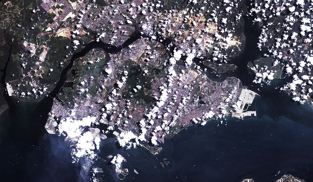
English: A Landsat 7 image of Singapore at 14.25-meter resolution. Based on Global Orthorectified Landsat dataset (ETM+); WRS_PATH 125, WRS_ROW 59. Generated using panchromatic band for intensity, and color from "true-color" combination of 28.5-meter resolution bands 3, 2, and 1 (as R, G, B respectively). Data combined and color curves enhanced in the Gimp. |
| Tarix | Data acquisition: 28 aprel 2000. Orthorectified version produced: 4 dekabr 2002. This image created: 6 fevral 2007. |
| Mənbə | Data from the USGS GloVis server. Landsat Orthorectified data generated through NASA's Commercial Remote Sensing Program. |
| Müəllif | Data: National Aeronautics and Space Administration (NASA). Image: Dave Pape. |
| İcazə (Faylın təkrar istifadəsi) |
Original data PD-NASA; any copyright that exists from my creation of this image is dedicated to the public domain (PD-SELF). |
| Camera location | | View this and other nearby images on: OpenStreetMap |
|---|
_-_20000428.jpg¶ms=001.299708_N_0103.850327_E_globe:Earth_type:camera_type:landmark_&language=az)
Lisenziya
| This file is in the public domain in the United States because it was solely created by NASA. NASA copyright policy states that "NASA material is not protected by copyright unless noted". (See Template:PD-USGov, NASA copyright policy page or JPL Image Use Policy.) | ||
 |
Warnings:
|
This work is based on a work in the public domain. It has been digitally enhanced and/or modified. This derivative work has been (or is hereby) released into the public domain by its author, Davepape. This applies worldwide.
In some countries this may not be legally possible; if so: |
Faylın tarixçəsi
Faylın əvvəlki versiyasını görmək üçün gün/tarix bölməsindəki tarixlərə klikləyin.
| Tarix/Vaxt | Miniatür | Ölçülər | İstifadəçi | Şərh | |
|---|---|---|---|---|---|
| hal-hazırkı | 18:29, 6 fevral 2007 | | 4.800 × 2.800 (3,77 MB) | Davepape | {{af|style="margin-left:0.5em;" width="300px"> }} {{am|'''ሲንጋፖር''' am:ከተማ-አገር ነው።}} {{an|A '''Republica de Singapur''' (En anglés ''Republic of Singapore''; en chin 新加坡共 |
Faylın istifadəsi
Bu faylı istifadə edən səhifə yoxdur (digər layihələrdəki səhifələr göstərilmir).
Faylın qlobal istifadəsi
Bu fayl aşağıdakı vikilərdə istifadə olunur:
- it.wikibooks.org layihəsində istifadəsi
- trv.wikipedia.org layihəsində istifadəsi
- zh.wikipedia.org layihəsində istifadəsi
_-_20000428.jpg)