
Sınaq göstərişi ölçüsü: 800 × 586 piksel. Digər ölçülər: 320 × 234 piksel | 640 × 469 piksel | 1.024 × 750 piksel | 1.280 × 938 piksel | 2.048 × 1.500 piksel.
Faylın orijinalı (2.048 × 1.500 piksel, fayl həcmi: 268 KB, MIME növü: image/jpeg)
Bu fayl Vikianbarda yerləşir. Açıqlama səhifəsindəki məlumatlar aşağıda göstərilib. Vikianbar azad lisenziyalı media anbarıdır. Siz də töhfə verə bilərsiniz. |

|
File:Iron ore Pilbara 2.svg is a vector version of this file. It should be used in place of this JPG file when not inferior.
File:Iron ore Pilbara.jpg → File:Iron ore Pilbara 2.svg
For more information, see Help:SVG. |
 |
Xülasə
| İzah |
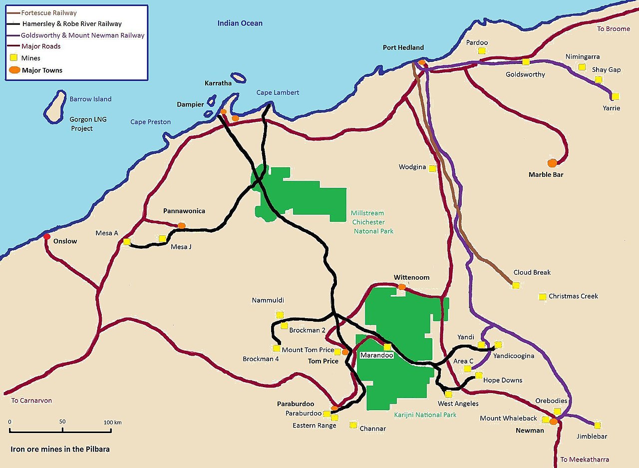
English: Map of the iron ore mines & railways in the Pilbara region of Western Australia. |
| Tarix | |
| Mənbə | Öz işi |
| Müəllif | Calistemon |
Lisenziya
I, the copyright holder of this work, hereby publish it under the following licenses:
Bu fayl Creative Commons Attribution-Share Alike 3.0 Unported lisenziyası altında yayımlanır.
- Siz heç bir məhdudiyyət olmadan:
- paylaşa bilərsiniz – əsəri köçürə, paylaya və ötürə bilərsiniz
- remiks edə bilərsiniz – əsəri adaptasiya edə bilərsiniz
- Aşağıdakı şərtlərə əməl etməklə:
- istinad vermək – Müvafiq istinad verməli, lisenziyaya keçid əlavə etməli və dəyişikliklər edilib-edilmədiyini bildirməlisiniz . Siz bunu istənilən şəkildə edə bilərsiniz, lakin lisenziya verənin sizə şəxsən icazə verdiyini göstərən formada yox.
- bənzər paylaşma – Əsəri remix edirsinizsə, dəyişdirirsinizsə və ya üzərində iş aparırsınızsa, öz töhfələrinizi orijinalda olduğu kimi eyni və ya uyğun lisenziya altında yayımlamalısınız.

|
Bu sənədi GNU Azad Sənədləşdirmə Lisenziyası, Versiya 1.2 və ya Azad Proqram Fondu tərəfindən nəşr olunan hər hansı sonrakı versiya şərtlərinə əsasən dəyişməz bölmələr, ön qapaq mətnləri və arxa qapaq mətnləri olmadan köçürmək, yayımlamaq və / və ya dəyişdirmək üçün icazə verilir; Lisenziyanın bir nüsxəsi GNU Azad Sənədləşdirmə Lisenziyası adlı hissəyə daxil edilmişdir. |
İstədiyiniz lisenziyanı seçə bilərsiniz.
Faylın tarixçəsi
Faylın əvvəlki versiyasını görmək üçün gün/tarix bölməsindəki tarixlərə klikləyin.
| Tarix/Vaxt | Miniatür | Ölçülər | İstifadəçi | Şərh | |
|---|---|---|---|---|---|
| hal-hazırkı | 07:59, 7 dekabr 2010 | | 2.048 × 1.500 (268 KB) | Calistemon | Colored in ocean. |
| 07:32, 7 dekabr 2010 |  | 2.048 × 1.500 (266 KB) | Calistemon | Town names in bold and black. | |
| 07:14, 7 dekabr 2010 |  | 2.048 × 1.500 (264 KB) | Calistemon | Coloring in of land mass, as done by User:Gnangarra. | |
| 02:03, 7 dekabr 2010 |  | 2.048 × 1.500 (263 KB) | Calistemon | Fixed spelling mistake. | |
| 01:54, 7 dekabr 2010 |  | 2.048 × 1.500 (266 KB) | Calistemon | Add barrow Island, Gorgon, the Sino project and Western Turner. | |
| 01:34, 7 dekabr 2010 |  | 2.048 × 1.500 (257 KB) | Calistemon | Increased size of writing. | |
| 02:18, 5 dekabr 2010 |  | 2.048 × 1.500 (238 KB) | Calistemon | Clean up map, add some more locations. | |
| 15:05, 4 dekabr 2010 |  | 2.048 × 1.500 (235 KB) | Calistemon | Added missing Mount Tom Price mine, removed section of road thats not a major road. | |
| 14:40, 4 dekabr 2010 |  | 2.048 × 1.500 (234 KB) | Calistemon | {{Information |Description={{en|1=Map of the iron ore mines in the Pilbara region of Western Australia.}} |Source={{own}} |Author=Calistemon |Date=2010-12-04 |Permission= |other_versions= }} |
Faylın istifadəsi
Bu faylı istifadə edən səhifə yoxdur (digər layihələrdəki səhifələr göstərilmir).
Faylın qlobal istifadəsi
Bu fayl aşağıdakı vikilərdə istifadə olunur:
- en.wikipedia.org layihəsində istifadəsi