Butun axtardiqlarinizi tapmaq ucun buraya: DAXIL OLUN
  Mp4 Mp3 Axtar Yukle
  Video Axtar Yukle
  Shekil Axtar Yukle
  Informasiya Melumat Axtar
  Hazir Inshalar Toplusu
  AZERI CHAT + Tanishliq
  1-11 Sinif Derslikler Yukle
  Saglamliq Tibbi Melumat
  Whatsapp Plus Yukle(Yeni)

  • Ana səhifə
  • Təsadüfi
  • Yaxınlıqdakılar
  • Daxil ol
  • Nizamlamalar
İndi ianə et Əgər Vikipediya sizin üçün faydalıdırsa, bu gün ianə edin.

Fayl:Mars Géolocalisation.jpg

  • Fayl
  • Müzakirə
  • Vikianbar üzərindən baxış
  • Lokal izah əlavə et
  • Fayl
  • Faylın tarixçəsi
  • Faylın istifadəsi
  • Faylın qlobal istifadəsi
  • Metaməlumatlar
Fayl:Mars Géolocalisation.jpg
Sınaq göstərişi ölçüsü: 800 × 400 piksel. Digər ölçülər: 320 × 160 piksel | 640 × 320 piksel | 1.024 × 512 piksel | 1.280 × 640 piksel | 2.048 × 1.024 piksel.
Faylın orijinalı (2.048 × 1.024 piksel, fayl həcmi: 1,55 MB, MIME növü: image/jpeg)
Bu fayl Vikianbarda yerləşir. Açıqlama səhifəsindəki məlumatlar aşağıda göstərilib.
Vikianbar azad lisenziyalı media anbarıdır. Siz də töhfə verə bilərsiniz.

Xülasə

İzahMars Géolocalisation.jpg
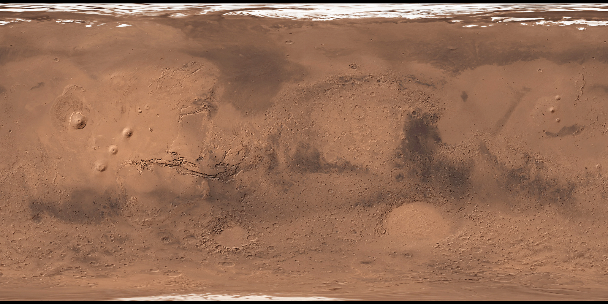
Français : Carte de Mars reconstituée à partir des mesures de Mars Global Surveyor (MOLA) et des observations de Viking.
Tarix 2 avqust 2008 (upload date)
Mənbə MOLA Shaded Relief & Viking.
Müəllif NASA, USGS et Who killed Bambi ? pour les retouches.
Digər versiyalar
Image extraction process This image has an extracted file: Mars Géolocalisation 2.JPG.
lang=az

Lisenziya

Public domainPublic domainfalsefalse
Public domain This file is in the public domain in the United States because it was solely created by NASA. NASA copyright policy states that "NASA material is not protected by copyright unless noted". (See Template:PD-USGov, NASA copyright policy page or JPL Image Use Policy.)
Warnings:
  • Use of NASA logos, insignia and emblems is restricted per U.S. law 14 CFR 1221.
  • The NASA website hosts a large number of images from the Soviet/Russian space agency, and other non-American space agencies. These are not necessarily in the public domain.
  • Materials based on Hubble Space Telescope data may be copyrighted if they are not explicitly produced by the STScI.[1] See also {{PD-Hubble}} and {{Cc-Hubble}}.
  • The SOHO (ESA & NASA) joint project implies that all materials created by its probe are copyrighted and require permission for commercial non-educational use. [2]
  • Images featured on the Astronomy Picture of the Day (APOD) web site may be copyrighted. [3]
  • The National Space Science Data Center (NSSDC) site has been known to host copyrighted content. Its photo gallery FAQ states that all of the images in the photo gallery are in the public domain "Unless otherwise noted."
Public domainPublic domainfalsefalse
Public domain
This image is in the public domain in the United States because it only contains materials that originally came from the United States Geological Survey, an agency of the United States Department of the Interior. For more information, see the official USGS copyright policy.

Bahasa Indonesia ∙ català ∙ čeština ∙ Deutsch ∙ eesti ∙ English ∙ español ∙ français ∙ galego ∙ italiano ∙ Nederlands ∙ português ∙ polski ∙ sicilianu ∙ suomi ∙ Tiếng Việt ∙ Türkçe ∙ български ∙ македонски ∙ русский ∙ മലയാളം ∙ 한국어 ∙ 日本語 ∙ 中文 ∙ 中文(简体) ∙ 中文(繁體) ∙ العربية ∙ فارسی ∙ +/−

Annotations
InfoField
This image is annotated: View the annotations at Commons
686
550
20
20
2048
1024

Ophir Catenae

Başlıqlar

Bu faylın nəyi təmsil etdiyinə dair bir sətirlik izahat əlavə et

Bu faylda təsvir olunan elementlər

təsvir edir

copyright status ingilis

ictimai mülkiyyət

yurisdiksiyasındadır: Amerika Birləşmiş Ştatları
təyinetmə üsulu: work of the federal government of the United States ingilis

yaranma tarixi

2 avqust 2008

data size ingilis

1.625.305 Bayt

hündürlüyü/boyu

1.024 piksel

eni

2.048 piksel

media type ingilis

image/jpeg

checksum ingilis

dc05c4978189f5491e8f4d1842406e0a8c337464

təyinetmə üsulu: SHA-1

Faylın tarixçəsi

Faylın əvvəlki versiyasını görmək üçün gün/tarix bölməsindəki tarixlərə klikləyin.

Tarix/VaxtMiniatürÖlçülərİstifadəçiŞərh
hal-hazırkı11:34, 2 avqust 200811:34, 2 avqust 2008 tarixindəki versiyanın miniatür görüntüsü2.048 × 1.024 (1,55 MB)Who killed Bambi ?{{Information |Description= |Source= |Date= |Author= |Permission= |other_versions= }}
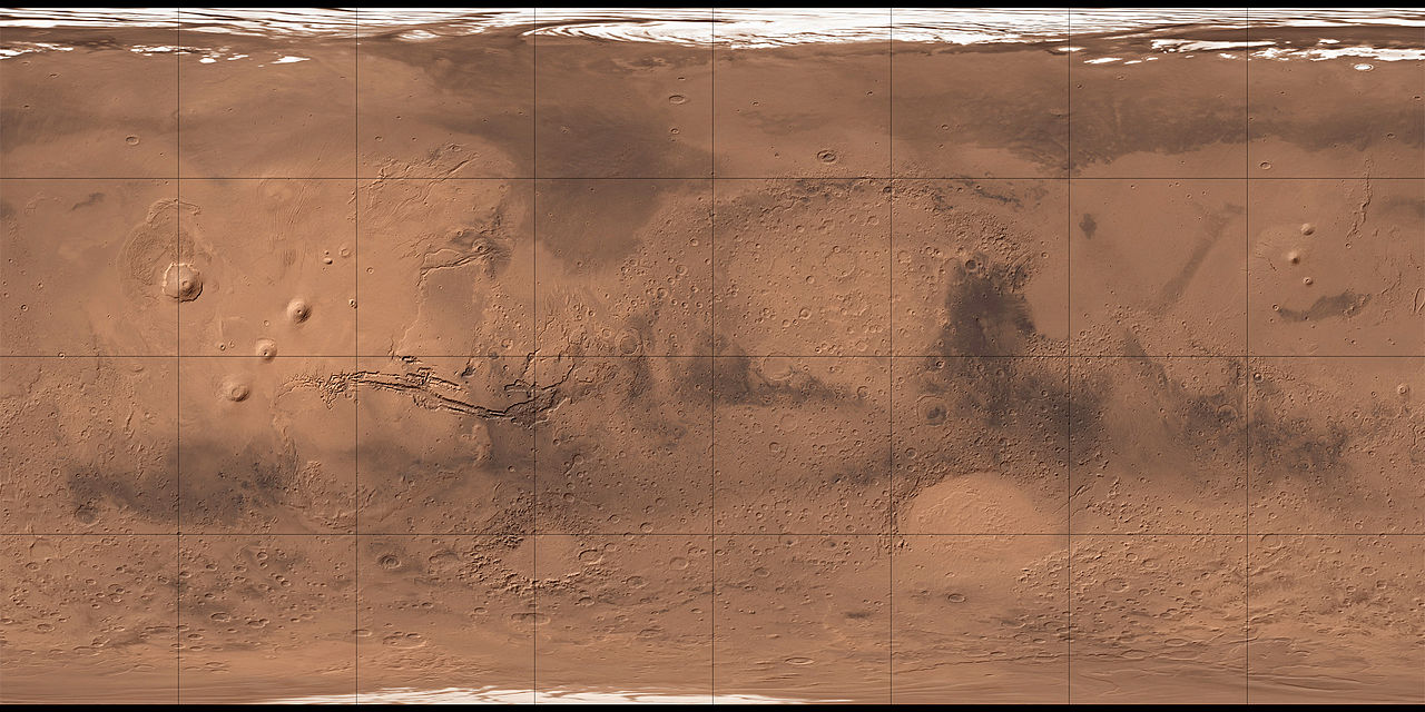
13:07, 27 iyul 200813:07, 27 iyul 2008 tarixindəki versiyanın miniatür görüntüsü2.048 × 1.024 (1,96 MB)Who killed Bambi ?{{Information |Description={{fr|1=Carte de Mars reconstituée à partir des observations de Viking}} |Source=ftp://ftpflag.wr.usgs.gov/dist/pigpen/mars/usgs/mdim1_color/ |Author=USGS |Date=03/04/2004 |Permission= |other_versions= }} {{ImageUpload|full}}

Faylın istifadəsi

Aşağıdakı 5 səhifə bu faylı istifadə edir:

  • Erebus (krater)
  • Olimp (Mars)
  • Tovuz quşu dağı
  • İbrahimov krateri
  • Şablon:Yer xəritəsi Mars

Faylın qlobal istifadəsi

Bu fayl aşağıdakı vikilərdə istifadə olunur:

  • ar.wikipedia.org layihəsində istifadəsi
    • أرض عشتار
    • ندبة هيبيس
    • وادي النيل (المريخ)
    • فاستيتاس بورياليس
    • أريس فاليس
    • جبل أوليمبوس مونز
    • قمة اسكريوس
    • جبل ماكسويل
    • فوهة غيل
    • فكتوريا (فوهة)
    • جبل الريح (المريخ)
    • جبل غولا
    • جبل أبيونا
    • جبل أنالا
    • جبل ساباس
    • جبل ثيا
    • جبل ماعت
    • جبل أوشاس
    • وجه على المريخ
    • أرض العرب (المريخ)
    • قالب:خريطة مواقع المريخ
    • منطقة ألفا
    • منطقة بيتا
    • بافونيس مونس
    • وادي مارينر
    • هضبة سوريا (المريخ)
    • الحوض القطبي الشمالي
    • هيكاتيس ثولوس (المريخ)
    • يوتوبيا بلانيشيا
  • ba.wikipedia.org layihəsində istifadəsi
    • Ҡалып:ПозКарта Марс
  • be.wikipedia.org layihəsində istifadəsi
    • Кідонія (Марс)
    • Шаблон:На карце/Марс
  • bg.wikipedia.org layihəsində istifadəsi
    • Галилей (Марс)
    • Гал (марсиански кратер)
    • Гилберт (кратер на Марс)
    • Миямото (кратер)
    • Восток (кратер)
    • Хюйгенс (кратер)
    • Корольов (кратер на Марс)
    • Хершел (кратер на Марс)
    • Нютон (кратер на Марс)
    • Гейл (кратер)
    • Шаблон:ПК Марс
  • ca.wikipedia.org layihəsində istifadəsi
    • Olympus Mons
    • Nix Olympica
    • Vastitas Borealis
    • Valles Marineris
    • Noctis Labyrinthus
    • Utopia Planitia
    • Cerberus Fossae

Bu faylın qlobal istifadəsinə baxın.

Metaməlumatlar

Bu faylda fotoaparat və ya skanerlə əlavə olunmuş məlumatlar var. Əgər fayl sonradan olunubsa, bəzi parametrlər bu şəkildə göstərilənlərdən fərqli ola bilər.

_error0
Mənbə — "https://az.wikipedia.org/wiki/Fayl:Mars_Géolocalisation.jpg"
Informasiya Melumat Axtar