
Bu SVG-faylın PNG formatındakı bu görünüşünün ölçüsü: 800 × 522 piksel. Digər ölçülər: 320 × 209 piksel | 640 × 418 piksel | 1.024 × 669 piksel | 1.280 × 836 piksel | 2.560 × 1.671 piksel | 1.625 × 1.061 piksel.
Faylın orijinalı (SVG faylı, nominal olaraq 1.625 × 1.061 piksel, faylın ölçüsü: 945 KB)
Bu fayl Vikianbarda yerləşir. Açıqlama səhifəsindəki məlumatlar aşağıda göstərilib. Vikianbar azad lisenziyalı media anbarıdır. Siz də töhfə verə bilərsiniz. |
Xülasə
| This file may be updated to reflect new information. If you wish to use a specific version of the file without it being overwritten, please upload the required version as a separate file. |
| İzah |
Català: Mapa detallat de l'insurgència al Iemen. Controlat pel Govern liderat per Alimi
Controlat pel Comitè Revolucionari
Controlat pel Consell de Transicó del Sud.
Controlat per Ansar al-Sharia/AQPA forces
Controlat per l'Estado Islàmic(IS)
Controlat per forces lleials a Ali Abdullah Saleh.
Controlat per forces locals no alineades com l' Aliança Tribal Hadhramaut. Deutsch: Detaillierte Karte des Bürgerkriegs im Jemen. Kontrolliert durch Anhänger von Abed Rabbo Mansur Hadi. (Rot)
Kontrolliert durch die Huthi. (Hellgrün)
Kontrolliert durch den Südübergangsrat. (Ocker)
Kontrolliert durch al-Qaida auf der Arabischen Halbinsel. (Weiß)
Kontrolliert durch den Islamischen Staat. (Grau)
Kontrolliert durch Anhänger von Ali Abdullah Salih. (Hellblau)
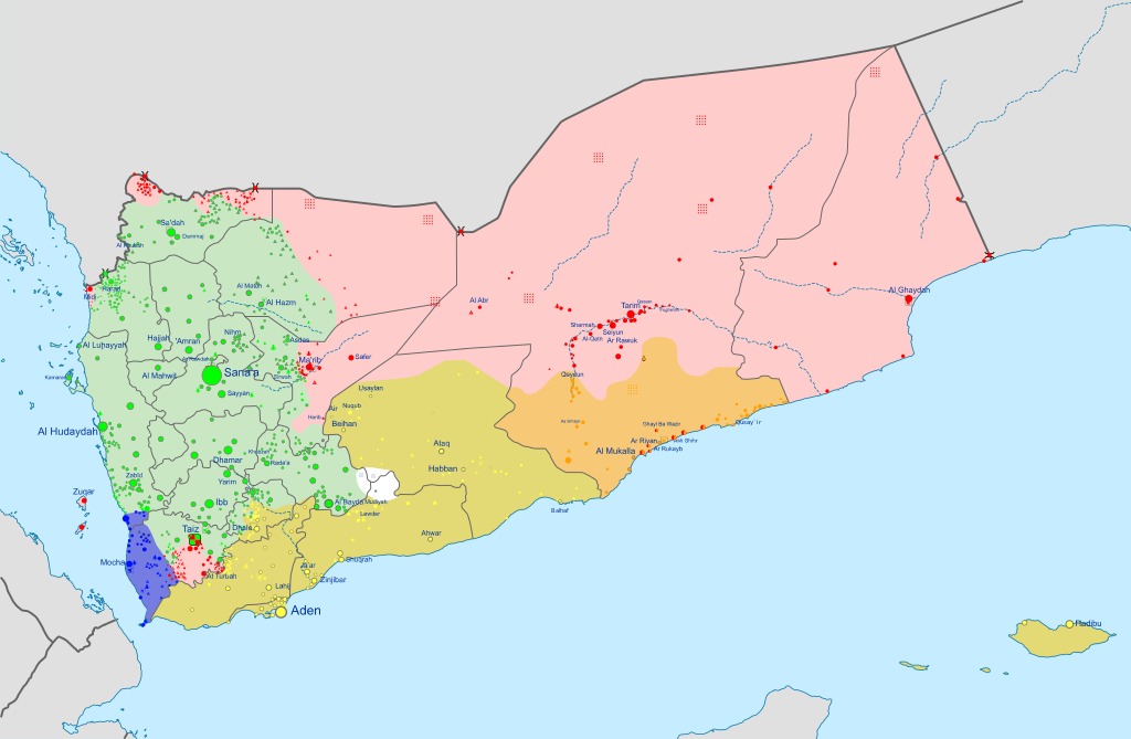
Kontrolliert durch die Elitetruppen der Hadrami. (Orange) English: Insurgency in Yemen detailed Map according to published reports. This map's information is sometimes based on w:Module:Yemeni Civil War detailed map. For sources, see that page's history and talk page. For a visual representation of the data, see that module's documentation page. Controlled by Presidential Leadership Council-led government.
Controlled by the w:Houthi's w:Supreme Political Council.
Controlled by Southern Transitional Council.
Controlled by Ansar al-Sharia/AQAP forces.
Controlled by Hadrami Elite Forces.
Controlled by Tareq Saleh's National Resistance Forces. Español: Mapa detallado de la insurgencia en Yemen. Controlado por el Gobierno liderado por Alimi
Controlado por el Comité Revolucionario
Controlado por el Southern Transitional Council.
Controlado por Ansar al-Sharia/AQPA forces
Controlado por el Estado Islámico (EI) Français : Conflit au Yémen, d'après une carte de Mark Monmonier. Territoire contrôlé par les loyalistes du gouvernement Alimi.
Territoire contrôlé par les Houthis.
Territoire contrôlé par le Conseil de transition du Sud.
Territoire contrôlé par les Forces d'élite hadhramies.
Territoire contrôlé par la Résistance nationale
Territoire contrôlé par les djihadistes d'Ansar al-Sharia/AQAP. Italiano: Mappa dettagliata della situazione attuale in Yemen. Controllato dalle truppe di w:it:Rashad al-Alimi
Controllato dal w:it:Comitato Rivoluzionario
Controlled by Southern Transitional Council.
Controllato da w:it:Ansar al-Sharia/AQPA forces
Controllato dallo w:it:Stato Islamico
Controlled by local, non-aligned forces like the Hadhramaut Tribal Alliance. Nederlands: Gedetailleerde kaart van de Jeministische Burgeroorlog (2015). Gecontroleerd door Hadi-led government.
Gecontroleerd door Revolutionary Committee.
Gecontroleerd door Southern Transitional Council.
Gecontroleerd door Ansar al-Sharia/AQAP forces.
Gecontroleerd door de Islamic State (IS).
Gecontroleerd door lokale, niet aangesloten groep zoals Hadhramaut Tribal Alliance. Português: Insurgência no {{w:pt|Iémen}} mapa detalhado de acordo com relatórios publicados. Controlado pelo Governo liderado pelo Conselho de Liderança Presidencial.
Controlado pelo :Comitê Revolucionário.
Controlado pelo Conselho de Transição do Sul.
Controlado pelo Ansar al-Sharia/AQAP.
Controlado pelo Estado Islâmico (IS).
Controlado por forças locais e não-alinhadas, como a Aliança Tribal de Hadramaute. Ελληνικά: Η κατάσταση στον Υεμενικό Εμφύλιο Πόλεμο, όπως έχει διαμορφωθεί σύμφωνα με δημοσιεύματα. Controlled by Alimi-led government.
Περιοχή ελεγχόμενη από την Επαναστατική Επιτροπή.
Περιοχή ελεγχόμενη από την κυβέρνηση Χάντι και το Νότιο Κίνημα.
Περιοχή ελεγχόμενη από δυνάμεις των οργανώσεων Ανσάρ αλ-Σαρία/Αλ Κάιντα.
Περιοχή ελεγχόμενη από το Ισλαμικό Κράτος.
Controlled by forces loyal to Ali Abdullah Saleh.
Controlled by local, non-aligned forces like the Hadhramaut Tribal Alliance. Русский: Подробная карта мятежа в Йемене. Под контролем Правительства Хади в изгнании.
Под контролем Ансар Аллах
Под контролем Южного Переходного Совета.
Под контролем Аль-Каиды на Аравийском полуострове.
Под контролем Исламского государства Ирака и Леванта (ИГИЛ).
Под контролем местных сил.
Под контролем племён Хадрамауты. Українська: Детальна мапа повстання в Ємені згідно з опублікованими доповідями. Інформація на цій карті частково взята з w:Module:Yemeni Civil War detailed map. Щоб переглянути джерела sources, перегляньте історію цієї сторінки і сторінку обговорення. Щоб побачити візуальну репрезентацію даних, see that module's documentation page. Контролюється Hadi-led government.
Контролюється by Revolutionary Committee.
Контролюється Південною Перехідною Радою.
Контролюється Ansar al-Sharia/AQAP forces.
Контролюється ІДІЛ (IS).
Контролюється місцевими, non-aligned формуваннями, наприклад Hadhramaut Tribal Alliance. 한국어: 예멘 반란 상세지도. 예멘 정부 통치 하의 지역.
후티 반군과 살레정부군 통치 하의 지역.
남예멘 분리주의자(남부과도위원회) 통치 하의 지역.
알카에다 통치 하의 지역.
이슬람 국가(IS) 통치 하의 지역.
Controlled by local, non-aligned forces like the Hadhramaut Tribal Alliance. 日本語: イエメン内戦の勢力図。 ハーディー大統領政権(イエメン政府)支配下の地域
最高政治評議会(フーシ派)支配下の地域
南部暫定評議会支配下の地域
アラビア半島のアルカーイダ傘下のアンサル・アルシャリア支配下の地域
IS支配下の地域
ハドラマウト部族同盟のような地域の非同盟勢力支配下の地域 中文: 也门局势地图。 也门总统阿卜杜拉布·曼苏尔·哈迪支持者控制。
胡塞武装和薩利赫的支持者控制。
南方過渡委員會控制。
伊斯兰国控制区。
哈德拉毛部落联盟(Hadhramaut Tribal Alliance)等当地势力控制。 اردو : یمنی خاناجنگی کی صورتحال. صابق صدر، منصور ہادی کے حامیوں کے قبضے میں.
حوثی باغیوں اور علی عبدالله صالح کے حامیوں کے قبضے میں.
Controlled by Southern Transitional Council.
القاعدہ کے قبضے میں.
Controlled by the Islamic State (IS).
Controlled by local, non-aligned forces like the Hadhramaut Tribal Alliance. العربية : النزاع في اليمنː تسيطر عليها حكومة الرئيس عبد ربه منصور هادي.
تحت سيطرة الحوثيون.
تحت سيطرة المجلس الانتقالي الجنوبي.
تحت سيطرة تنظيم القاعدة في جزيرة العرب القاعدة و أنصار الشريعة.
تحت سيطرة داعش أو موالون لها
تحت سيطرة المقاومة الوطنية اليمنية.
تحت سيطرة قوات النخبة الحضرمية وقوات محلية مثل تحالف حضرموت القبلي. فارسی : نقشهٔ جزئیات درگیریهای جنگ داخلی یمن. در دست نیروهای هوادار منصور هادی.
در دست انصارالله.
در دست مجلس انتقالی جنوب.
در دست القاعده یا انصارالشریعه (وفادار به داعش).
Controlled by the Islamic State (IS).
Controlled by local, non-aligned forces like the Hadhramaut Tribal Alliance. |
||||
| Tarix | |||||
| Mənbə |
Citing Sana'a Center for Strategic Studies via Al Jazeera, 9 dekabr 2025. Houthi territory per Critical Threats. STC-PLC frontline per Foreign Affairs. Derivative of: Yemen location map.svg by NordNordWest. Borysk5, |
||||
| Müəllif | Ali Zifan | ||||
| Digər versiyalar |
 |
||||
| SVG genesis |


.svg)


.svg)

.svg)
.svg)


_Territory_Change_2014-2016.gif)

_(within_Northern_Syria).svg)


.png)
.svg)


_map.png)
.svg)
.svg)


.svg)


Lisenziya
Mən, bu işin müəllif hüquqları sahibi, onu aşağıdakı lisenziyaya əsasən dərc edirəm:
Bu fayl Creative Commons Attribution-Share Alike 4.0 Beynəlxalq lisenziyası altında yayımlanır.
- Siz heç bir məhdudiyyət olmadan:
- paylaşa bilərsiniz – əsəri köçürə, paylaya və ötürə bilərsiniz
- remiks edə bilərsiniz – əsəri adaptasiya edə bilərsiniz
- Aşağıdakı şərtlərə əməl etməklə:
- istinad vermək – Müvafiq istinad verməli, lisenziyaya keçid əlavə etməli və dəyişikliklər edilib-edilmədiyini bildirməlisiniz . Siz bunu istənilən şəkildə edə bilərsiniz, lakin lisenziya verənin sizə şəxsən icazə verdiyini göstərən formada yox.
- bənzər paylaşma – Əsəri remix edirsinizsə, dəyişdirirsinizsə və ya üzərində iş aparırsınızsa, öz töhfələrinizi orijinalda olduğu kimi eyni və ya uyğun lisenziya altında yayımlamalısınız.
Faylın tarixçəsi
Faylın əvvəlki versiyasını görmək üçün gün/tarix bölməsindəki tarixlərə klikləyin.
| Tarix/Vaxt | Miniatür | Ölçülər | İstifadəçi | Şərh | |
|---|---|---|---|---|---|
| hal-hazırkı | 20:37, 21 dekabr 2025 | | 1.625 × 1.061 (945 KB) | Ecrusized | Size fix. |
| 19:49, 21 dekabr 2025 |  | 1.625 × 1.061 (1,28 MB) | Ecrusized | Updated Houthi territory per "criticalthreats" and STC-PLC frontline per Foreign Affairs. https://www.criticalthreats.org/analysis/iran-update-december-19-2025 & https://www.foreignaffairs.com/yemen/middle-easts-most-overlooked-threat | |
| 09:17, 13 dekabr 2025 |  | 1.625 × 1.061 (935 KB) | Ecrusized | Reduced the size of the roads by about 20% | |
| 21:09, 12 dekabr 2025 |  | 1.625 × 1.061 (935 KB) | Ecrusized | Revert to Al Jazeera map from 9 December before the edit warring took place. https://www.aljazeera.com/news/2025/12/9/who-are-the-groups-controlling-yemen | |
| 20:31, 12 dekabr 2025 |  | 1.625 × 1.061 (762 KB) | LindbergCamilla | Reverted to version as of 20:21, 12 December 2025 (UTC): Aligns better with maps published by https://english.iswnews.com/category/map/yemen-map/, a more detailed and specialized source when compared to Al Jazeera | |
| 20:27, 12 dekabr 2025 |  | 1.625 × 1.061 (935 KB) | PlebeianTribune | Reverted to version as of 20:01, 12 December 2025 (UTC) previous was unsourced revert. | |
| 20:21, 12 dekabr 2025 |  | 1.625 × 1.061 (762 KB) | LindbergCamilla | Reverted to version as of 19:33, 12 December 2025 (UTC): Reverted without context | |
| 20:01, 12 dekabr 2025 |  | 1.625 × 1.061 (935 KB) | مهدی سالمی | Reverted to version as of 17:54, 12 December 2025 (UTC) | |
| 19:33, 12 dekabr 2025 |  | 1.625 × 1.061 (762 KB) | LindbergCamilla | Reverted to version as of 17:24, 12 December 2025 (UTC): Aligned with more accurate source; specifically focused on the region. Consider adding roads and highways to this one. | |
| 17:54, 12 dekabr 2025 |  | 1.625 × 1.061 (935 KB) | Ecrusized | Added a layer of roads and highways, via OpenStreetMap. |
Faylın istifadəsi
Aşağıdakı səhifə bu faylı istifadə edir:
Faylın qlobal istifadəsi
Bu fayl aşağıdakı vikilərdə istifadə olunur:
- af.wikipedia.org layihəsində istifadəsi
- ar.wikipedia.org layihəsində istifadəsi
- دولة دمية
- التدخل العسكري في اليمن
- الحرب الأهلية اليمنية (2014–الآن)
- قالب:صندوق معلومات الحرب الأهلية اليمنية
- قالب:صندوق معلومات التدخل العسكري في اليمن
- الخط الزمني للتدخل العسكري في اليمن
- معركة نهم
- قائمة الجماعات المسلحة في الحرب الأهلية اليمنية
- معاملة المثليين في اليمن
- ضربات الطائرات المسيرة في اليمن
- مستخدم:أبو العلاء العلوي/ملعب
- أزمة البحر الأحمر
- هجوم حضرموت 2025
- azb.wikipedia.org layihəsində istifadəsi
- ba.wikipedia.org layihəsində istifadəsi
- be.wikipedia.org layihəsində istifadəsi
- bg.wikipedia.org layihəsində istifadəsi
- bn.wikipedia.org layihəsində istifadəsi
- bn.wikiquote.org layihəsində istifadəsi
- br.wikipedia.org layihəsində istifadəsi
- bs.wikipedia.org layihəsində istifadəsi
- ca.wikipedia.org layihəsində istifadəsi
- ckb.wikipedia.org layihəsində istifadəsi
- cs.wikipedia.org layihəsində istifadəsi
- da.wikipedia.org layihəsində istifadəsi
- de.wikipedia.org layihəsində istifadəsi
- diq.wikipedia.org layihəsində istifadəsi
- el.wikipedia.org layihəsində istifadəsi
- en.wikipedia.org layihəsində istifadəsi
Bu faylın qlobal istifadəsinə baxın.