
Sınaq göstərişi ölçüsü: 604 × 599 piksel. Digər ölçülər: 242 × 240 piksel | 639 × 634 piksel.
Faylın orijinalı (639 × 634 piksel, fayl həcmi: 85 KB, MIME növü: image/jpeg)
Bu fayl Vikianbarda yerləşir. Açıqlama səhifəsindəki məlumatlar aşağıda göstərilib. Vikianbar azad lisenziyalı media anbarıdır. Siz də töhfə verə bilərsiniz. |
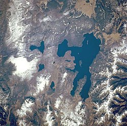
| İzah | Yellowstone National Park, the largest national park in the United States, and Yellowstone Lake, the largest high-mountain lake in North America [139 square miles (360 square kilometers)], are featured in this west-southwest-looking, low-oblique photograph. The park lies atop a massive, dish-shaped, volcanic caldera approximately 30 miles (48 kilometers) by 45 miles (72 kilometers) in size. The caldera was partially filled by lava that flowed from the cracks and opening floor after the massive eruption and collapse of the volcano approximately 600 000 years ago—an eruption 1000 times the force of the 1980 eruption of Mount Saint Helens Volcano in Washington. With approximately 10 000 geysers and hot springs, Yellowstone sits on one of the hottest "hot spots" on Earth. Between 1923 and 1985, the caldera rose almost 4 feet (1 meter) in height. Since 1985, the caldera has sunk approximately 6 inches (15 centimeters). Visible are portions of the volcanic Absaroka Range to the east and three smaller lakes near Yellowstone Lake—Shoshone, to the southwest; Lewis, southeast of Shoshone; and Heart Lake, the smallest and most southeastern. |
| Tarix | |
| Mənbə | http://earth.jsc.nasa.gov/sseop/efs/photoinfo.pl?PHOTO=STS068-247-61 |
| Müəllif | NASA |
This image or video was catalogued by one of the centers of the United States National Aeronautics and Space Administration (NASA) under Photo ID: STS068-247-61. This tag does not indicate the copyright status of the attached work. A normal copyright tag is still required. See Commons:Licensing. Other languages:
|
| This file is in the public domain in the United States because it was solely created by NASA. NASA copyright policy states that "NASA material is not protected by copyright unless noted". (See Template:PD-USGov, NASA copyright policy page or JPL Image Use Policy.) | ||
Warnings:
|
Faylın tarixçəsi
Faylın əvvəlki versiyasını görmək üçün gün/tarix bölməsindəki tarixlərə klikləyin.
| Tarix/Vaxt | Miniatür | Ölçülər | İstifadəçi | Şərh | |
|---|---|---|---|---|---|
| hal-hazırkı | 10:19, 1 sentyabr 2005 | | 639 × 634 (85 KB) | Roger469 | Yellowstone National Park and Yellowstone Lake, Wyoming, October 1994 |
Faylın istifadəsi
Aşağıdakı səhifə bu faylı istifadə edir:
Faylın qlobal istifadəsi
Bu fayl aşağıdakı vikilərdə istifadə olunur:
- ar.wikipedia.org layihəsində istifadəsi
- arz.wikipedia.org layihəsində istifadəsi
- bn.wikivoyage.org layihəsində istifadəsi
- ca.wikipedia.org layihəsində istifadəsi
- ceb.wikipedia.org layihəsində istifadəsi
- cs.wikipedia.org layihəsində istifadəsi
- de.wikipedia.org layihəsində istifadəsi
- de.wikivoyage.org layihəsində istifadəsi
- en.wikipedia.org layihəsində istifadəsi
- Cody, Wyoming
- Jackson, Wyoming
- Yellowstone Lake
- Yellowstone River
- Sylvan Pass (Wyoming)
- Buffalo Bill Cody Scenic Byway
- Fishing Cone
- Abyss Pool
- Big Cone
- Black Pool
- Eagle Peak (Wyoming)
- Wikipedia:WikiProject Lakes/Galleries/1
- Fishing Bridge Museum
- Sulphur Spring
- Norris, Madison, and Fishing Bridge Museums
- Lake Hotel
- Grand Loop Road
- Lake Fish Hatchery Historic District
- Hayden Valley
- Lewis Lake (Wyoming)
- Heart River (Wyoming)
- Template:Lake (Yellowstone)
- Heart Lake (Wyoming)
- Mount Sheridan
- Mount Schurz
- First Peoples Mountain
- Colter Peak
- Factory Hill
- Mount Langford
- Mount Chittenden
- Barlow Peak
- Mount Stevenson
- Mount Hancock (Wyoming)
- Atkins Peak
- Grant Village
- Orange Mound Spring
- en.wikivoyage.org layihəsində istifadəsi
- es.wikipedia.org layihəsində istifadəsi
- et.wikipedia.org layihəsində istifadəsi
- fi.wikipedia.org layihəsində istifadəsi
Bu faylın qlobal istifadəsinə baxın.