Butun axtardiqlarinizi tapmaq ucun buraya: DAXIL OLUN
  Mp4 Mp3 Axtar Yukle
  Video Axtar Yukle
  Shekil Axtar Yukle
  Informasiya Melumat Axtar
  Hazir Inshalar Toplusu
  AZERI CHAT + Tanishliq
  1-11 Sinif Derslikler Yukle
  Saglamliq Tibbi Melumat
  Whatsapp Plus Yukle(Yeni)

  • Ana səhifə
  • Təsadüfi
  • Yaxınlıqdakılar
  • Daxil ol
  • Nizamlamalar
İndi ianə et Əgər Vikipediya sizin üçün faydalıdırsa, bu gün ianə edin.

Fayl:Wight.png

  • Fayl
  • Müzakirə
  • Vikianbar üzərindən baxış
  • Lokal izah əlavə et
  • Fayl
  • Faylın tarixçəsi
  • Faylın istifadəsi
  • Faylın qlobal istifadəsi
  • Metaməlumatlar
Fayl:Wight.png
Sınaq göstərişi ölçüsü: 750 × 600 piksel. Digər ölçülər: 300 × 240 piksel | 600 × 480 piksel | 960 × 768 piksel | 1.280 × 1.024 piksel | 2.500 × 2.000 piksel.
Faylın orijinalı (2.500 × 2.000 piksel, fayl həcmi: 8,01 MB, MIME növü: image/png)
Bu fayl Vikianbarda yerləşir. Açıqlama səhifəsindəki məlumatlar aşağıda göstərilib.
Vikianbar azad lisenziyalı media anbarıdır. Siz də töhfə verə bilərsiniz.

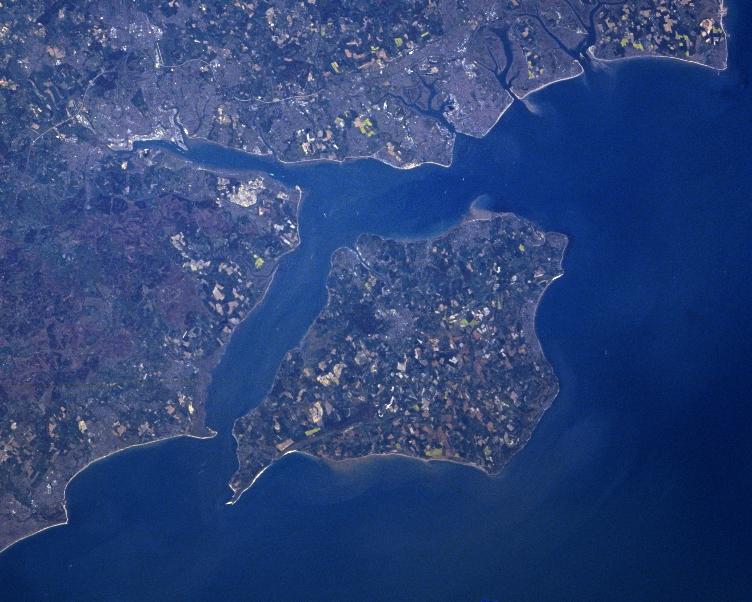
Isle of Wight satellite image

Adapted from:

Earth Sciences and Image Analysis, NASA-Johnson Space Center. 19 Oct. 2004. "Earth from Space - Image Information." <http://earth.jsc.nasa.gov/sseop/efs/photoinfo.pl?PHOTO=NM23-762-210> (7 Nov. 2004).


Public domainPublic domainfalsefalse
Public domain This file is in the public domain in the United States because it was solely created by NASA. NASA copyright policy states that "NASA material is not protected by copyright unless noted". (See Template:PD-USGov, NASA copyright policy page or JPL Image Use Policy.)
Warnings:
  • Use of NASA logos, insignia and emblems is restricted per U.S. law 14 CFR 1221.
  • The NASA website hosts a large number of images from the Soviet/Russian space agency, and other non-American space agencies. These are not necessarily in the public domain.
  • Materials based on Hubble Space Telescope data may be copyrighted if they are not explicitly produced by the STScI.[1] See also {{PD-Hubble}} and {{Cc-Hubble}}.
  • The SOHO (ESA & NASA) joint project implies that all materials created by its probe are copyrighted and require permission for commercial non-educational use. [2]
  • Images featured on the Astronomy Picture of the Day (APOD) web site may be copyrighted. [3]
  • The National Space Science Data Center (NSSDC) site has been known to host copyrighted content. Its photo gallery FAQ states that all of the images in the photo gallery are in the public domain "Unless otherwise noted."

Başlıqlar

Bu faylın nəyi təmsil etdiyinə dair bir sətirlik izahat əlavə et

Bu faylda təsvir olunan elementlər

təsvir edir

copyright status ingilis

ictimai mülkiyyət

yurisdiksiyasındadır: Amerika Birləşmiş Ştatları
təyinetmə üsulu: work of the federal government of the United States ingilis

media type ingilis

image/png

Faylın tarixçəsi

Faylın əvvəlki versiyasını görmək üçün gün/tarix bölməsindəki tarixlərə klikləyin.

Tarix/VaxtMiniatürÖlçülərİstifadəçiŞərh
hal-hazırkı15:34, 31 iyul 201715:34, 31 iyul 2017 tarixindəki versiyanın miniatür görüntüsü2.500 × 2.000 (8,01 MB)Szczureqfull resolution
11:36, 8 fevral 201311:36, 8 fevral 2013 tarixindəki versiyanın miniatür görüntüsü396 × 285 (217 KB)SoerfmBrightness
19:10, 25 mart 200519:10, 25 mart 2005 tarixindəki versiyanın miniatür görüntüsü396 × 285 (195 KB)Marknew{{PD-USGov-NASA}}

Faylın istifadəsi

Aşağıdakı səhifə bu faylı istifadə edir:

  • Solent

Faylın qlobal istifadəsi

Bu fayl aşağıdakı vikilərdə istifadə olunur:

  • ar.wikipedia.org layihəsində istifadəsi
    • سولنت
  • bg.wikipedia.org layihəsində istifadəsi
    • Уайт
  • br.wikipedia.org layihəsində istifadəsi
    • Solent
  • ca.wikipedia.org layihəsində istifadəsi
    • Southampton
    • Solent
  • ceb.wikipedia.org layihəsində istifadəsi
    • Spithead (agianan)
    • The Solent
  • cs.wikipedia.org layihəsində istifadəsi
    • Solentská úžina
  • da.wikipedia.org layihəsində istifadəsi
    • Isle of Wight
    • The Solent
  • de.wikipedia.org layihəsində istifadəsi
    • The Solent
    • Southampton Water
    • Spithead
    • Clausentum
    • Liste der Inseln in England
    • Round the Island Race
  • en.wikipedia.org layihəsində istifadəsi
    • The Solent
    • List of islands of England
    • Geography of England
    • Round the Island Race
    • Wikipedia:Featured article candidates/New Forest pony/archive1
    • Wikipedia:Featured article candidates/Featured log/June 2012
  • es.wikipedia.org layihəsində istifadəsi
    • Isla de Wight
    • Aelle de Sussex
    • Solent
    • Anexo:Islas de Inglaterra
    • Spithead
  • et.wikipedia.org layihəsində istifadəsi
    • Solenti väin
  • eu.wikipedia.org layihəsində istifadəsi
    • Solent
  • fa.wikipedia.org layihəsində istifadəsi
    • جزیره وایت
  • fi.wikipedia.org layihəsində istifadəsi
    • Solent
  • fr.wikipedia.org layihəsində istifadəsi
    • Portsmouth
    • Liste des îles d'Angleterre
    • Spithead
    • The Solent
  • gl.wikipedia.org layihəsində istifadəsi
    • Ælle de Sussex
  • he.wikipedia.org layihəsində istifadəsi
    • קרב סולנט
    • האי וייט (תעלת למאנש)
    • ספיטהד
    • סולנט
  • id.wikipedia.org layihəsində istifadəsi
    • Geografi Inggris
    • Daftar pulau di Inggris
  • it.wikipedia.org layihəsində istifadəsi
    • Isola di Wight
    • Solent (canale)
    • Spithead
    • I conquistatori (romanzo)
  • ja.wikipedia.org layihəsində istifadəsi
    • ワイト島
    • ソレント海峡
    • スピットヘッド
  • km.wikipedia.org layihəsində istifadəsi
    • វ៉ែត

Bu faylın qlobal istifadəsinə baxın.

Metaməlumatlar

Bu faylda fotoaparat və ya skanerlə əlavə olunmuş məlumatlar var. Əgər fayl sonradan olunubsa, bəzi parametrlər bu şəkildə göstərilənlərdən fərqli ola bilər.

Üfüqi xətt28,34 dpc
Şaquli xətt28,34 dpc
Mənbə — "https://az.wikipedia.org/wiki/Fayl:Wight.png"
Informasiya Melumat Axtar