Daha yüksək versiyası yoxdur.
Water_Level_Route_on_US_map_cropped.png (675 × 466 piksel, fayl həcmi: 176 KB, MIME növü: image/png)
Bu fayl Vikianbarda yerləşir. Açıqlama səhifəsindəki məlumatlar aşağıda göstərilib. Vikianbar azad lisenziyalı media anbarıdır. Siz də töhfə verə bilərsiniz. |
Xülasə
| İzah |
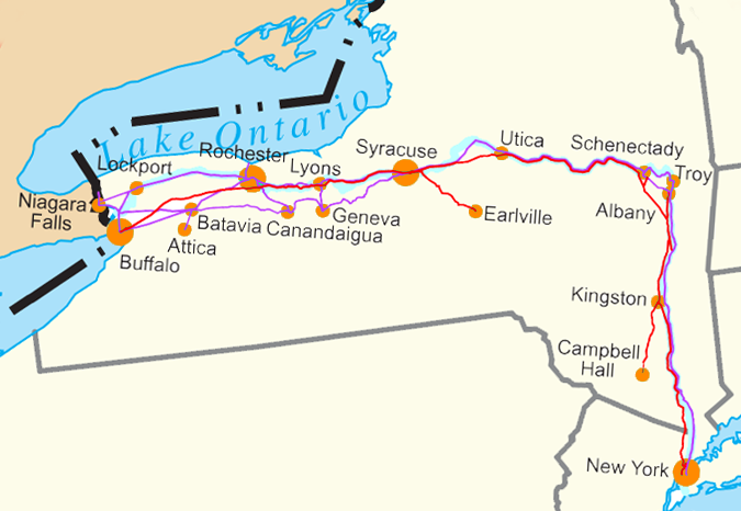
English: Water Level Routes of the New York Central Railroad, West Shore Railroad and Erie Canal on Image:US state outline map.png. See Image:Water Level Route on US map.png for the full U.S. |
| Tarix | |
| Mənbə | Öz işi |
| Müəllif | SPUI |
| Digər versiyalar | Image:Water Level Route on US map.png - uncropped version. |
This transport map image could be re-created using vector graphics as an SVG file. This has several advantages; see Commons:Media for cleanup for more information. If an SVG form of this image is available, please upload it and afterwards replace this template with
{{vector version available|new image name}}.It is recommended to name the SVG file “Water Level Route on US map cropped.svg”—then the template Vector version available (or Vva) does not need the new image name parameter. |
Lisenziya
| This work has been released into the public domain by its author, SPUI. This applies worldwide. In some countries this may not be legally possible; if so: |
Faylın tarixçəsi
Faylın əvvəlki versiyasını görmək üçün gün/tarix bölməsindəki tarixlərə klikləyin.
| Tarix/Vaxt | Miniatür | Ölçülər | İstifadəçi | Şərh | |
|---|---|---|---|---|---|
| hal-hazırkı | 17:23, 2 iyul 2018 | | 675 × 466 (176 KB) | Ɱ | toning colors |
| 19:45, 3 iyul 2005 |  | 679 × 358 (27 KB) | SPUI~commonswiki | {{spuimap}} Water Level Routes of the New York Central Railroad, West Shore Railroad and Erie Canal on Image:US state outline map.png. See Image:Water Level Route on US map.png for the full U.S. category:New York Central Railroad [[categor |
Faylın istifadəsi
Aşağıdakı səhifə bu faylı istifadə edir:
Faylın qlobal istifadəsi
Bu fayl aşağıdakı vikilərdə istifadə olunur:
- ba.wikipedia.org layihəsində istifadəsi
- en.wikipedia.org layihəsində istifadəsi
- fr.wikipedia.org layihəsində istifadəsi
- ga.wikipedia.org layihəsində istifadəsi
- he.wikipedia.org layihəsində istifadəsi
- ja.wikipedia.org layihəsində istifadəsi
- mk.wikipedia.org layihəsində istifadəsi
- pt.wikipedia.org layihəsində istifadəsi
- ro.wikipedia.org layihəsində istifadəsi
- ru.wikipedia.org layihəsində istifadəsi
- sv.wikipedia.org layihəsində istifadəsi
- tr.wikipedia.org layihəsində istifadəsi
- uk.wikipedia.org layihəsində istifadəsi