Sınaq göstərişi ölçüsü: 557 × 600 piksel. Digər ölçülər: 223 × 240 piksel | 446 × 480 piksel | 713 × 768 piksel | 951 × 1.024 piksel | 2.007 × 2.161 piksel.
Faylın orijinalı (2.007 × 2.161 piksel, fayl həcmi: 1,34 MB, MIME növü: image/png)
Bu fayl Vikianbarda yerləşir. Açıqlama səhifəsindəki məlumatlar aşağıda göstərilib. Vikianbar azad lisenziyalı media anbarıdır. Siz də töhfə verə bilərsiniz. |
This map image could be re-created using vector graphics as an SVG file. This has several advantages; see Commons:Media for cleanup for more information. If an SVG form of this image is available, please upload it and afterwards replace this template with
{{vector version available|new image name}}.It is recommended to name the SVG file “WW2-Holocaust-Poland.svg”—then the template Vector version available (or Vva) does not need the new image name parameter. |
Xülasə
| İzah |
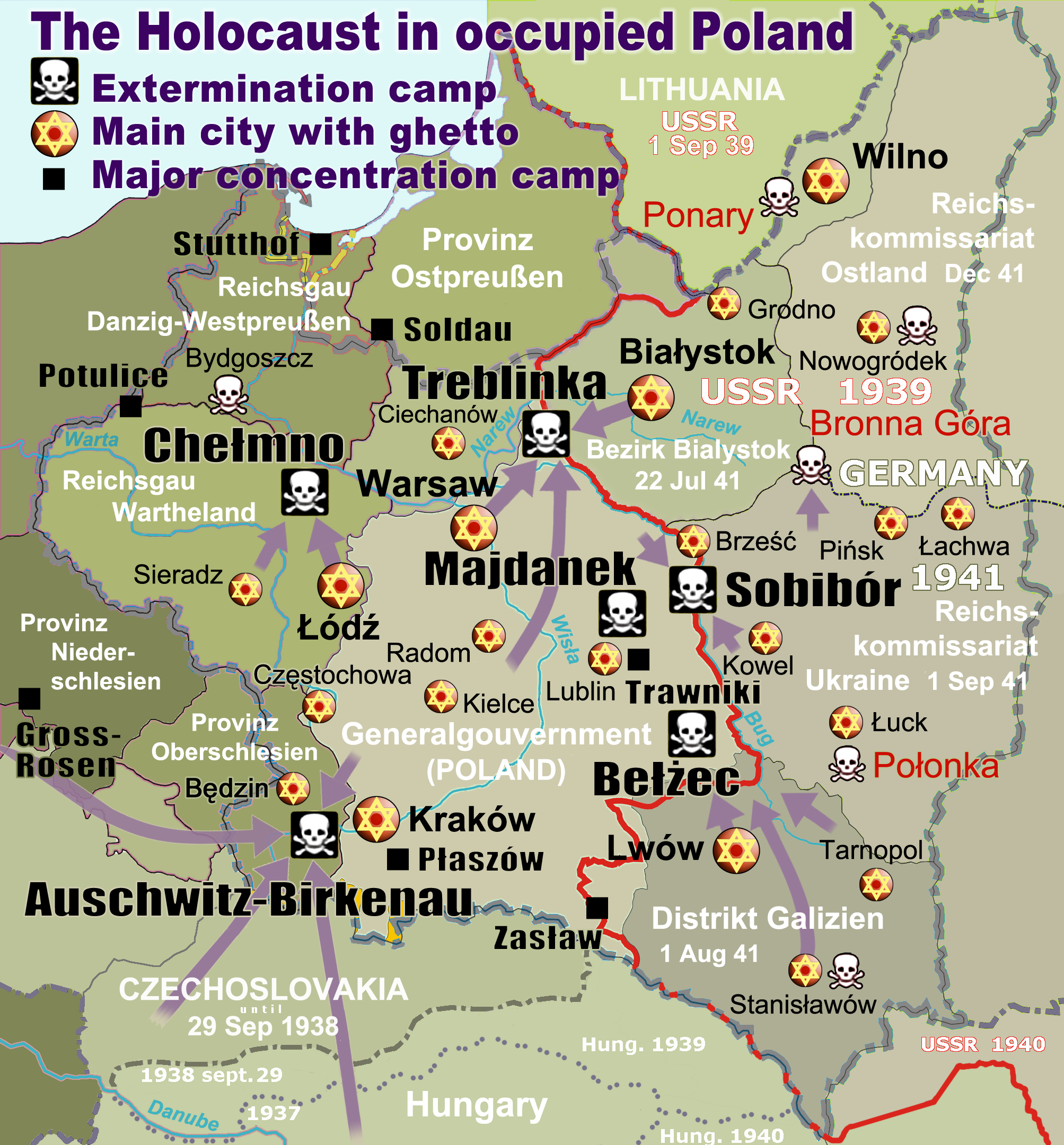
English: Map of the Holocaust in occupied Poland during World War II. The outline shows the borders of the Second Polish Republic at the time of the Nazi-German-and-Soviet invasion of Poland in 1939 with demarcation line between the two invading armies marked in red. Internal boundaries show the administrative divisions of occupied territories imposed by Nazi Germany when the Final Solution was set in motion during and after Operation Barbarossa of 1941. This map shows all Nazi German extermination camps (or death camps), as well as prominent concentration, labour and prison camps, major pre-WW2 Polish cities with the new Jewish ghettos set up by Nazi Germany, major deportation routes, and major massacre sites. Notes: 1. Extermination camps – marked with white skulls in black squares – are six dedicated facilities used for the mass gassings of prisoners, but all camps and ghettos took a toll of many, many lives. 2. Concentration camps – marked with black squares – feature only the most notorious forced-labor camps, prison camps & transit camps. 3. Sites of mass shootings into remote ravines – marked with white skulls – include Bronna Góra, Ponary and others. They were utilized during the 'Holocaust by bullets'. 4. Destruction ghettos – marked with Yellow stars in red circles – existed in most Polish cities. Only a selection is shown. 5. Major deportation routes travelled by the Holocaust trains are marked with RosyBrown arrows. 6. Most camps & ghettos which are not well known have been excluded for clarity. 7. District borders are at the height of Axis domination (1942). 8. Regions have German designations (e.g. "Ostland"), with the country name denoted in uppercase letters, e.g. LITHUANIA, CZECHOSLOVAKIA, or in parenthesis below the German occupational designation, e.g. (POLAND). |
| Tarix | |
| Mənbə |
Öz işi. Composite map derived from a variety of readily available sources which may or may not include:
|
| Müəllif |
|
| İcazə (Faylın təkrar istifadəsi) |
PD, see below. The map is completely unrestricted for any Wikipedia/Wikimedia project. |
| Digər versiyalar |
[]
|


.png)


.png)


Lisenziya
For all derivative works of maps uploaded earlier see below.
Poeticbent (en), the copyright holder of this work, hereby publishes it under the following license:
| This work has been released into the public domain by its author, Poeticbent (en). This applies worldwide. In some countries this may not be legally possible; if so: Poeticbent (en) grants anyone the right to use this work for any purpose, without any conditions, unless such conditions are required by law. |
- File uploaded previously
Dennis Nilsson, the copyright holder of this work, hereby publishes it under the following license:
Bu fayl Creative Commons Attribution 3.0 Unported lisenziyası altında yayımlanır.
Atribut:
Dennis Nilsson
- Siz heç bir məhdudiyyət olmadan:
- paylaşa bilərsiniz – əsəri köçürə, paylaya və ötürə bilərsiniz
- remiks edə bilərsiniz – əsəri adaptasiya edə bilərsiniz
- Aşağıdakı şərtlərə əməl etməklə:
- istinad vermək – Müvafiq istinad verməli, lisenziyaya keçid əlavə etməli və dəyişikliklər edilib-edilmədiyini bildirməlisiniz . Siz bunu istənilən şəkildə edə bilərsiniz, lakin lisenziya verənin sizə şəxsən icazə verdiyini göstərən formada yox.
Derivative work: Piotr Konieczny aka Prokonsul Piotrus Talk Derivative works of this file:
Derivative work: User:Poeticbent (Talk) Derivative works of this file:
- Uploaded previously
| Bu təsvirin si, orijinala əsaslanaraq rəqəmsal qaydadadır. Dəyişiklik: Smaller version: occupied Poland only (pre-WWII borders). İlkin təsvir buradadır: WW2-Holocaust-Europe.png.
|
Mən, bu işin müəllif hüquqları sahibi, onu aşağıdakı lisenziyaya əsasən dərc edirəm:
Bu fayl Creative Commons Attribution 3.0 Unported lisenziyası altında yayımlanır.
- Siz heç bir məhdudiyyət olmadan:
- paylaşa bilərsiniz – əsəri köçürə, paylaya və ötürə bilərsiniz
- remiks edə bilərsiniz – əsəri adaptasiya edə bilərsiniz
- Aşağıdakı şərtlərə əməl etməklə:
- istinad vermək – Müvafiq istinad verməli, lisenziyaya keçid əlavə etməli və dəyişikliklər edilib-edilmədiyini bildirməlisiniz . Siz bunu istənilən şəkildə edə bilərsiniz, lakin lisenziya verənin sizə şəxsən icazə verdiyini göstərən formada yox.
Orijinal yükləmə gündəliyi
For derivative works of the first uploaded file created by User:Dna-webmaster see the following:
- File:WW2-Holocaust-Europe.png licensed with Cc-by-3.0
Uploaded with derivativeFX
Faylın tarixçəsi
Faylın əvvəlki versiyasını görmək üçün gün/tarix bölməsindəki tarixlərə klikləyin.
| Tarix/Vaxt | Miniatür | Ölçülər | İstifadəçi | Şərh | |
|---|---|---|---|---|---|
| hal-hazırkı | 15:46, 10 mart 2020 | | 2.007 × 2.161 (1,34 MB) | Claude Zygiel | Cosmetics |
| 20:33, 28 mart 2018 |  | 2.007 × 2.161 (1,48 MB) | Poeticbent | not an improvement: img looks muddy but I have original Photoshop layers, and can adjust them individually; comment on specifics in talk please | |
| 17:48, 27 mart 2018 |  | 2.007 × 2.161 (1,49 MB) | Hohum | Too much information competing for attention in a very busy image. Toned down region name brightness, desaturated slightly. | |
| 05:38, 10 iyul 2017 |  | 2.007 × 2.161 (1,48 MB) | Poeticbent | vital updates following a discussion → prominent ghettos, legend | |
| 19:43, 25 iyul 2015 |  | 2.007 × 2.161 (1,46 MB) | Poeticbent | name of settlement: Górka Połonka, source Wolyn.ovh.org | |
| 18:27, 2 dekabr 2014 |  | 2.007 × 2.161 (1,46 MB) | Poeticbent | added one missing marker | |
| 19:17, 7 may 2014 |  | 2.007 × 2.161 (1,45 MB) | Poeticbent | location of Bronna Góra | |
| 17:34, 4 aprel 2014 |  | 2.007 × 2.161 (1,44 MB) | Poeticbent | Lachwa Ghetto location | |
| 21:31, 27 iyun 2013 |  | 2.007 × 2.161 (1,42 MB) | Poeticbent | major expansion with similar color-scheme | |
| 03:09, 28 iyun 2011 |  | 364 × 339 (123 KB) | LMK3 | changed the color of the Soviet Curzon line to indicate the two different occupation zones before Operation Barbarossa, refined the location of Warsaw |
Faylın istifadəsi
Aşağıdakı səhifə bu faylı istifadə edir:
Faylın qlobal istifadəsi
Bu fayl aşağıdakı vikilərdə istifadə olunur:
- ar.wikipedia.org layihəsində istifadəsi
- azb.wikipedia.org layihəsində istifadəsi
- bg.wikipedia.org layihəsində istifadəsi
- bn.wikipedia.org layihəsində istifadəsi
- br.wikipedia.org layihəsində istifadəsi
- ca.wikipedia.org layihəsində istifadəsi
- cs.wikipedia.org layihəsində istifadəsi
- cs.wikibooks.org layihəsində istifadəsi
- da.wikipedia.org layihəsində istifadəsi
- de.wikipedia.org layihəsində istifadəsi
- el.wikipedia.org layihəsində istifadəsi
- Γκέτο της Τσενστοχόβα
- Γκέτο του Μπέντζιν
- Γκέτο του Μίζοτς
- Μπρόνα Γκούρα
- Γκέτο της Κρακοβίας
- Γκέτο του Μπζέσκο
- Στρατόπεδο συγκέντρωσης Τραβνίκι
- Στρατόπεδο συγκέντρωσης Ποτουλίτσε
- Γκέτο του Σοσνόβιετς
- Γκέτο του Ντροχόμπιτς
- Γκέτο του Ταρνόπολ
- Ιστορία των Εβραίων στην Πολωνία
- Γκέτο του Σιέντλτσε
- Γκέτο του Γκορλίτσε
- Γκέτο του Μπιαουίστοκ
- Γκέτο του Μπζεστς
- Γκέτο του Ράντομ
- Γκέτο του Νόβι Σοντς
- Τουρισμός του Ολοκαυτώματος
- en.wikipedia.org layihəsində istifadəsi
Bu faylın qlobal istifadəsinə baxın.