
Bu fayl Vikianbarda yerləşir. Açıqlama səhifəsindəki məlumatlar aşağıda göstərilib. Vikianbar azad lisenziyalı media anbarıdır. Siz də töhfə verə bilərsiniz. |
Xülasə
| İzah |
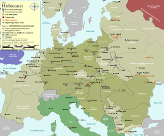
Map of the Holocaust in Europe during World War II, 1939-1945.
|
| Tarix | |
| Mənbə | Self-made by User:Dna-Dennis, using information from USHMM & Wikipedia. |
| Müəllif | User:Dna-Dennis |
| İcazə (Faylın təkrar istifadəsi) |
CC, see below. The map is completely unrestricted for any Wikipedia/Wikimedia project. |
| Digər versiyalar |
[]
|


.png)


.png)


.png)

|
File:WW2 Holocaust Europe map-fr.svg is a vector version of this file. It should be used in place of this PNG file when not inferior.
File:WW2-Holocaust-Europe.png → File:WW2 Holocaust Europe map-fr.svg
For more information, see Help:SVG. |
 |
Lisenziya
- Siz heç bir məhdudiyyət olmadan:
- paylaşa bilərsiniz – əsəri köçürə, paylaya və ötürə bilərsiniz
- remiks edə bilərsiniz – əsəri adaptasiya edə bilərsiniz
- Aşağıdakı şərtlərə əməl etməklə:
- istinad vermək – Müvafiq istinad verməli, lisenziyaya keçid əlavə etməli və dəyişikliklər edilib-edilmədiyini bildirməlisiniz . Siz bunu istənilən şəkildə edə bilərsiniz, lakin lisenziya verənin sizə şəxsən icazə verdiyini göstərən formada yox.
Faylın tarixçəsi
Faylın əvvəlki versiyasını görmək üçün gün/tarix bölməsindəki tarixlərə klikləyin.
| Tarix/Vaxt | Miniatür | Ölçülər | İstifadəçi | Şərh | |
|---|---|---|---|---|---|
| hal-hazırkı | 13:57, 29 oktyabr 2009 | | 1.310 × 1.090 (639 KB) | Flying Saucer | moved Vaivara to it's right place |
| 03:41, 20 dekabr 2007 |  | 1.310 × 1.090 (826 KB) | Dna-webmaster~commonswiki | new version without "Axis cooperating" in legend | |
| 02:00, 20 dekabr 2007 |  | 1.310 × 1.090 (824 KB) | Dna-webmaster~commonswiki | Now entire West Prussia and Wartheland is included in the Third Reich | |
| 16:42, 19 dekabr 2007 |  | 1.310 × 1.090 (828 KB) | Dna-webmaster~commonswiki | still not Da Vinci, but errors have been corrected (Germany borders West/East), West & East Prussia borders/coloring and Poland General Government corrected borders. | |
| 10:46, 17 dekabr 2007 |  | 1.310 × 1.090 (825 KB) | Dna-webmaster~commonswiki | new map with 1942 borders, not Da Vinci, but here it goes... | |
| 13:32, 19 oktyabr 2007 |  | 1.310 × 1.090 (766 KB) | Dna-webmaster~commonswiki | and another update | |
| 12:21, 19 oktyabr 2007 |  | 1.310 × 1.090 (771 KB) | Dna-webmaster~commonswiki | quick fix | |
| 12:11, 19 oktyabr 2007 |  | 1.310 × 1.090 (771 KB) | Dna-webmaster~commonswiki | {{Information |Description=Map of the Holocaust in Europe during World War II, 1939-1945. <br> This map shows all extermination camps (or ''death camps''), most major concentration camps, work camps, prison camps, ghettos, major deportation routes and maj |
Faylın istifadəsi
Aşağıdakı səhifə bu faylı istifadə edir:
Faylın qlobal istifadəsi
Bu fayl aşağıdakı vikilərdə istifadə olunur:
- af.wikipedia.org layihəsində istifadəsi
- ar.wikipedia.org layihəsində istifadəsi
- be-tarask.wikipedia.org layihəsində istifadəsi
- be.wikipedia.org layihəsində istifadəsi
- bn.wikipedia.org layihəsində istifadəsi
- ca.wikipedia.org layihəsində istifadəsi
- crh.wikipedia.org layihəsində istifadəsi
- cs.wikipedia.org layihəsində istifadəsi
- da.wikipedia.org layihəsində istifadəsi
- de.wikipedia.org layihəsində istifadəsi
- el.wikipedia.org layihəsində istifadəsi
- en.wikipedia.org layihəsində istifadəsi
- Auschwitz concentration camp
- Extermination camp
- Sobibor extermination camp
- Drancy internment camp
- White Buses
- Vel' d'Hiv roundup
- Template:Image frame
- German war crimes
- René Bousquet
- Holocaust trains
- Mechelen transit camp
- User:Dna-webmaster/Projects
- Jewish ghettos in Europe
- List of Jewish ghettos in Europe during World War II
- Template:Image frame/doc
- User:Jnestorius/Resources
- Wikipedia:Featured picture candidates/January-2015
- Wikipedia:Featured picture candidates/Map of the Holocaust in Europe
- The Holocaust in Hungary
- Emigration of Jews from Nazi Germany and German-occupied Europe
- Talk:The Holocaust/Archive 31
- Template:Image frame/sandbox
- Reich Security Main Office Referat IV B4
- Genocides in history (World War I through World War II)
- User:Buidhe/fork
- en.wikibooks.org layihəsində istifadəsi
- es.wikipedia.org layihəsində istifadəsi
- fa.wikipedia.org layihəsində istifadəsi
- fi.wikipedia.org layihəsində istifadəsi
- fi.wikibooks.org layihəsində istifadəsi
Bu faylın qlobal istifadəsinə baxın.