Sınaq göstərişi ölçüsü: 800 × 577 piksel. Digər ölçülər: 320 × 231 piksel | 640 × 461 piksel | 1.011 × 729 piksel.
Faylın orijinalı (1.011 × 729 piksel, fayl həcmi: 89 KB, MIME növü: image/png)
Bu fayl Vikianbarda yerləşir. Açıqlama səhifəsindəki məlumatlar aşağıda göstərilib. Vikianbar azad lisenziyalı media anbarıdır. Siz də töhfə verə bilərsiniz. |
This map image could be re-created using vector graphics as an SVG file. This has several advantages; see Commons:Media for cleanup for more information. If an SVG form of this image is available, please upload it and afterwards replace this template with
{{vector version available|new image name}}.It is recommended to name the SVG file “United States Minor Outlying Islands.svg”—then the template Vector version available (or Vva) does not need the new image name parameter. |
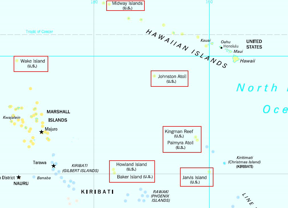
English: United States Minor Outlying Islands in the Pacific Ocean higlighted from public domain map. Note: There is also Navassa Island in the Caribbean.
This work is in the public domain in the United States because it is a work prepared by an officer or employee of the United States Government as part of that person’s official duties under the terms of Title 17, Chapter 1, Section 105 of the US Code.
Note: This only applies to original works of the Federal Government and not to the work of any individual U.S. state, territory, commonwealth, county, municipality, or any other subdivision. This template also does not apply to postage stamp designs published by the United States Postal Service since 1978. (See § 313.6(C)(1) of Compendium of U.S. Copyright Office Practices). It also does not apply to certain US coins; see The US Mint Terms of Use.
|
||
| Bu fayl bütün əlaqəli və qonşu hüquqlar da daxil olmaqla, müəllif hüquqları qanununa əsasən məlum məhdudiyyətlərdən azad olduğu müəyyən edilmişdir. | ||
Faylın tarixçəsi
Faylın əvvəlki versiyasını görmək üçün gün/tarix bölməsindəki tarixlərə klikləyin.
| Tarix/Vaxt | Miniatür | Ölçülər | İstifadəçi | Şərh | |
|---|---|---|---|---|---|
| hal-hazırkı | 17:20, 3 mart 2009 | | 1.011 × 729 (89 KB) | Kmusser | Changed the Midway box so that it doesn't include Kure Atoll |
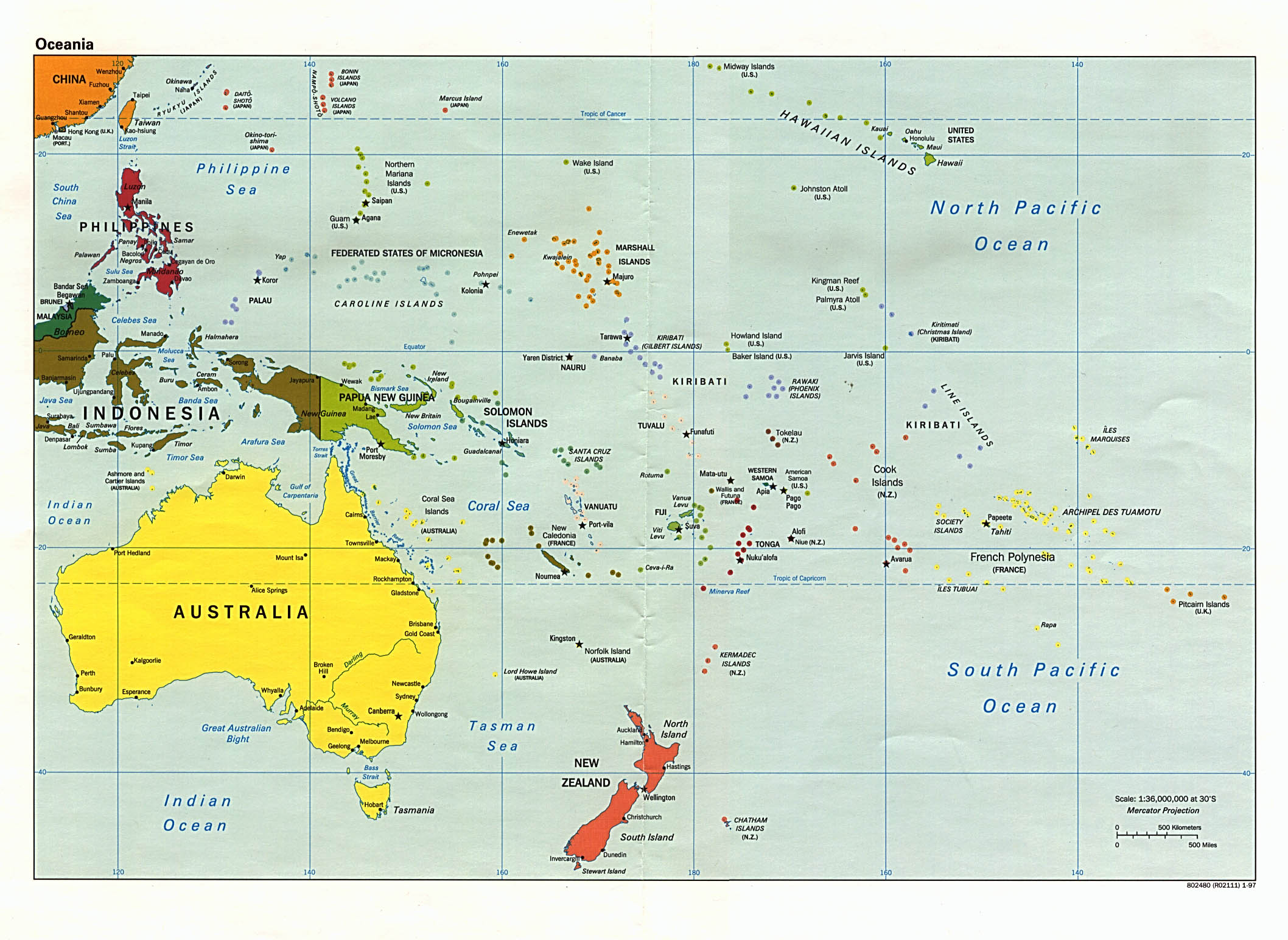
| 10:34, 7 mart 2007 |  | 1.011 × 729 (68 KB) | Roke~commonswiki | United States Minor Outlying Islands higlighted from [http://www.lib.utexas.edu/maps/islands_oceans_poles/oceania_pol_97.jpg public domain map] {{PD-PCL|/oceania_pol_97.jpg|islands_oceans_poles}} |
Faylın istifadəsi
Aşağıdakı səhifə bu faylı istifadə edir:
Faylın qlobal istifadəsi
Bu fayl aşağıdakı vikilərdə istifadə olunur:
- af.wikipedia.org layihəsində istifadəsi
- ar.wikipedia.org layihəsində istifadəsi
- bg.wikipedia.org layihəsində istifadəsi
- bs.wikipedia.org layihəsində istifadəsi
- ca.wikipedia.org layihəsində istifadəsi
- ckb.wikipedia.org layihəsində istifadəsi
- cy.wikipedia.org layihəsində istifadəsi
- da.wikipedia.org layihəsində istifadəsi
- de.wikipedia.org layihəsində istifadəsi
- el.wikipedia.org layihəsində istifadəsi
- en.wikipedia.org layihəsində istifadəsi
- United States Minor Outlying Islands
- List of state and territory name etymologies of the United States
- List of regions of the United States
- ISO 3166-2:UM
- National Register of Historic Places listings in the United States Minor Outlying Islands
- User:Jeff in CA/US Territorial Acquisitions
- User:Falcaorib/Canada, United States and Mexico
- eo.wikipedia.org layihəsində istifadəsi
- es.wikipedia.org layihəsində istifadəsi
- fa.wikipedia.org layihəsində istifadəsi
- fi.wikipedia.org layihəsində istifadəsi
- fo.wikipedia.org layihəsində istifadəsi
- fr.wikipedia.org layihəsində istifadəsi
- fr.wiktionary.org layihəsində istifadəsi
- hr.wikipedia.org layihəsində istifadəsi
- hu.wikipedia.org layihəsində istifadəsi
- ia.wikipedia.org layihəsində istifadəsi
- id.wikipedia.org layihəsində istifadəsi
- incubator.wikimedia.org layihəsində istifadəsi
- ka.wikipedia.org layihəsində istifadəsi
- kk.wikipedia.org layihəsində istifadəsi
- ko.wikipedia.org layihəsində istifadəsi
- ky.wikipedia.org layihəsində istifadəsi
- lv.wikipedia.org layihəsində istifadəsi
- mk.wikipedia.org layihəsində istifadəsi
- nl.wikipedia.org layihəsində istifadəsi
- no.wikipedia.org layihəsində istifadəsi
- pl.wikipedia.org layihəsində istifadəsi
Bu faylın qlobal istifadəsinə baxın.