Butun axtardiqlarinizi tapmaq ucun buraya: DAXIL OLUN
  Mp4 Mp3 Axtar Yukle
  Video Axtar Yukle
  Shekil Axtar Yukle
  Informasiya Melumat Axtar
  Hazir Inshalar Toplusu
  AZERI CHAT + Tanishliq
  1-11 Sinif Derslikler Yukle
  Saglamliq Tibbi Melumat
  Whatsapp Plus Yukle(Yeni)

  • Ana səhifə
  • Təsadüfi
  • Yaxınlıqdakılar
  • Daxil ol
  • Nizamlamalar
İndi ianə et Əgər Vikipediya sizin üçün faydalıdırsa, bu gün ianə edin.

Fayl:Thermohaline Circulation 2.png

  • Fayl
  • Müzakirə
  • Vikianbar üzərindən baxış
  • Lokal izah əlavə et
  • Fayl
  • Faylın tarixçəsi
  • Faylın istifadəsi
  • Faylın qlobal istifadəsi
Fayl:Thermohaline Circulation 2.png
Sınaq göstərişi ölçüsü: 800 × 502 piksel. Digər ölçülər: 320 × 201 piksel | 640 × 401 piksel | 1.100 × 690 piksel.
Faylın orijinalı (1.100 × 690 piksel, fayl həcmi: 122 KB, MIME növü: image/png)
Bu fayl Vikianbarda yerləşir. Açıqlama səhifəsindəki məlumatlar aşağıda göstərilib.
Vikianbar azad lisenziyalı media anbarıdır. Siz də töhfə verə bilərsiniz.

Xülasə

İzahThermohaline Circulation 2.png
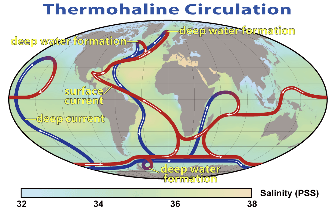
English: This map shows the pattern of thermohaline circulation also known as "meridional overturning circulation". This collection of currents is responsible for the large-scale exchange of water masses in the ocean, including providing oxygen to the deep ocean. The entire circulation pattern takes ~2000 years.
Deutsch: Thermohaline Zirkulation und die Entstehung von kaltem, dichtem Tiefenwasser im Nordmeer
Tarix 29 mart 2008
Mənbə NASA Earth Observatory
Müəllif Robert Simmon, NASA. Minor modifications by Robert A. Rohde also released to the public domain
İcazə
(Faylın təkrar istifadəsi)
Public domainPublic domainfalsefalse
Public domain This file is in the public domain in the United States because it was solely created by NASA. NASA copyright policy states that "NASA material is not protected by copyright unless noted". (See Template:PD-USGov, NASA copyright policy page or JPL Image Use Policy.)
Warnings:
  • Use of NASA logos, insignia and emblems is restricted per U.S. law 14 CFR 1221.
  • The NASA website hosts a large number of images from the Soviet/Russian space agency, and other non-American space agencies. These are not necessarily in the public domain.
  • Materials based on Hubble Space Telescope data may be copyrighted if they are not explicitly produced by the STScI.[1] See also {{PD-Hubble}} and {{Cc-Hubble}}.
  • The SOHO (ESA & NASA) joint project implies that all materials created by its probe are copyrighted and require permission for commercial non-educational use. [2]
  • Images featured on the Astronomy Picture of the Day (APOD) web site may be copyrighted. [3]
  • The National Space Science Data Center (NSSDC) site has been known to host copyrighted content. Its photo gallery FAQ states that all of the images in the photo gallery are in the public domain "Unless otherwise noted."
Digər versiyalar


This meteorology image could be re-created using vector graphics as an SVG file. This has several advantages; see Commons:Media for cleanup for more information. If an SVG form of this image is available, please upload it and afterwards replace this template with {{vector version available|new image name}}.
It is recommended to name the SVG file “Thermohaline Circulation 2.svg”—then the template Vector version available (or Vva) does not need the new image name parameter.

Başlıqlar

Bu faylın nəyi təmsil etdiyinə dair bir sətirlik izahat əlavə et

Bu faylda təsvir olunan elementlər

təsvir edir

copyright status ingilis

ictimai mülkiyyət

yurisdiksiyasındadır: Amerika Birləşmiş Ştatları
təyinetmə üsulu: work of the federal government of the United States ingilis

yaranma tarixi

29 mart 2008

data size ingilis

125.305 Bayt

hündürlüyü/boyu

690 piksel

eni

1.100 piksel

media type ingilis

image/png

checksum ingilis

651dd3545289464b33963c18809da0d5ca7f123d

təyinetmə üsulu: SHA-1

Faylın tarixçəsi

Faylın əvvəlki versiyasını görmək üçün gün/tarix bölməsindəki tarixlərə klikləyin.

Tarix/VaxtMiniatürÖlçülərİstifadəçiŞərh
hal-hazırkı20:08, 29 mart 200820:08, 29 mart 2008 tarixindəki versiyanın miniatür görüntüsü1.100 × 690 (122 KB)Dragons flight{{Information |Description=This map shows the pattern of w:thermohaline circulation also known as "meridional overturning circulation". This collection of currents is responsible for the large-scale exchange of water masses in the ocean, including p

Faylın istifadəsi

Aşağıdakı səhifə bu faylı istifadə edir:

  • Okeanologiya

Faylın qlobal istifadəsi

Bu fayl aşağıdakı vikilərdə istifadə olunur:

  • ar.wikipedia.org layihəsində istifadəsi
    • ساب أنتاركتيكا
    • توقف الدوران الحراري الملحي
    • تبعات الاحتباس الحراري
    • مستخدم:محمود محمد الشوبكى/ملعب8
  • ast.wikipedia.org layihəsində istifadəsi
    • Oceanografía física
    • Circulación termohalina
  • ba.wikipedia.org layihəsində istifadəsi
    • Океанология
  • bcl.wikipedia.org layihəsində istifadəsi
    • Biglaan na pagbago kan klima
  • be.wikipedia.org layihəsində istifadəsi
    • Тэрмахалінная цыркуляцыя
  • bg.wikipedia.org layihəsində istifadəsi
    • Море
    • Океан
    • Южен океан
  • bh.wikipedia.org layihəsində istifadəsi
    • समुंद्र बिज्ञान के रूपरेखा
  • bn.wikipedia.org layihəsində istifadəsi
    • সমুদ্রবিজ্ঞান
    • জলবায়ুর আকস্মিক পরিবর্তন
  • bs.wikipedia.org layihəsində istifadəsi
    • Anoksijski događaj
  • bxr.wikipedia.org layihəsində istifadəsi
    • Далай
  • ca.wikipedia.org layihəsində istifadəsi
    • Mar de Noruega
    • Regions HNLC
    • Circulació de retorn meridional de l'Atlàntic
  • cdo.wikipedia.org layihəsində istifadəsi
    • Hāi-iòng-hŏk
  • cs.wikipedia.org layihəsində istifadəsi
    • Anoxická událost
  • da.wikipedia.org layihəsində istifadəsi
    • Hav
    • Oceanografi
    • Hydrologi
    • Atlantic Meridional Overturning Circulation
  • da.wikibooks.org layihəsində istifadəsi
    • Hydrologi
    • Oceanografi
  • de.wikipedia.org layihəsində istifadəsi
    • Europäisches Nordmeer
    • Benutzer:Mistermeyer/Bildertest
  • el.wikipedia.org layihəsində istifadəsi
    • Ωκεανογραφία
    • Νορβηγική Θάλασσα
    • Μακροπρόθεσμες επιπτώσεις της κλιματικής αλλαγής
    • Απότομη κλιματική αλλαγή
  • en.wikipedia.org layihəsində istifadəsi
    • Norwegian Sea
    • Oceanography
    • Physical oceanography
    • Thermohaline circulation
    • Abrupt climate change
    • Environmental isotopes
    • Atlantic meridional overturning circulation
    • Subantarctic
    • Outline of oceanography
    • Wild fisheries
    • Talk:Geography
    • Sea
    • Ocean
    • User:Richard Hobbs/Seismic oceanography
    • User:Vivrkn/sandbox
    • Talk:Ice/GA1

Bu faylın qlobal istifadəsinə baxın.

Mənbə — "https://az.wikipedia.org/wiki/Fayl:Thermohaline_Circulation_2.png"
Informasiya Melumat Axtar