Daha yüksək versiyası yoxdur.
Teluk_Kayeli.jpg (177 × 178 piksel, fayl həcmi: 17 KB, MIME növü: image/jpeg)
Bu fayl Vikianbarda yerləşir. Açıqlama səhifəsindəki məlumatlar aşağıda göstərilib. Vikianbar azad lisenziyalı media anbarıdır. Siz də töhfə verə bilərsiniz. |
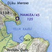
| İzah | Buru Island (Operational Navigation Chart) original scale 1:1,000,000. Portion of Defense Mapping Agency ONC M-12 1967 (152K) Not for navigational use |
| Tarix | (UTC) |
| Mənbə | |
| Müəllif |
|
| Bu təsvirin si, orijinala əsaslanaraq rəqəmsal qaydadadır. Dəyişiklik: crop. İlkin təsvir buradadır: Buru tpc 1967.jpg. etdi Insider.
|
This work is in the public domain in the United States because it is a work prepared by an officer or employee of the United States Federal Government as part of that person’s official duties under the terms of Title 17, Chapter 1, Section 105 of the US Code.
Note: This only applies to original works of the Federal Government and not to the work of any individual U.S. state, territory, commonwealth, county, municipality, or any other subdivision. This template also does not apply to postage stamp designs published by the United States Postal Service since 1978. (See § 313.6(C)(1) of Compendium of U.S. Copyright Office Practices). It also does not apply to certain US coins; see The US Mint Terms of Use.
|
||
| Bu fayl bütün əlaqəli və qonşu hüquqlar da daxil olmaqla, müəllif hüquqları qanununa əsasən məlum məhdudiyyətlərdən azad olduğu müəyyən edilmişdir. | ||
Orijinal yükləmə gündəliyi
This image is a derivative work of the following images:
- File:Buru_tpc_1967.jpg licensed with PD-USGov
- 2006-06-07T11:23:23Z File Upload Bot (Magnus Manske) 1057x797 (152064 Bytes) {{Information| |Description= Buru Island (Operational Navigation Chart) original scale 1:1,000,000. Portion of Defense Mapping Agency ONC M-12 1967 (152K) Not for navigational use {{PD-PCL|http://www.lib.utexas.edu/maps/mi
Uploaded with derivativeFX
Faylın tarixçəsi
Faylın əvvəlki versiyasını görmək üçün gün/tarix bölməsindəki tarixlərə klikləyin.
| Tarix/Vaxt | Miniatür | Ölçülər | İstifadəçi | Şərh | |
|---|---|---|---|---|---|
| hal-hazırkı | 11:14, 17 aprel 2010 | | 177 × 178 (17 KB) | Insider | {{Information |Description=Buru Island (Operational Navigation Chart) original scale 1:1,000,000. Portion of Defense Mapping Agency ONC M-12 1967 (152K) Not for navigational use {{PCL|http://www.lib.utexas.edu/maps/middle_east_and_asia/buru_tpc_1967.jpg |
Faylın istifadəsi
Aşağıdakı səhifə bu faylı istifadə edir:
Faylın qlobal istifadəsi
Bu fayl aşağıdakı vikilərdə istifadə olunur:
- en.wikipedia.org layihəsində istifadəsi
- fr.wikipedia.org layihəsində istifadəsi
- id.wikipedia.org layihəsində istifadəsi
- ka.wikipedia.org layihəsində istifadəsi
- nl.wikipedia.org layihəsində istifadəsi
- ru.wikipedia.org layihəsində istifadəsi
- simple.wikipedia.org layihəsində istifadəsi
- uk.wikipedia.org layihəsində istifadəsi
- vi.wikipedia.org layihəsində istifadəsi
- www.wikidata.org layihəsində istifadəsi