Sınaq göstərişi ölçüsü: 800 × 546 piksel. Digər ölçülər: 320 × 218 piksel | 640 × 437 piksel | 1.024 × 699 piksel | 1.280 × 874 piksel | 2.560 × 1.747 piksel | 6.740 × 4.600 piksel.
Faylın orijinalı (6.740 × 4.600 piksel, fayl həcmi: 4,95 MB, MIME növü: image/png)
Bu fayl Vikianbarda yerləşir. Açıqlama səhifəsindəki məlumatlar aşağıda göstərilib. Vikianbar azad lisenziyalı media anbarıdır. Siz də töhfə verə bilərsiniz. |
Xülasə
![[1]](https://en.wikipedia.org/wiki/File_talk:Plates_tect2_en.svg#Australian_&_Eurasian_Plates_over_Myanmar)
| İzah |
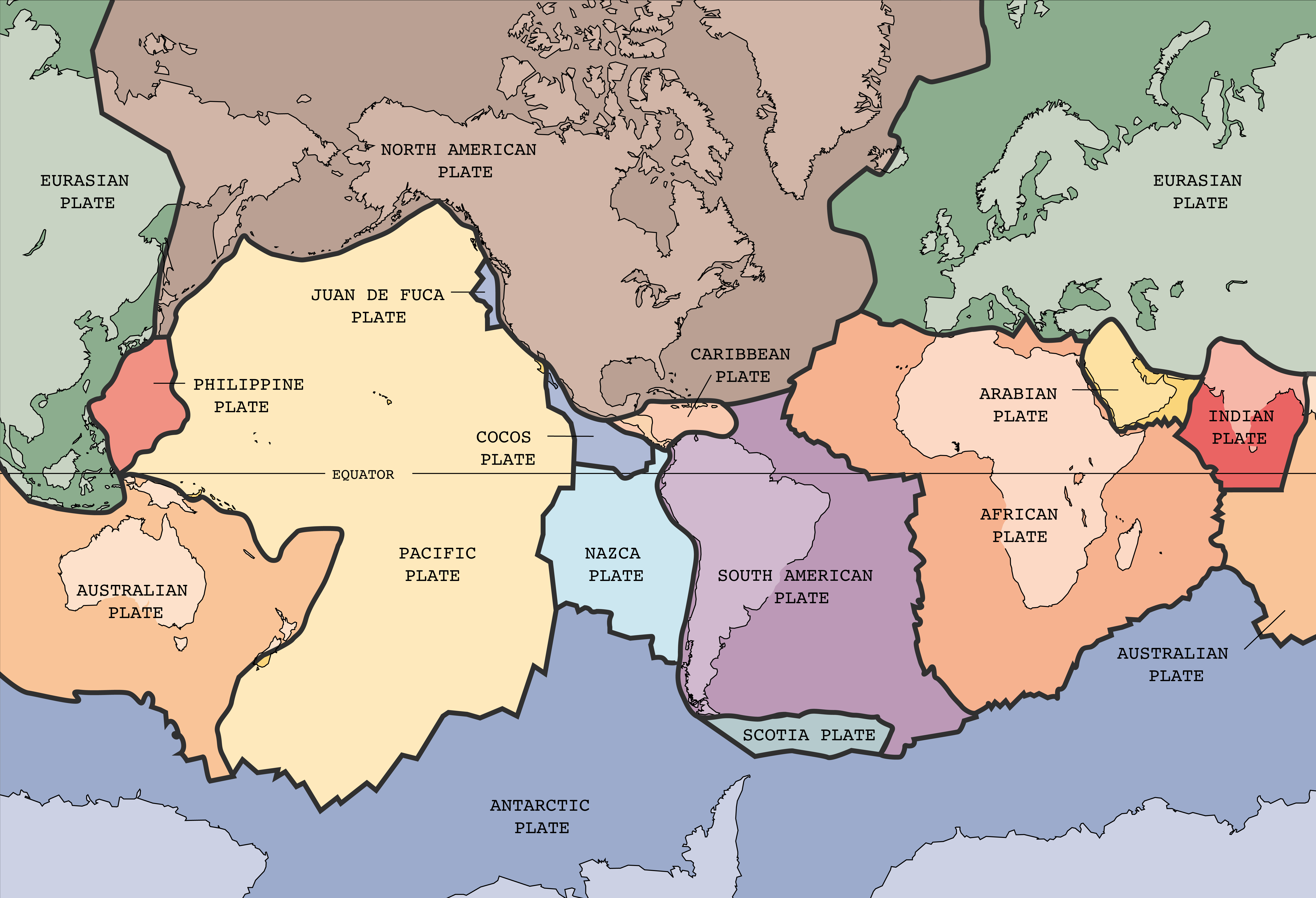
English: English text version of Image:Tectonic plates (empty).svg
Tectonic plates of the Earth. From wikipedia.en, retrieved from USGS site: http://pubs.usgs.gov/publications/text/slabs.html Original Image URL: [3] Listed contact: mailto:jmwatson@usgs.gov
|
| Tarix | 30 dekabr 2004 (upload date) |
| Mənbə | [4] |
| Müəllif |
|
| Digər versiyalar |
Derivative works of this file: |
.svg)
![[3]](https://pubs.usgs.gov/publications/graphics/Fig1.gif)
.png)
This image was selected as picture of the day on Wikimedia Commons for 20 February 2005. It was captioned as follows: English: Map of the tectonic plates of the Earth Other languages:
Čeština: Mapa tektonických desek Země Deutsch: Karte der tektonischen Platten der Erde English: Map of the tectonic plates of the Earth Español: Mapa de las placas tectónicas de la Tierra. Esperanto: Mapo de la tectonic teleroj de la tero Français : Carte des plaques tectoniques terrestres. Italiano: Mappa delle placche tettoniche della terra Lëtzebuergesch: Kaart vun den tektonesche Placke vun der Äerd. Nederlands: Kaart met de tektonische platen van de aarde Norsk bokmål: Kart over verdas tektoniske plater. Português: Mapa das placas tectônicas da Terra Suomi: Maapallon tektoniset laatat. Svenska: Karta över de tektoniska plattor som täcker jordens yta. Български: Карта на тектоничните плочи на Земята Русский: Карта тектонических плит 日本語: 地球の表面を覆うプレート 中文: 地球板块结构图 |

|
File:Plates tect2 en.svg is a vector version of this file. It should be used in place of this PNG file when not inferior.
File:Tectonic plates.png → File:Plates tect2 en.svg
For more information, see Help:SVG. |
 |
Lisenziya
This image is in the public domain in the United States because it only contains materials that originally came from the United States Geological Survey, an agency of the United States Department of the Interior. For more information, see the official USGS copyright policy.
|
Faylın tarixçəsi
Faylın əvvəlki versiyasını görmək üçün gün/tarix bölməsindəki tarixlərə klikləyin.
| Tarix/Vaxt | Miniatür | Ölçülər | İstifadəçi | Şərh | |
|---|---|---|---|---|---|
| hal-hazırkı | 21:10, 30 avqust 2024 | | 6.740 × 4.600 (4,95 MB) | RXFADEZ | restored Hispaniola to be a single island. Tried to preserve image format otherwise |
| 03:25, 4 fevral 2022 |  | 6.740 × 4.600 (4,45 MB) | TSamuel | Restored previous version, but losslessly recompressed | |
| 20:58, 26 oktyabr 2005 |  | 4.150 × 2.832 (3,05 MB) | Dbenbenn | thumbnail, since MediaWiki now refuses to scale PNG images that are more than 12.5 megapixels | |
| 09:40, 26 oktyabr 2005 |  | 6.740 × 4.600 (4,96 MB) | Ævar Arnfjörð Bjarmason | Larger version from Image:Tectonic plates large.png | |
| 22:46, 30 dekabr 2004 |  | 634 × 433 (52 KB) | Muriel Gottrop~commonswiki | Tectonic plates |
Faylın istifadəsi
Bu faylı istifadə edən səhifə yoxdur (digər layihələrdəki səhifələr göstərilmir).
Faylın qlobal istifadəsi
Bu fayl aşağıdakı vikilərdə istifadə olunur:
- ang.wikipedia.org layihəsində istifadəsi
- be-tarask.wikipedia.org layihəsində istifadəsi
- be.wikipedia.org layihəsində istifadəsi
- cv.wikipedia.org layihəsində istifadəsi
- en.wikipedia.org layihəsində istifadəsi
- User:Chaithra Pillareddy/TWA/Earth/2
- Numerical modeling (geology)
- User:Scarp-bolt/TWA/Earth/2
- User:Kierandude/TWA/Earth/2
- User:Femalecenobite/TWA/Earth/2
- User:Mr. Smilie F/TWA/Earth/2
- User:Moonspin/TWA/Earth/2
- User:Nightvulture/TWA/Earth
- User:WHOW1221/TWA/Earth/2
- User:Lor2276/TWA/Earth/2
- User:ForgedNova/TWA/Earth/2
- User:PoliglotoArtificial/TWA/Earth/2
- User:MarkLLawson/TWA/Earth/2
- User:Unexciting/TWA/Earth/2
- User:TheBirchwoodVampire/TWA/Earth/2
- User:TheLeahFrazier/TWA/Earth/2
- User:ReelWanderer/TWA/Earth/2
- User:Janahpenetrante/TWA/Earth/2
- User:Red thunder07/TWA/Earth/2
- User:Chime105/TWA/Earth/2
- User:Bob Rawson, JFF/TWA/Earth/2
- en.wikibooks.org layihəsində istifadəsi
- fa.wikipedia.org layihəsində istifadəsi
- hr.wikipedia.org layihəsində istifadəsi
- hy.wikipedia.org layihəsində istifadəsi
- hyw.wikipedia.org layihəsində istifadəsi
- ia.wikipedia.org layihəsində istifadəsi
- is.wikibooks.org layihəsində istifadəsi
- ko.wikipedia.org layihəsində istifadəsi
- lt.wikipedia.org layihəsində istifadəsi
- mn.wikipedia.org layihəsində istifadəsi
- pl.wikipedia.org layihəsində istifadəsi
Bu faylın qlobal istifadəsinə baxın.