Butun axtardiqlarinizi tapmaq ucun buraya: DAXIL OLUN
  Mp4 Mp3 Axtar Yukle
  Video Axtar Yukle
  Shekil Axtar Yukle
  Informasiya Melumat Axtar
  Hazir Inshalar Toplusu
  AZERI CHAT + Tanishliq
  1-11 Sinif Derslikler Yukle
  Saglamliq Tibbi Melumat
  Whatsapp Plus Yukle(Yeni)

  • Ana səhifə
  • Təsadüfi
  • Yaxınlıqdakılar
  • Daxil ol
  • Nizamlamalar
İndi ianə et Əgər Vikipediya sizin üçün faydalıdırsa, bu gün ianə edin.

Fayl:TTPI-locatormap.png

  • Fayl
  • Müzakirə
  • Lokal izah əlavə et
  • Fayl
  • Faylın tarixçəsi
  • Faylın istifadəsi
  • Faylın qlobal istifadəsi
Fayl:TTPI-locatormap.png
Daha yüksək versiyası yoxdur.

TTPI-locatormap.png (326 × 225 piksel, fayl həcmi: 11 KB, MIME növü: image/png)

Bu fayl Vikianbarda yerləşir. Açıqlama səhifəsindəki məlumatlar aşağıda göstərilib.
Vikianbar azad lisenziyalı media anbarıdır. Siz də töhfə verə bilərsiniz.
This historical map image could be re-created using vector graphics as an SVG file. This has several advantages; see Commons:Media for cleanup for more information. If an SVG form of this image is available, please upload it and afterwards replace this template with {{vector version available|new image name}}.
It is recommended to name the SVG file “TTPI-locatormap.svg”—then the template Vector version available (or Vva) does not need the new image name parameter.
İzahTTPI-locatormap.png
Čeština: Mapa poručenského území Tichomořských ostrovů.
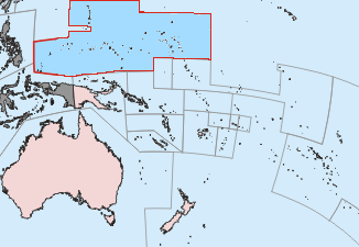
English: This is a locator map of the former Trust Territory of the Pacific Islands (TTPI).
Mənbə The map is based off of a locator map of Palau found on the German Wiki at de:Bild:Palau-Pos.png; it was created by German Wiki user de:Benutzer:Tzzzpfffand licensed under the GFDL. The changes made from the original map are various. The current boundries of the CNMI, Palau, FSM, and RMI are merged and Guam has it's own boundary due to the fact it never was a part of the TTPI. Boundries have been compared with Image:MapofTTPI.gif for accuracy. As the orginial image was licensed under the GFDL, I place my modification of the orginial map under the GFDL as well.
Müəllif
Atlas This map has been uploaded by Electionworld from en.wikipedia.org to enable the Wikimedia Atlas of the World . Original uploader to en.wikipedia.org was Hoshie, known as Hoshie at en.wikipedia.org. Electionworld is not the creator of this map. Licensing information is below.
İcazə
(Faylın təkrar istifadəsi)
GNU head Bu sənədi GNU Azad Sənədləşdirmə Lisenziyası, Versiya 1.2 və ya Azad Proqram Fondu tərəfindən nəşr olunan hər hansı sonrakı versiya şərtlərinə əsasən dəyişməz bölmələr, ön qapaq mətnləri və arxa qapaq mətnləri olmadan köçürmək, yayımlamaq və / və ya dəyişdirmək üçün icazə verilir; Lisenziyanın bir nüsxəsi GNU Azad Sənədləşdirmə Lisenziyası adlı hissəyə daxil edilmişdir.http://www.gnu.org/copyleft/fdl.htmlGFDLGNU Free Documentation Licensetruetrue
w:az:Creative Commons
istinad vermək bənzər paylaşma
Bu fayl Creative Commons Attribution-Share Alike 3.0 Unported lisenziyası altında yayımlanır.
Siz heç bir məhdudiyyət olmadan:
  • paylaşa bilərsiniz – əsəri köçürə, paylaya və ötürə bilərsiniz
  • remiks edə bilərsiniz – əsəri adaptasiya edə bilərsiniz
Aşağıdakı şərtlərə əməl etməklə:
  • istinad vermək – Müvafiq istinad verməli, lisenziyaya keçid əlavə etməli və dəyişikliklər edilib-edilmədiyini bildirməlisiniz . Siz bunu istənilən şəkildə edə bilərsiniz, lakin lisenziya verənin sizə şəxsən icazə verdiyini göstərən formada yox.
  • bənzər paylaşma – Əsəri remix edirsinizsə, dəyişdirirsinizsə və ya üzərində iş aparırsınızsa, öz töhfələrinizi orijinalda olduğu kimi eyni və ya uyğun lisenziya altında yayımlamalısınız.
This licensing tag was added to this file as part of the GFDL licensing update.http://creativecommons.org/licenses/by-sa/3.0/CC BY-SA 3.0Creative Commons Attribution-Share Alike 3.0truetrue

Başlıqlar

Bu faylın nəyi təmsil etdiyinə dair bir sətirlik izahat əlavə et
Trust Territory of the Pacific Islands among the Pacific Ocean
ပစိဖိတ်သမုဒ္ဒရာအတွင်းရှိ ပစိဖိတ်ကျွန်းစုများ အစောင့်အရှောက်ခံဒေသ

Bu faylda təsvir olunan elementlər

təsvir edir

Sakit Okean Adaları Qəyyum Ərazisi

copyright status ingilis

copyrighted ingilis

lisenziya

CC BY-SA 3.0

GNU Free Documentation License, version 1.2 or later ingilis

data size ingilis

11.229 Bayt

hündürlüyü/boyu

225 piksel

eni

326 piksel

media type ingilis

image/png

checksum ingilis

62078541f1a02ad3ce3da5c975106301e9462e22

təyinetmə üsulu: SHA-1

Faylın tarixçəsi

Faylın əvvəlki versiyasını görmək üçün gün/tarix bölməsindəki tarixlərə klikləyin.

Tarix/VaxtMiniatürÖlçülərİstifadəçiŞərh
hal-hazırkı01:27, 17 iyun 201001:27, 17 iyun 2010 tarixindəki versiyanın miniatür görüntüsü326 × 225 (11 KB)Ras67cropped
14:52, 19 noyabr 200614:52, 19 noyabr 2006 tarixindəki versiyanın miniatür görüntüsü330 × 228 (14 KB)Electionworld== Summary == This is a locator map of the former Trust Territory of the Pacific Islands (TTPI). The map is based off of a locator map of Palau found on the German Wiki at de:Bild:Palau-Pos.png; it was created by German Wiki user [[:de:Benutzer:T

Faylın istifadəsi

Aşağıdakı 2 səhifə bu faylı istifadə edir:

  • Cənubi Sakit okean mandatı
  • Sakit Okean Adaları Qəyyum Ərazisi

Faylın qlobal istifadəsi

Bu fayl aşağıdakı vikilərdə istifadə olunur:

  • ar.wikipedia.org layihəsində istifadəsi
    • تداعيات ما بعد الحرب العالمية الثانية
  • ast.wikipedia.org layihəsində istifadəsi
    • Territoriu en Fideicomisu de les Islles del Pacíficu
  • azb.wikipedia.org layihəsində istifadəsi
    • پاسیفیک آدالاری گوون بؤلگه سی
  • be.wikipedia.org layihəsində istifadəsi
    • Паўднёвы Ціхаакіянскі мандат
  • bg.wikipedia.org layihəsində istifadəsi
    • Подопечна територия на Тихоокеанските острови
  • ca.wikipedia.org layihəsində istifadəsi
    • Resolució 683 del Consell de Seguretat de les Nacions Unides
    • Resolució 21 del Consell de Seguretat de les Nacions Unides
    • Territori en Fideïcomís de les Illes del Pacífic
  • cs.wikipedia.org layihəsində istifadəsi
    • Poručenské území Tichomořské ostrovy
    • Mandátní území Tichomořské ostrovy
  • da.wikipedia.org layihəsində istifadəsi
    • Det japanske Stillehavsmandat
  • de.wikipedia.org layihəsində istifadəsi
    • Treuhandgebiet Pazifische Inseln
    • High Commissioner of the Trust Territory of the Pacific Islands
  • en.wikipedia.org layihəsində istifadəsi
    • Trust Territory of the Pacific Islands
    • Decolonization
    • Japan–Oceania relations
    • List of national border changes (1914–present)
    • Aftermath of World War II
    • High Commissioner of the Trust Territory of the Pacific Islands
    • Wikipedia:Graphics Lab/Map workshop/Archive/Oct 2010
    • Wikipedia:Reference desk/Archives/Humanities/2020 June 23
    • User:Falcaorib/Canada, United States and Mexico
  • eo.wikipedia.org layihəsində istifadəsi
    • Kuratora Teritorio Pacifikaj Insuloj
  • es.wikipedia.org layihəsində istifadəsi
    • Territorio en Fideicomiso de las Islas del Pacífico
    • Mandato del Pacífico Sur
  • fa.wikipedia.org layihəsində istifadəsi
    • قلمرو تحت قیمومت جزایر اقیانوس آرام
  • fi.wikipedia.org layihəsində istifadəsi
    • Tyynenmeren saarten huoltohallintoalue
  • fr.wikipedia.org layihəsində istifadəsi
    • États fédérés de Micronésie
    • Territoire sous tutelle des îles du Pacifique
    • Mandat des îles du Pacifique
    • Histoire des Palaos
    • Histoire des États fédérés de Micronésie
    • Constitution des États fédérés de Micronésie
  • he.wikipedia.org layihəsində istifadəsi
    • טריטוריית הנאמנות של איי האוקיינוס השקט
    • החלטה 21 של מועצת הביטחון של האו"ם
  • hu.wikipedia.org layihəsində istifadəsi
    • Csendes-óceáni-szigetek Gyámsági Terület
  • hy.wikipedia.org layihəsində istifadəsi
    • Երկրորդ համաշխարհային պատերազմի հետևանքներ
  • ia.wikipedia.org layihəsində istifadəsi
    • Appendice:Lista de codices telephonic international per pais
    • Appendice:Lista de objectos con proprietate ISO 3166-1 alpha-3
  • id.wikipedia.org layihəsində istifadəsi
    • Wilayah Perwalian Kepulauan Pasifik
  • it.wikipedia.org layihəsində istifadəsi
    • Territorio fiduciario delle Isole del Pacifico
    • Colonialismo statunitense
    • Mandato del Pacifico meridionale
  • ja.wikipedia.org layihəsində istifadəsi
    • 利用者:Nazki rhetorica/sandbox
  • ko.wikipedia.org layihəsində istifadəsi
    • 틀:태평양 제도 신탁통치령 표
    • 태평양 제도 신탁통치령
  • lt.wikipedia.org layihəsində istifadəsi
    • Pietų Ramiojo Vandenyno Mandatas
    • Ramiojo vandenyno salų globojamoji teritorija
  • mr.wikipedia.org layihəsində istifadəsi
    • मार्शल द्वीपसमूह
  • nl.wikipedia.org layihəsində istifadəsi
    • Lijst van vlaggen van Amerikaanse deelgebieden

Bu faylın qlobal istifadəsinə baxın.

Mənbə — "https://az.wikipedia.org/wiki/Fayl:TTPI-locatormap.png"
Informasiya Melumat Axtar