Butun axtardiqlarinizi tapmaq ucun buraya: DAXIL OLUN
  Mp4 Mp3 Axtar Yukle
  Video Axtar Yukle
  Shekil Axtar Yukle
  Informasiya Melumat Axtar
  Hazir Inshalar Toplusu
  AZERI CHAT + Tanishliq
  1-11 Sinif Derslikler Yukle
  Saglamliq Tibbi Melumat
  Whatsapp Plus Yukle(Yeni)

  • Ana səhifə
  • Təsadüfi
  • Yaxınlıqdakılar
  • Daxil ol
  • Nizamlamalar
İndi ianə et Əgər Vikipediya sizin üçün faydalıdırsa, bu gün ianə edin.

Fayl:Strait of Gibraltar perspective.jpg

  • Fayl
  • Müzakirə
  • Lokal izah əlavə et
  • Fayl
  • Faylın tarixçəsi
  • Faylın istifadəsi
  • Faylın qlobal istifadəsi
  • Metaməlumatlar
Fayl:Strait of Gibraltar perspective.jpg
Sınaq göstərişi ölçüsü: 800 × 480 piksel. Digər ölçülər: 320 × 192 piksel | 1.024 × 615 piksel | 1.528 × 917 piksel.

Faylın orijinalı (1.528 × 917 piksel, fayl həcmi: 182 KB, MIME növü: image/jpeg)

Bu fayl Vikianbarda yerləşir. Açıqlama səhifəsindəki məlumatlar aşağıda göstərilib.
Vikianbar azad lisenziyalı media anbarıdır. Siz də töhfə verə bilərsiniz.

Xülasə

İzahStrait of Gibraltar perspective.jpg
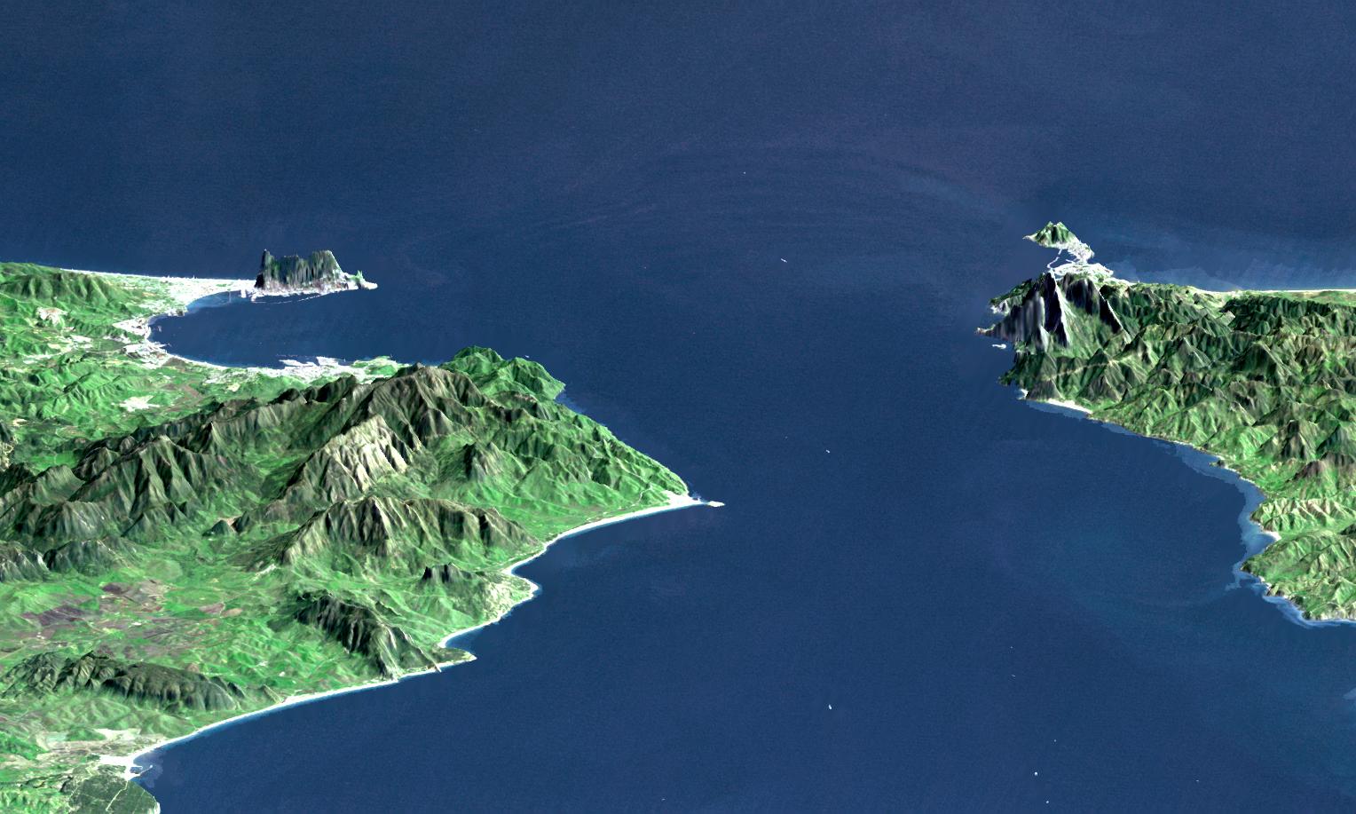
English: "This perspective view shows the Strait of Gibraltar, which is the entrance to the Mediterranean Sea from the Atlantic Ocean, with a 3-times vertical exaggeration to enhance topographic expression. Europe (Spain) is on the left. Africa (Morocco) is on the right. The Rock of Gibraltar, administered by Great Britain, is the peninsula in the back left." (quotation taken from the more detailed NASA description page)
  • View Size: 46 kilometers (28 miles) wide, 106 kilometers (66 miles) distance
  • Location: 36 degrees North latitude, 5.5 degrees West longitude
  • Orientation: Looking East, 15 degrees down from horizontal, 3X vertical exaggeration
  • Image Data: Landsat Bands 1, 2+4, 3 as blue, green, red respectively
  • Original Data Resolution: 30 meters (99 feet)
Deutsch: Straße von Gibraltar; Aufnahme der NASA dreifach überhöht. Erstellt aus Daten von SRTM und Landsat
Français : Vue en perspective du détroit de Gibraltar ouvrant sur la mer Mediterranée avec le Maroc à droite et l'Espagne a gauche. coté espagnol on remarque le rocher de Gibraltar, en face le petit rocher est Ceuta, territoire espagnol en terre africaine.
Español: Peñón de Gibraltar
Tarix
  • 24 oktyabr 2003, this image composite created using:
    • 11 fevral 2000 (SRTM)
    • 6 iyul 1987 (Landsat)
Mənbə http://photojournal.jpl.nasa.gov/catalog/PIA03397
Müəllif NASA / JPL / NIMA
Digər versiyalar

Derivative works of this file:

  • Strait of Gibraltar perspective-fr.svg
  • Strait of Gibraltar perspective-it.svg

Lisenziya

Public domainPublic domainfalsefalse
Public domain This file is in the public domain in the United States because it was solely created by NASA. NASA copyright policy states that "NASA material is not protected by copyright unless noted". (See Template:PD-USGov, NASA copyright policy page or JPL Image Use Policy.)
Warnings:
  • Use of NASA logos, insignia and emblems is restricted per U.S. law 14 CFR 1221.
  • The NASA website hosts a large number of images from the Soviet/Russian space agency, and other non-American space agencies. These are not necessarily in the public domain.
  • Materials based on Hubble Space Telescope data may be copyrighted if they are not explicitly produced by the STScI.[1] See also {{PD-Hubble}} and {{Cc-Hubble}}.
  • The SOHO (ESA & NASA) joint project implies that all materials created by its probe are copyrighted and require permission for commercial non-educational use. [2]
  • Images featured on the Astronomy Picture of the Day (APOD) web site may be copyrighted. [3]
  • The National Space Science Data Center (NSSDC) site has been known to host copyrighted content. Its photo gallery FAQ states that all of the images in the photo gallery are in the public domain "Unless otherwise noted."
Annotations
InfoField
This image is annotated: View the annotations at Commons
260
254
185
101
1528
917

Gibraltar

1091
222
197
122
1528
917

Ceuta

290
367
166
80
1528
917

Algeciras

726
522
74
61
1528
917

Tarifa

1387
527
73
59
1528
917

Kasr el Segir

1110
376
34
27
1528
917

Perejil

Başlıqlar

Bu faylın nəyi təmsil etdiyinə dair bir sətirlik izahat əlavə et

Bu faylda təsvir olunan elementlər

təsvir edir

Cəbəllütariq boğazı

copyright status ingilis

ictimai mülkiyyət

yurisdiksiyasındadır: Amerika Birləşmiş Ştatları
təyinetmə üsulu: work of the federal government of the United States ingilis

yaranma tarixi

24 oktyabr 2003

Faylın tarixçəsi

Faylın əvvəlki versiyasını görmək üçün gün/tarix bölməsindəki tarixlərə klikləyin.

Tarix/VaxtMiniatürÖlçülərİstifadəçiŞərh
hal-hazırkı00:20, 14 noyabr 200500:20, 14 noyabr 2005 tarixindəki versiyanın miniatür görüntüsü1.528 × 917 (182 KB)Oxam Hartogen : Perspective view from the Strait of Gibraltar, Marocco is on rigth, Spain on left with the Rock of Gibraltar ahead on left. On the other side the little rock is Ceuta Spain territory on african continent fr: Vue en perspective du detroit de Gibaltar

Faylın istifadəsi

Aşağıdakı səhifə bu faylı istifadə edir:

  • Mərakeş burnu

Faylın qlobal istifadəsi

Bu fayl aşağıdakı vikilərdə istifadə olunur:

  • af.wikipedia.org layihəsində istifadəsi
    • Straat van Gibraltar
  • ar.wikipedia.org layihəsində istifadəsi
    • طارق بن زياد
    • تاريخ الريف (شمال المغرب)
  • azb.wikipedia.org layihəsində istifadəsi
    • بوغاز
  • bar.wikipedia.org layihəsində istifadəsi
    • 709
    • Ceuta
  • be.wikipedia.org layihəsində istifadəsi
    • Марокі
  • bo.wikipedia.org layihəsində istifadəsi
    • མཚོ་འགག
  • br.wikipedia.org layihəsində istifadəsi
    • Strizh-mor Jibraltar
  • bs.wikipedia.org layihəsində istifadəsi
    • Ceuta
  • ca.wikipedia.org layihəsində istifadəsi
    • Estret
  • ckb.wikipedia.org layihəsində istifadəsi
    • ئەندەلوس
  • de.wikipedia.org layihəsində istifadəsi
    • 709
    • Ceuta
    • Entdeckung Amerikas
    • Punta de Tarifa
    • Diskussion:Straße von Gibraltar
    • Straße von Gibraltar
    • Gibraltartunnel
  • de.wiktionary.org layihəsində istifadəsi
    • Gibraltar
  • en.wikipedia.org layihəsində istifadəsi
    • Ceuta
    • Strait of Gibraltar crossing
    • Wikipedia:GLAM/GibraltarpediA/Images/Geography
  • en.wikivoyage.org layihəsində istifadəsi
    • Gibraltar
  • es.wikipedia.org layihəsində istifadəsi
    • Portal:Andalucía/Imagen
    • Portal:Andalucía/Imagen/19
    • Límites de Andalucía
  • et.wikipedia.org layihəsində istifadəsi
    • Marroquí neem
  • frr.wikipedia.org layihəsində istifadəsi
    • Struat faan Gibraltaar
  • fr.wikipedia.org layihəsində istifadəsi
    • Droit de la mer
    • Détroit
    • Wikipédia:Atelier graphique/Cartes/Archives/avril 2012
  • kbd.wikipedia.org layihəsində istifadəsi
    • Тарифэ
  • ky.wikipedia.org layihəsində istifadəsi
    • Кысык
  • lt.wikipedia.org layihəsində istifadəsi
    • Taikaus plaukimo teisė
  • nl.wikipedia.org layihəsində istifadəsi
    • Zuilen van Hercules
    • Straat van Gibraltar
  • pl.wikivoyage.org layihəsində istifadəsi
    • Gibraltar
  • pl.wiktionary.org layihəsində istifadəsi
    • Gibraltar
  • pt.wikipedia.org layihəsində istifadəsi
    • Estreito
  • ro.wikipedia.org layihəsində istifadəsi
    • Descoperirea Americilor
  • ru.wikipedia.org layihəsində istifadəsi
    • Марроки (мыс)
  • ru.wiktionary.org layihəsində istifadəsi
    • канал
  • si.wikipedia.org layihəsində istifadəsi
    • සියුටා
  • sl.wikipedia.org layihəsində istifadəsi
    • Prečkanje Gibraltarske ožine
  • sw.wikipedia.org layihəsində istifadəsi
    • Mlango wa Gibraltar
  • te.wikipedia.org layihəsində istifadəsi
    • సియుటా
  • uk.wikipedia.org layihəsində istifadəsi
    • Морське право
  • uz.wikipedia.org layihəsində istifadəsi
    • Gibraltar boʻgʻozi
    • Gibraltar boʻgʻozi kesishmasi

Bu faylın qlobal istifadəsinə baxın.

Metaməlumatlar

Bu faylda fotoaparat və ya skanerlə əlavə olunmuş məlumatlar var. Əgər fayl sonradan olunubsa, bəzi parametrlər bu şəkildə göstərilənlərdən fərqli ola bilər.

JPEG şəkil şərhiuploaded on 2005-11-14

source : http://photojournal.jpl.nasa.gov/jpegMod/PIA03397_modest.jpg

Strait of Gibraltar, Perspective with Landsat Image

Elevation data used in this image was acquired by the Shuttle Radar Topography Mission (SRTM) aboard the Space Shuttle Endeavour, launched on February 11, 2000

Credit : NASA/JPL/NIMA

Public domain
Mənbə — "https://az.wikipedia.org/wiki/Fayl:Strait_of_Gibraltar_perspective.jpg"
Informasiya Melumat Axtar