Bu fayl Vikianbarda yerləşir. Açıqlama səhifəsindəki məlumatlar aşağıda göstərilib. Vikianbar azad lisenziyalı media anbarıdır. Siz də töhfə verə bilərsiniz. |
This locator map image could be re-created using vector graphics as an SVG file. This has several advantages; see Commons:Media for cleanup for more information. If an SVG form of this image is available, please upload it and afterwards replace this template with
{{vector version available|new image name}}.It is recommended to name the SVG file “Spratly with flags.svg”—then the template Vector version available (or Vva) does not need the new image name parameter. |
| İzah |
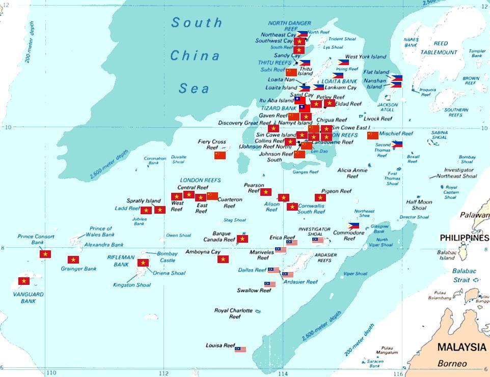
Spratly islands map showing occupied features marked with the flags of countries occupying them.
Kennan Reef (C) The flag nearest the flag for Johnson South Reef (C). |
||||||
| Tarix | (Original Picture), February 3, 2008 (Modified Picture) | ||||||
| Mənbə | Central Intelligence Agency. | ||||||
| Müəllif | CIA. Cropped and Flags added by Estarapapax. | ||||||
| İcazə (Faylın təkrar istifadəsi) |
|
||||||
Faylın tarixçəsi
Faylın əvvəlki versiyasını görmək üçün gün/tarix bölməsindəki tarixlərə klikləyin.
| Tarix/Vaxt | Miniatür | Ölçülər | İstifadəçi | Şərh | |
|---|---|---|---|---|---|
| hal-hazırkı | 05:38, 25 mart 2008 | | 962 × 741 (94 KB) | KAVO | {{Information |Description=Spratly islands map showing occupied features marked with the flags of countries occupying them. <br>{{flagicon|Philippines}} Philippines <br>{{flagicon|Taiwan}} Taiwan <br>{{flagicon|Vietnam}} Vietnam <br>{{flagicon|Malaysia}} |
Faylın istifadəsi
Aşağıdakı səhifə bu faylı istifadə edir:
Faylın qlobal istifadəsi
Bu fayl aşağıdakı vikilərdə istifadə olunur:
- bg.wikipedia.org layihəsində istifadəsi
- ceb.wikipedia.org layihəsində istifadəsi
- cs.wikipedia.org layihəsində istifadəsi
- da.wikipedia.org layihəsində istifadəsi
- de.wikipedia.org layihəsində istifadəsi
- en.wikipedia.org layihəsində istifadəsi
- es.wikipedia.org layihəsində istifadəsi
- et.wikipedia.org layihəsində istifadəsi
- eu.wikipedia.org layihəsində istifadəsi
- fr.wikipedia.org layihəsində istifadəsi
- gl.wikipedia.org layihəsində istifadəsi
- hi.wikipedia.org layihəsində istifadəsi
- id.wikipedia.org layihəsində istifadəsi
- ja.wikipedia.org layihəsində istifadəsi
Bu faylın qlobal istifadəsinə baxın.