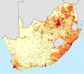
Bu SVG-faylın PNG formatındakı bu görünüşünün ölçüsü: 684 × 599 piksel. Digər ölçülər: 274 × 240 piksel | 548 × 480 piksel | 876 × 768 piksel | 1.168 × 1.024 piksel | 2.337 × 2.048 piksel | 809 × 709 piksel.
Faylın orijinalı (SVG faylı, nominal olaraq 809 × 709 piksel, faylın ölçüsü: 1,93 MB)
Faylın tarixçəsi
Faylın əvvəlki versiyasını görmək üçün gün/tarix bölməsindəki tarixlərə klikləyin.
| Tarix/Vaxt | Miniatür | Ölçülər | İstifadəçi | Şərh | |
|---|---|---|---|---|---|
| hal-hazırkı | 23:36, 14 noyabr 2012 |  | 809 × 709 (1,93 MB) | Htonl | fix KZN coast error |
| 21:57, 14 noyabr 2012 |  | 809 × 709 (1,93 MB) | Htonl | == {{int:filedesc}} == {{Information |Description={{en|1=Population density map of South Africa, based on the 2011 census using ward-level data. {{legend|#ffffcc|<1 inhabitant/km²}} {{legend|#ffeda0|1–3 inhabitants/km²}} {{legend|#fed976|3–10 ... |
Faylın istifadəsi
Aşağıdakı səhifə bu faylı istifadə edir:
Faylın qlobal istifadəsi
Bu fayl aşağıdakı vikilərdə istifadə olunur:
- af.wikipedia.org layihəsində istifadəsi
- azb.wikipedia.org layihəsində istifadəsi
- ca.wikipedia.org layihəsində istifadəsi
- cs.wikipedia.org layihəsində istifadəsi
- de.wikipedia.org layihəsində istifadəsi
- el.wikipedia.org layihəsində istifadəsi
- en.wikipedia.org layihəsində istifadəsi
- es.wikipedia.org layihəsində istifadəsi
- et.wikipedia.org layihəsində istifadəsi
- fr.wikipedia.org layihəsində istifadəsi
- gl.wikipedia.org layihəsində istifadəsi
- he.wikipedia.org layihəsində istifadəsi
- hu.wikipedia.org layihəsində istifadəsi
- hy.wikipedia.org layihəsində istifadəsi
- ja.wikipedia.org layihəsində istifadəsi
- ka.wikipedia.org layihəsində istifadəsi
- ko.wikipedia.org layihəsində istifadəsi
- la.wikipedia.org layihəsində istifadəsi
- lt.wikipedia.org layihəsində istifadəsi
- ml.wikipedia.org layihəsində istifadəsi
- nl.wikipedia.org layihəsində istifadəsi
- no.wikipedia.org layihəsində istifadəsi
- pt.wikipedia.org layihəsində istifadəsi
- ro.wikipedia.org layihəsində istifadəsi
- ru.wikipedia.org layihəsində istifadəsi
- sr.wikipedia.org layihəsində istifadəsi
- sv.wikipedia.org layihəsində istifadəsi
- te.wikipedia.org layihəsində istifadəsi
- tg.wikipedia.org layihəsində istifadəsi
- tr.wikipedia.org layihəsində istifadəsi
- uk.wikipedia.org layihəsində istifadəsi
- zh.wikipedia.org layihəsində istifadəsi
- zu.wikipedia.org layihəsində istifadəsi

