Sınaq göstərişi ölçüsü: 800 × 578 piksel. Digər ölçülər: 320 × 231 piksel | 640 × 462 piksel | 863 × 623 piksel.
Faylın orijinalı (863 × 623 piksel, fayl həcmi: 62 KB, MIME növü: image/png)
Bu fayl Vikianbarda yerləşir. Açıqlama səhifəsindəki məlumatlar aşağıda göstərilib. Vikianbar azad lisenziyalı media anbarıdır. Siz də töhfə verə bilərsiniz. |
This map image could be re-created using vector graphics as an SVG file. This has several advantages; see Commons:Media for cleanup for more information. If an SVG form of this image is available, please upload it and afterwards replace this template with
{{vector version available|new image name}}.It is recommended to name the SVG file “Serbia1817.svg”—then the template Vector version available (or Vva) does not need the new image name parameter. |
Xülasə
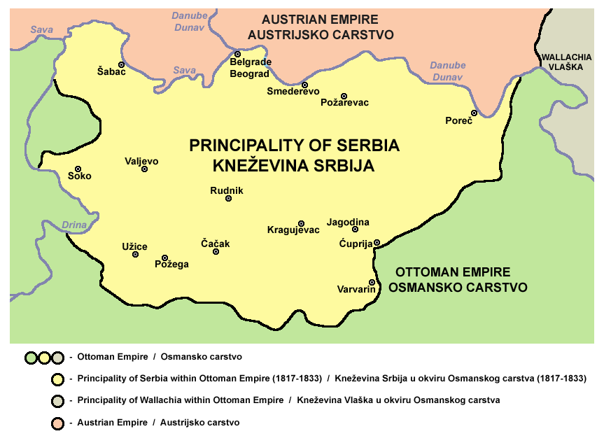
- Principality of Serbia in 1817.
- Kneževina Srbija 1817. godine.
Source and license

|
This map has been uploaded by Electionworld from en.wikipedia.org to enable the |
Self-made map by PANONIAN
| This work has been released into the public domain by its author, PANONIAN. This applies worldwide. In some countries this may not be legally possible; if so: |
References
- Školski istorijski atlas, Zavod za izdavanje udžbenika SR Srbije, Beograd, 1970.
- Povijesni atlas, Učila - Zagreb, Zagreb, 1971.
- Dr Tomislav Bogavac, Nestajanje Srba, Niš, 1994.
- Istorijski atlas, Intersistem Kartografija, Beograd, 2010.
- Istorijski atlas, Geokarta, Beograd, 1999.
- Sima M. Ćirković, Srbi među evropskim narodima, Beograd, 2004.
- Sve srpske mape - od šestog veka do Pariza, Specijalno izdanje BLICA, Decembar 1995. godine.
- The Times History of Europe, Times Books, London, 2002.
- http://terkepek.adatbank.transindex.ro/kepek/netre/99.gif archive copy at the Wayback Machine
- http://www.znanje.org/i/i21/01iv04/01iv0418/images/knezevina_srbija_1.jpg
- http://www.znanje.org/i/i21/01iv04/01iv0418/images/knezevina_srbija_3.jpg
- http://www.zum.de/whkmla/histatlas/balkans/Serbia%201813%20to%201918.gif
derivative works
Faylın tarixçəsi
Faylın əvvəlki versiyasını görmək üçün gün/tarix bölməsindəki tarixlərə klikləyin.
| Tarix/Vaxt | Miniatür | Ölçülər | İstifadəçi | Şərh | |
|---|---|---|---|---|---|
| hal-hazırkı | 22:06, 14 oktyabr 2012 | | 863 × 623 (62 KB) | WikiEditor2004 | {{Information |Description ={{en|1=improved my own work}} |Source =improved my own work |Author =improved my own work |Date = |Permission = |other_versions = }} |
| 21:39, 21 dekabr 2006 |  | 597 × 460 (11 KB) | Electionworld | {{ew|en|PANONIAN}} Self-made map by PANONIAN {{PD-user|PANONIAN}} Category:Maps of Serbia |
Faylın istifadəsi
Aşağıdakı səhifə bu faylı istifadə edir:
Faylın qlobal istifadəsi
Bu fayl aşağıdakı vikilərdə istifadə olunur:
- ar.wikipedia.org layihəsində istifadəsi
- ba.wikipedia.org layihəsində istifadəsi
- be-tarask.wikipedia.org layihəsində istifadəsi
- be.wikipedia.org layihəsində istifadəsi
- bg.wikipedia.org layihəsində istifadəsi
- ca.wikipedia.org layihəsində istifadəsi
- ckb.wikipedia.org layihəsində istifadəsi
- cs.wikipedia.org layihəsində istifadəsi
- de.wikipedia.org layihəsində istifadəsi
- el.wikipedia.org layihəsində istifadəsi
- en.wikipedia.org layihəsində istifadəsi
- et.wikipedia.org layihəsində istifadəsi
- fr.wikipedia.org layihəsində istifadəsi
- gl.wikipedia.org layihəsində istifadəsi
- he.wikipedia.org layihəsində istifadəsi
- hr.wikipedia.org layihəsində istifadəsi
- hu.wikipedia.org layihəsində istifadəsi
- hy.wikipedia.org layihəsində istifadəsi
- id.wikipedia.org layihəsində istifadəsi
- it.wikipedia.org layihəsində istifadəsi
- ja.wikipedia.org layihəsində istifadəsi
- ka.wikipedia.org layihəsində istifadəsi
- lv.wikipedia.org layihəsində istifadəsi
- mk.wikipedia.org layihəsində istifadəsi
- nl.wikipedia.org layihəsində istifadəsi
- pl.wikipedia.org layihəsində istifadəsi
Bu faylın qlobal istifadəsinə baxın.