Butun axtardiqlarinizi tapmaq ucun buraya: DAXIL OLUN
  Mp4 Mp3 Axtar Yukle
  Video Axtar Yukle
  Shekil Axtar Yukle
  Informasiya Melumat Axtar
  Hazir Inshalar Toplusu
  AZERI CHAT + Tanishliq
  1-11 Sinif Derslikler Yukle
  Saglamliq Tibbi Melumat
  Whatsapp Plus Yukle(Yeni)

  • Ana səhifə
  • Təsadüfi
  • Yaxınlıqdakılar
  • Daxil ol
  • Nizamlamalar
İndi ianə et Əgər Vikipediya sizin üçün faydalıdırsa, bu gün ianə edin.

Fayl:Satellite Lanzarote Chinijo.jpg

  • Fayl
  • Müzakirə
  • Lokal izah əlavə et
  • Fayl
  • Faylın tarixçəsi
  • Faylın istifadəsi
  • Faylın qlobal istifadəsi
  • Metaməlumatlar
Fayl:Satellite Lanzarote Chinijo.jpg
Daha yüksək versiyası yoxdur.

Satellite_Lanzarote_Chinijo.jpg (422 × 253 piksel, fayl həcmi: 30 KB, MIME növü: image/jpeg)

Bu fayl Vikianbarda yerləşir. Açıqlama səhifəsindəki məlumatlar aşağıda göstərilib.
Vikianbar azad lisenziyalı media anbarıdır. Siz də töhfə verə bilərsiniz.

Xülasə

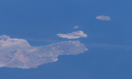
Español: De abajo a arriba, Lanzarote, La Graciosa, Montaña Clara y Alegranza

Satellite photo showing Lanzarote and Chinijo Archipielago. From bottom to top, Lanzarote, La Graciosa, Montaña Clara y Alegranza.

Public domainPublic domainfalsefalse
Public domain This file is in the public domain in the United States because it was solely created by NASA. NASA copyright policy states that "NASA material is not protected by copyright unless noted". (See Template:PD-USGov, NASA copyright policy page or JPL Image Use Policy.)
Warnings:
  • Use of NASA logos, insignia and emblems is restricted per U.S. law 14 CFR 1221.
  • The NASA website hosts a large number of images from the Soviet/Russian space agency, and other non-American space agencies. These are not necessarily in the public domain.
  • Materials based on Hubble Space Telescope data may be copyrighted if they are not explicitly produced by the STScI.[1] See also {{PD-Hubble}} and {{Cc-Hubble}}.
  • The SOHO (ESA & NASA) joint project implies that all materials created by its probe are copyrighted and require permission for commercial non-educational use. [2]
  • Images featured on the Astronomy Picture of the Day (APOD) web site may be copyrighted. [3]
  • The National Space Science Data Center (NSSDC) site has been known to host copyrighted content. Its photo gallery FAQ states that all of the images in the photo gallery are in the public domain "Unless otherwise noted."

Source

  • http://eol.jsc.nasa.gov/

Image courtesy of the Image Analysis Laboratory, NASA Johnson Space Center.

Başlıqlar

Bu faylın nəyi təmsil etdiyinə dair bir sətirlik izahat əlavə et

Bu faylda təsvir olunan elementlər

təsvir edir

copyright status ingilis

ictimai mülkiyyət

yurisdiksiyasındadır: Amerika Birləşmiş Ştatları
təyinetmə üsulu: work of the federal government of the United States ingilis

Faylın tarixçəsi

Faylın əvvəlki versiyasını görmək üçün gün/tarix bölməsindəki tarixlərə klikləyin.

Tarix/VaxtMiniatürÖlçülərİstifadəçiŞərh
hal-hazırkı07:05, 25 iyun 200507:05, 25 iyun 2005 tarixindəki versiyanın miniatür görüntüsü422 × 253 (30 KB)PoraoImagen de satélite de Lanzarote y el Archipiélago Chinijo. De abajo a arriba, Lanzarote, La Graciosa, Montaña Clara y Alegranza.

Faylın istifadəsi

Aşağıdakı səhifə bu faylı istifadə edir:

  • Lançelotto Maloçello

Faylın qlobal istifadəsi

Bu fayl aşağıdakı vikilərdə istifadə olunur:

  • de.wikipedia.org layihəsində istifadəsi
    • Chinijo-Archipel
    • Liste der UNESCO Global Geoparks in Afrika
  • en.wikipedia.org layihəsində istifadəsi
    • Chinijo Archipelago
    • Lancelotto Malocello
    • List of Sites of Community Importance in the Canary Islands
  • eo.wikipedia.org layihəsində istifadəsi
    • Lanzarote
    • Ĉiniĥa Insularo
  • es.wikipedia.org layihəsində istifadəsi
    • Reservas marinas de Canarias
    • Anexo:Zonas especiales de conservación de las Islas Canarias
  • fa.wikipedia.org layihəsində istifadəsi
    • لانزاروته
    • لانچلوتو مالوچلو
  • fr.wikipedia.org layihəsində istifadəsi
    • Archipel de Chinijo
    • Utilisateur:Skiff/A illustrer
  • gl.wikipedia.org layihəsində istifadəsi
    • Arquipélago Chinijo
  • id.wikipedia.org layihəsində istifadəsi
    • Kepulauan Chinijo
    • Lancelotto Malocello
  • it.wikipedia.org layihəsində istifadəsi
    • Arcipelago Chinijo
    • Utente:LçMaroxello
    • Discussioni utente:LçMaroxello
  • lij.wikipedia.org layihəsində istifadəsi
    • Utente:LMalocello
    • Discûscioîn ûtente:LMalocello
    • Utente:LçMaroxello
    • Discûscioîn ûtente:LçMaroxello
  • nl.wikipedia.org layihəsində istifadəsi
    • Chinijo
  • nn.wikipedia.org layihəsində istifadəsi
    • Chinijoøyane
  • no.wikipedia.org layihəsində istifadəsi
    • Alegranza
    • Roque del Este
    • Roque del Oeste
    • Chinijoøyene
  • pl.wikipedia.org layihəsində istifadəsi
    • Archipelag Chinijo
    • Światowa Sieć Geoparków
  • pt.wikipedia.org layihəsində istifadəsi
    • Arquipélago Chinijo
  • ru.wikipedia.org layihəsində istifadəsi
    • Малочелло, Ланцеротто
    • Чинихо
  • sk.wikipedia.org layihəsində istifadəsi
    • Kanárske ostrovy
  • sv.wikipedia.org layihəsində istifadəsi
    • Lanzarote
    • Chinijoarkipelagen
  • uk.wikipedia.org layihəsində istifadəsi
    • Ланцеротто Малочелло
  • www.wikidata.org layihəsində istifadəsi
    • User:LMalocello
    • User talk:LMalocello
    • User:LçMaroxello
    • User talk:LçMaroxello
  • zh.wikipedia.org layihəsində istifadəsi
    • 奇尼霍群岛

Metaməlumatlar

Bu faylda fotoaparat və ya skanerlə əlavə olunmuş məlumatlar var. Əgər fayl sonradan olunubsa, bəzi parametrlər bu şəkildə göstərilənlərdən fərqli ola bilər.

OrientasiyaNormal
Üfüqi xətt72 dpi
Şaquli xətt72 dpi
Proqram təminatıAdobe Photoshop CS Windows
Faylın dəyişməsi tarixi və vaxtı09:02, 25 iyun 2005
Rəng sahəsisRGB
Mənbə — "https://az.wikipedia.org/wiki/Fayl:Satellite_Lanzarote_Chinijo.jpg"
Informasiya Melumat Axtar