Butun axtardiqlarinizi tapmaq ucun buraya: DAXIL OLUN
  Mp4 Mp3 Axtar Yukle
  Video Axtar Yukle
  Shekil Axtar Yukle
  Informasiya Melumat Axtar
  Hazir Inshalar Toplusu
  AZERI CHAT + Tanishliq
  1-11 Sinif Derslikler Yukle
  Saglamliq Tibbi Melumat
  Whatsapp Plus Yukle(Yeni)

  • Ana səhifə
  • Təsadüfi
  • Yaxınlıqdakılar
  • Daxil ol
  • Nizamlamalar
İndi ianə et Əgər Vikipediya sizin üçün faydalıdırsa, bu gün ianə edin.

Fayl:Salvador Satellite.jpg

  • Fayl
  • Müzakirə
  • Lokal izah əlavə et
  • Fayl
  • Faylın tarixçəsi
  • Faylın istifadəsi
  • Faylın qlobal istifadəsi
Fayl:Salvador Satellite.jpg
Sınaq göstərişi ölçüsü: 600 × 600 piksel. Digər ölçülər: 240 × 240 piksel | 480 × 480 piksel | 768 × 768 piksel | 1.024 × 1.024 piksel | 2.048 × 2.048 piksel | 4.096 × 4.096 piksel.

Faylın orijinalı (4.096 × 4.096 piksel, fayl həcmi: 16,58 MB, MIME növü: image/jpeg)

Bu fayl Vikianbarda yerləşir. Açıqlama səhifəsindəki məlumatlar aşağıda göstərilib.
Vikianbar azad lisenziyalı media anbarıdır. Siz də töhfə verə bilərsiniz.

Xülasə

İzahSalvador Satellite.jpg
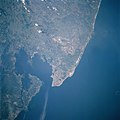
English: NM23-721-551 Salvador, All Saints Bay, Brazil Winter/Spring 1997
The first formally established settlement in Brazil, the city of Salvador, is located on the tip of the peninsula. All Saints Bay, an inlet of the Atlantic Ocean, provides a protected harbor to the city. Salvador is divided into an upper city, which is built along a cliff overlooking the bay, and a lower city, which extends from the foot of the cliff westward to the bay. The upper and lower cities are connected by elevators, cable cars, and graded roads. Salvador is the commercial center of the Reconcavo, a major agricultural area, and a major shipping center for the Cacao district to the south. Food processing is one of the leading industries in the city. Salvador is also a leading and fashionable tourist center. Because of an influx of black African slaves, the area is noted for its African heritage in music, dance, folk customs, and cuisine. The lighter tan-colored region to the north-northeast of Salvador is a major oil field.
Tarix 3 aprel 1997
Mənbə https://eol.jsc.nasa.gov/SearchPhotos/photo.pl?mission=NM23&roll=721&frame=551
Müəllif Image Science & Analysis Laboratory, NASA Johnson Space Center
Digər versiyalar
File:Salvador e Baía de Todos os Santos.jpg

Lisenziya

Public domainPublic domainfalsefalse
Public domain
This file is in the public domain in the United States because it was created by the Image Science & Analysis Laboratory, of the NASA Johnson Space Center. NASA copyright policy states that "NASA material is not protected by copyright unless noted". (NASA media use guidelines or Conditions of Use of Astronaut Photographs). Photo source: NM23-721-551.

العربيَّة | Deutsch | English | español | français | italiano | kurdî | македонски | മലയാളം | português | sicilianu | +/−

Başlıqlar

Bu faylın nəyi təmsil etdiyinə dair bir sətirlik izahat əlavə et

Bu faylda təsvir olunan elementlər

təsvir edir

copyright status ingilis

ictimai mülkiyyət

yurisdiksiyasındadır: Amerika Birləşmiş Ştatları
təyinetmə üsulu: work of the federal government of the United States ingilis

yaranma tarixi

3 aprel 1997

Faylın tarixçəsi

Faylın əvvəlki versiyasını görmək üçün gün/tarix bölməsindəki tarixlərə klikləyin.

Tarix/VaxtMiniatürÖlçülərİstifadəçiŞərh
hal-hazırkı17:56, 2 dekabr 201617:56, 2 dekabr 2016 tarixindəki versiyanın miniatür görüntüsü4.096 × 4.096 (16,58 MB)Ras67high resolution
05:19, 23 dekabr 200505:19, 23 dekabr 2005 tarixindəki versiyanın miniatür görüntüsü640 × 640 (313 KB)Kenta*~commonswikiNM23-721-551 Salvador, All Saints Bay, Brazil Winter/Spring 1997 The first formally established settlement in Brazil, the city of Salvador, is located on the tip of the peninsula. All Saints Bay, an inlet of the Atlantic Ocean, provides a protected harbo

Faylın istifadəsi

Aşağıdakı səhifə bu faylı istifadə edir:

  • Taduz-us-Santus körfəzi

Faylın qlobal istifadəsi

Bu fayl aşağıdakı vikilərdə istifadə olunur:

  • ca.wikipedia.org layihəsində istifadəsi
    • Badia de Todos os Santos
  • ceb.wikipedia.org layihəsində istifadəsi
    • Baía de Todos os Santos
  • de.wikipedia.org layihəsində istifadəsi
    • Allerheiligenbucht
    • Liste der größten Meeresbuchten in Brasilien
    • Wissenschaftsjahr 1501
  • en.wikipedia.org layihəsində istifadəsi
    • Bay of All Saints
  • eo.wikipedia.org layihəsində istifadəsi
    • Salvadoro de Bahio
  • es.wikipedia.org layihəsində istifadəsi
    • Bahía de Todos los Santos
  • he.wikipedia.org layihəsində istifadəsi
    • סלבדור (ברזיל)
  • hr.wikipedia.org layihəsində istifadəsi
    • Bahia
    • Salvador (Brazil)
  • it.wikipedia.org layihəsində istifadəsi
    • Baia di Ognissanti
  • ja.wikipedia.org layihəsində istifadəsi
    • サルヴァドール
  • nl.wikipedia.org layihəsində istifadəsi
    • Allerheiligenbaai
  • nn.wikipedia.org layihəsində istifadəsi
    • Salvador
  • no.wikipedia.org layihəsində istifadəsi
    • Salvador
  • pl.wikipedia.org layihəsində istifadəsi
    • Zatoka Wszystkich Świętych
  • pl.wiktionary.org layihəsində istifadəsi
    • Zatoka Wszystkich Świętych
  • pt.wikipedia.org layihəsində istifadəsi
    • Salvador
    • Região Metropolitana de Salvador
    • Baía de Todos-os-Santos
    • Lista de municípios da Bahia por área urbana
  • ru.wikipedia.org layihəsində istifadəsi
    • Тодуз-ус-Сантус
    • Захват Салвадор-да-Баия португальцами
  • sl.wikipedia.org layihəsində istifadəsi
    • Zaliv Vseh svetih, Salvador, Bahia
  • sr.wikipedia.org layihəsində istifadəsi
    • Салвадор (Бразил)
    • Залив Свих Светих
  • sv.wikipedia.org layihəsində istifadəsi
    • Salvador, Brasilien
  • tt.wikipedia.org layihəsində istifadəsi
    • Barlıq İzgelär buxtası
  • www.wikidata.org layihəsində istifadəsi
    • Q1310944
Mənbə — "https://az.wikipedia.org/wiki/Fayl:Salvador_Satellite.jpg"
Informasiya Melumat Axtar