Butun axtardiqlarinizi tapmaq ucun buraya: DAXIL OLUN
  Mp4 Mp3 Axtar Yukle
  Video Axtar Yukle
  Shekil Axtar Yukle
  Informasiya Melumat Axtar
  Hazir Inshalar Toplusu
  AZERI CHAT + Tanishliq
  1-11 Sinif Derslikler Yukle
  Saglamliq Tibbi Melumat
  Whatsapp Plus Yukle(Yeni)

  • Ana səhifə
  • Təsadüfi
  • Yaxınlıqdakılar
  • Daxil ol
  • Nizamlamalar
İndi ianə et Əgər Vikipediya sizin üçün faydalıdırsa, bu gün ianə edin.

Fayl:STS059-238-074 Strait of Gibraltar.jpg

  • Fayl
  • Müzakirə
  • Lokal izah əlavə et
  • Fayl
  • Faylın tarixçəsi
  • Faylın istifadəsi
  • Faylın qlobal istifadəsi
  • Metaməlumatlar
Fayl:STS059-238-074 Strait of Gibraltar.jpg
Sınaq göstərişi ölçüsü: 606 × 600 piksel. Digər ölçülər: 242 × 240 piksel | 485 × 480 piksel | 776 × 768 piksel | 1.034 × 1.024 piksel | 2.069 × 2.048 piksel | 5.275 × 5.222 piksel.

Faylın orijinalı (5.275 × 5.222 piksel, fayl həcmi: 13,27 MB, MIME növü: image/jpeg)

Bu fayl Vikianbarda yerləşir. Açıqlama səhifəsindəki məlumatlar aşağıda göstərilib.
Vikianbar azad lisenziyalı media anbarıdır. Siz də töhfə verə bilərsiniz.

Xülasə

İzahSTS059-238-074 Strait of Gibraltar.jpg
Español: Estrecho de Gibraltar y Mar de Alborán
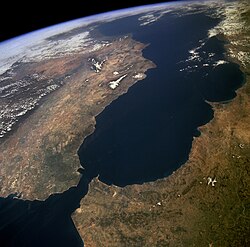
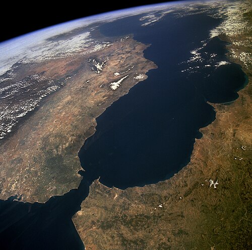
English: The Strait of Gibraltar provides a natural physical barrier between the countries of Spain (north) and Morocco (south). In geologic terms, the 10-mile (16-kilometer) strait that separates the two countries, as well as Europe and Africa, is located where the two major tectonic plates—the Eurasian Plate and the African Plate—collide. This high-oblique, northeast-looking photograph shows the mountainous northern coast of Morocco and the coastal mountains of southern Spain, including the dagger-shaped, snow-covered Sierra Nevada Mountains of southeastern Spain. The Guadalquivir River flows from east to west along the base of the Sierra Morena Mountains in southern Spain. The famous British city of Gibraltar is located on the wedge-shaped peninsula on the east side of the bay in the southernmost protrusion of Spain. The city of Ceuta is a Spanish enclave on the extreme northeastern coast of Morocco. Ceuta, a free port with a large harbor, has remained under Spanish control since 1580.
Norsk nynorsk: Satelittfoto frå NASA med Den iberiske halvøya til venstre (nord) og Maghreb til høgre (sør). Vi ser Middelhavet i bakgrunnen og Atlanterhavet nedst til venstre i forgrunnen. Innsnevringa mellom Atlanterhavet og Middelhavet er Gibraltarsundet.
Tarix 14 aprel 1994
Mənbə http://images.jsc.nasa.gov/luceneweb/caption_direct.jsp?photoId=STS059-238-074
https://www.flickr.com/photos/nasa2explore/9364207155/
Müəllif NASA
This image or video was catalogued by one of the centers of the United States National Aeronautics and Space Administration (NASA) under Photo ID: STS059-238-074.

This tag does not indicate the copyright status of the attached work. A normal copyright tag is still required. See Commons:Licensing.
Other languages:

Afrikaans ∙ العربية ∙ беларуская (тарашкевіца) ∙ български ∙ Bahaso Jambi ∙ català ∙ čeština ∙ dansk ∙ Deutsch ∙ English ∙ español ∙ فارسی ∙ français ∙ galego ∙ magyar ∙ հայերեն ∙ Bahasa Indonesia ∙ italiano ∙ 日本語 ∙ македонски ∙ മലയാളം ∙ Nederlands ∙ polski ∙ português ∙ русский ∙ sicilianu ∙ slovenščina ∙ Türkçe ∙ українська ∙ 简体中文 ∙ 繁體中文 ∙ +/−

Lisenziya

Public domainPublic domainfalsefalse
Public domain This file is in the public domain in the United States because it was solely created by NASA. NASA copyright policy states that "NASA material is not protected by copyright unless noted". (See Template:PD-USGov, NASA copyright policy page or JPL Image Use Policy.)
Warnings:
  • Use of NASA logos, insignia and emblems is restricted per U.S. law 14 CFR 1221.
  • The NASA website hosts a large number of images from the Soviet/Russian space agency, and other non-American space agencies. These are not necessarily in the public domain.
  • Materials based on Hubble Space Telescope data may be copyrighted if they are not explicitly produced by the STScI.[1] See also {{PD-Hubble}} and {{Cc-Hubble}}.
  • The SOHO (ESA & NASA) joint project implies that all materials created by its probe are copyrighted and require permission for commercial non-educational use. [2]
  • Images featured on the Astronomy Picture of the Day (APOD) web site may be copyrighted. [3]
  • The National Space Science Data Center (NSSDC) site has been known to host copyrighted content. Its photo gallery FAQ states that all of the images in the photo gallery are in the public domain "Unless otherwise noted."
Annotations
InfoField
This image is annotated: View the annotations at Commons
114
301
79
92
447
463
Español: Estrecho de Gibraltar
മലയാളം: ജിബ്രാൾട്ടർ കടലിടുക്ക്
1967
3629
165
183
5275
5222

Ceuta

1750
3359
113
661
5275
5222

Strait of Gibraltar

1558
3594
209
165
5275
5222

Algeciras

Başlıqlar

Bu faylın nəyi təmsil etdiyinə dair bir sətirlik izahat əlavə et
Cebelitarık Boğazı'nın uzaydan görünümü
صورة التقطت بالأقمار الاصطناعية من جانب مضيق جبل طارق. في اليسار أوروبا وفي اليمين، أفريقيا 1994
הים התיכון ימין למעלה מיצר גיברלטר שמאל למטה

Bu faylda təsvir olunan elementlər

təsvir edir

Yer

əhəmiyyətli hadisə

STS-59 ingilis

yaradıcı

Lyndon B. Johnson Space Center ingilis

yayımlandığı

Flickr

yayımlanma tarixi: 25 iyul 2013

copyright status ingilis

ictimai varidat

yurisdiksiyasındadır: Amerika Birləşmiş Ştatları
təyinetmə üsulu: work of the federal government of the United States ingilis

yaranma tarixi

14 aprel 1994

‎Flickr photo ID ingilis

9364207155

source of file ingilis

file available on the internet ingilis

URL-də təsvir edilmişdir: https://www.flickr.com/photos/nasa2explore/9364207155/
istifadəçi: Flickr
URL: https://live.staticflickr.com/2880/9364207155_78dd6dd08e_o.jpg

Faylın tarixçəsi

Faylın əvvəlki versiyasını görmək üçün gün/tarix bölməsindəki tarixlərə klikləyin.

Tarix/VaxtMiniatürÖlçülərİstifadəçiŞərh
hal-hazırkı11:42, 31 yanvar 201811:42, 31 yanvar 2018 tarixindəki versiyanın miniatür görüntüsü5.275 × 5.222 (13,27 MB)Adam CliBrightening image.
08:26, 15 aprel 201508:26, 15 aprel 2015 tarixindəki versiyanın miniatür görüntüsü5.275 × 5.222 (5,92 MB)Jcpag2012Reverted to version as of 07:30, 15 April 2015
08:20, 15 aprel 201508:20, 15 aprel 2015 tarixindəki versiyanın miniatür görüntüsü5.275 × 5.222 (13,37 MB)Jcpag2012color corrected
07:30, 15 aprel 201507:30, 15 aprel 2015 tarixindəki versiyanın miniatür görüntüsü5.275 × 5.222 (5,92 MB)Jcpag2012higher resolution from https://www.flickr.com/photos/nasa2explore/9364207155/
14:12, 26 yanvar 200614:12, 26 yanvar 2006 tarixindəki versiyanın miniatür görüntüsü447 × 463 (43 KB)AlphaxCropped version from Image:Strait-of-gibraltar2.jpg
11:25, 23 dekabr 200411:25, 23 dekabr 2004 tarixindəki versiyanın miniatür görüntüsü478 × 484 (96 KB)Jurema Oliveira
13:58, 18 dekabr 200413:58, 18 dekabr 2004 tarixindəki versiyanın miniatür görüntüsü400 × 300 (22 KB)Jurema Oliveira

Faylın istifadəsi

Aşağıdakı səhifə bu faylı istifadə edir:

  • Alboran dənizi

Faylın qlobal istifadəsi

Bu fayl aşağıdakı vikilərdə istifadə olunur:

  • ace.wikipedia.org layihəsində istifadəsi
    • Selat Gibraltar
  • af.wikipedia.org layihəsində istifadəsi
    • Straat van Gibraltar
    • Alboransee
  • am.wikipedia.org layihəsində istifadəsi
    • የጂብራልታር ወሽመጥ
  • an.wikipedia.org layihəsində istifadəsi
    • Estreito de Chibraltar
    • Lista d'oceanos y mars d'o mundo seguntes a IHO
  • ar.wikipedia.org layihəsində istifadəsi
    • البحر الأبيض المتوسط
    • بوابة:جغرافيا
    • مستخدم:Tarawneh/test1
    • مضيق جبل طارق
    • مضيق
    • مورسكيون
    • نفق جبل طارق
    • بحر البوران
    • مستخدمة:Miro.masria/ملعب
    • مستخدم:FShbib/نموذج الصفحة الرئيسية 4
    • بوابة:العالم الإسلامي/مضيق مختار/أرشيف
    • بوابة:العالم الإسلامي/مضيق مختار/7
    • بوابة:العالم الإسلامي
    • مستخدم:ASammour/الرئيسية
    • مستخدم:حمزة الزاهر
    • ويكيبيديا:هل تعلم/قائمة/25
    • مستخدم:Hcigerga
    • موريون
    • ويكيبيديا:هل تعلم/قائمة شاملة
    • مستخدم:FShbib/مشاريع/الصفحة الرئيسية 2020
    • مستخدم:FShbib/مشاريع/الصفحة الرئيسية 2020 (2)
    • مستخدم:FShbib/مشاريع/الصفحة الرئيسية 2020 (3)
    • مستخدم:FShbib/مشاريع/الصفحة الرئيسية 2020 (4)
    • مستخدم:Aminebenamoor
    • مستخدم:لوقا/الصفحة الرئيسية
    • مستخدم:Mr. Ibrahem/الصفحة الرئيسة
  • arz.wikipedia.org layihəsində istifadəsi
    • مضيق جبل طارق
    • بوابة:جغرافيا
  • ast.wikipedia.org layihəsində istifadəsi
    • Estrechu de Xibraltar
  • avk.wikipedia.org layihəsində istifadəsi
    • Vexala dem bireem
  • ba.wikipedia.org layihəsində istifadəsi
    • Гибралтар боғаҙы
  • bcl.wikipedia.org layihəsində istifadəsi
    • Itiot kan Gibraltar
  • be-tarask.wikipedia.org layihəsində istifadəsi
    • Гібральтарская пратока
  • be.wikipedia.org layihəsində istifadəsi
    • Мора Альбаран
  • bg.wikipedia.org layihəsində istifadəsi
    • Средиземно море
    • Проток
    • Алборанско море
  • bn.wikipedia.org layihəsində istifadəsi
    • ভূমধ্যসাগর
    • জিব্রাল্টার প্রণালি
    • বিশ্বের প্রণালির তালিকা
  • bo.wikipedia.org layihəsində istifadəsi
    • མཚོ་འགག
  • br.wikipedia.org layihəsində istifadəsi
    • Mor Alborán
  • bs.wikipedia.org layihəsində istifadəsi
    • Alboransko more
  • ca.wikipedia.org layihəsində istifadəsi
    • Mar

Bu faylın qlobal istifadəsinə baxın.

Metaməlumatlar

Bu faylda fotoaparat və ya skanerlə əlavə olunmuş məlumatlar var. Əgər fayl sonradan olunubsa, bəzi parametrlər bu şəkildə göstərilənlərdən fərqli ola bilər.

Genişlik5.275 px
Hündürlük5.222 px
Bits per component
  • 8
  • 8
  • 8
Rəng modeliRGB
OrientasiyaNormal
Rəng komponentlərinin sayı3
Üfüqi xətt5.275 dpi
Şaquli xətt5.275 dpi
Proqram təminatıAdobe Photoshop CS5 Windows
Faylın dəyişməsi tarixi və vaxtı00:23, 4 yanvar 1980
Exif versiyası2.21
Rəng sahəsiFotoşəkildə rəng seçimi edilməmişdir.
Tarix və vaxt rəqəmləşdirilir20:07, 19 yanvar 2018
Date metadata was last modified00:23, 4 yanvar 1980
Unique ID of original documentxmp.did:37BCB0B0F155BD11BA20E81ECFC2FD68
Mənbə — "https://az.wikipedia.org/wiki/Fayl:STS059-238-074_Strait_of_Gibraltar.jpg"
Informasiya Melumat Axtar