Butun axtardiqlarinizi tapmaq ucun buraya: DAXIL OLUN
  Mp4 Mp3 Axtar Yukle
  Video Axtar Yukle
  Shekil Axtar Yukle
  Informasiya Melumat Axtar
  Hazir Inshalar Toplusu
  AZERI CHAT + Tanishliq
  1-11 Sinif Derslikler Yukle
  Saglamliq Tibbi Melumat
  Whatsapp Plus Yukle(Yeni)

  • Ana səhifə
  • Təsadüfi
  • Yaxınlıqdakılar
  • Daxil ol
  • Nizamlamalar
İndi ianə et Əgər Vikipediya sizin üçün faydalıdırsa, bu gün ianə edin.

Fayl:Qinghai lake.jpg

  • Fayl
  • Müzakirə
  • Vikianbar üzərindən baxış
  • Lokal izah əlavə et
  • Fayl
  • Faylın tarixçəsi
  • Faylın istifadəsi
  • Faylın qlobal istifadəsi
  • Metaməlumatlar
Fayl:Qinghai lake.jpg
Sınaq göstərişi ölçüsü: 600 × 600 piksel. Digər ölçülər: 240 × 240 piksel | 480 × 480 piksel | 640 × 640 piksel.
Faylın orijinalı (640 × 640 piksel, fayl həcmi: 138 KB, MIME növü: image/jpeg)
Bu fayl Vikianbarda yerləşir. Açıqlama səhifəsindəki məlumatlar aşağıda göstərilib.
Vikianbar azad lisenziyalı media anbarıdır. Siz də töhfə verə bilərsiniz.

Xülasə

İzahQinghai lake.jpg
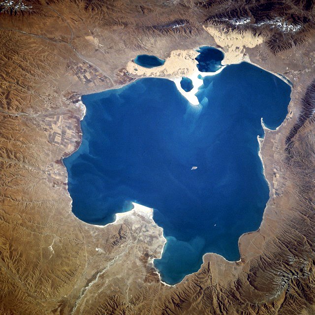
Deutsch: Qinghai-See, China - November 1994
English: Qinghai Lake, China - also, originally known as Koko Nor in Mongolian and Tso Ngonpo in Tibetan - November 1994
Español: Lago Qinghai, China - Noviembre 1994
中文:​青海湖
Tarix Taken on 8 noyabr 1994, 04:13:36 GMT
Mənbə https://eol.jsc.nasa.gov/sseop/EFS/photoinfo.pl?PHOTO=STS066-118-23
https://eol.jsc.nasa.gov/SearchPhotos/photo.pl?mission=STS066&roll=118&frame=23
Müəllif NASA
İcazə
(Faylın təkrar istifadəsi)
Public domainPublic domainfalsefalse
Public domain This file is in the public domain in the United States because it was solely created by NASA. NASA copyright policy states that "NASA material is not protected by copyright unless noted". (See Template:PD-USGov, NASA copyright policy page or JPL Image Use Policy.)
Warnings:
  • Use of NASA logos, insignia and emblems is restricted per U.S. law 14 CFR 1221.
  • The NASA website hosts a large number of images from the Soviet/Russian space agency, and other non-American space agencies. These are not necessarily in the public domain.
  • Materials based on Hubble Space Telescope data may be copyrighted if they are not explicitly produced by the STScI.[1] See also {{PD-Hubble}} and {{Cc-Hubble}}.
  • The SOHO (ESA & NASA) joint project implies that all materials created by its probe are copyrighted and require permission for commercial non-educational use. [2]
  • Images featured on the Astronomy Picture of the Day (APOD) web site may be copyrighted. [3]
  • The National Space Science Data Center (NSSDC) site has been known to host copyrighted content. Its photo gallery FAQ states that all of the images in the photo gallery are in the public domain "Unless otherwise noted."
NASA information
InfoField

NASA Photo ID STS066-118-23
Image Caption: STS066-118-023 Qinghai Lake, Qinghai Province, China November 1994
Spacecraft nadir point: 38.0° N, 96.9° E
Photo center point: 37.0° N, 100.0° E
Nadir to Photo Center: East
Spacecraft Altitude: 161 nautical miles (298km)
Country or Geographic Name: CHINA
Features: CH'ING-HAI L., MOUNTAINS
Cloud Cover Percentage: 0 (0-10)%
Sun Elevation Angle: 34°
Sun Azimuth: 162°
Camera: Hasselblad
Focal Length: 100mm
Camera Tilt: 51 degrees
Format: 5046: Kodak, natural color positive, Lumiere 100/5046, ASA 100, standard base
Film Exposure: Normal
Qinghai Lake, with an area of 1770 square miles (4580 square kilometers) and a maximum depth of 108 feet (33 meters), is the largest natural lake in China. Situated in the eastern end of the desert environment of the Qaidam Basin in Qinghai Province, the lake's main source of recharge water is snowmelt from the encircling mountain ranges that rise in excess of 14 000 feet (4265 meters). Several small deltas with cultivated field patterns surround the lake. Qinghai Lake, one of many inland saline lakes in west-central and northwest China, exhibits sand deposits on its western shoreline as well as its eastern shoreline where the deposits extend into the lake.

Camera location37° 00′ 00″ N, 100° 00′ 00″ E Kartographer map based on OpenStreetMap.View this and other nearby images on: OpenStreetMapinfo 37.000000; 100.000000
This image or video was catalogued by one of the centers of the United States National Aeronautics and Space Administration (NASA) under Photo ID: STS066-118-23.

This tag does not indicate the copyright status of the attached work. A normal copyright tag is still required. See Commons:Licensing.
Other languages:

Afrikaans ∙ العربية ∙ беларуская (тарашкевіца) ∙ български ∙ Bahaso Jambi ∙ català ∙ čeština ∙ dansk ∙ Deutsch ∙ English ∙ español ∙ فارسی ∙ français ∙ galego ∙ magyar ∙ հայերեն ∙ Bahasa Indonesia ∙ italiano ∙ 日本語 ∙ македонски ∙ മലയാളം ∙ Nederlands ∙ polski ∙ português ∙ русский ∙ sicilianu ∙ slovenščina ∙ Türkçe ∙ українська ∙ 简体中文 ∙ 繁體中文 ∙ +/−

Başlıqlar

Bu faylın nəyi təmsil etdiyinə dair bir sətirlik izahat əlavə et
Tour du lac Qinghai

Bu faylda təsvir olunan elementlər

təsvir edir

Tour of Qinghai Lake ingilis

copyright status ingilis

ictimai mülkiyyət

yurisdiksiyasındadır: Amerika Birləşmiş Ştatları
təyinetmə üsulu: work of the federal government of the United States ingilis

yaranma tarixi

8 noyabr 1994

coordinates of the point of view ingilis

37°0'0.000"N, 100°0'0.000"E

media type ingilis

image/jpeg

Faylın tarixçəsi

Faylın əvvəlki versiyasını görmək üçün gün/tarix bölməsindəki tarixlərə klikləyin.

Tarix/VaxtMiniatürÖlçülərİstifadəçiŞərh
hal-hazırkı15:02, 10 oktyabr 200515:02, 10 oktyabr 2005 tarixindəki versiyanın miniatür görüntüsü640 × 640 (138 KB)Immanuel GielQinghai Lake, China - November 1994 '''Source''': from the English Wikipedia<br> image description [http://eol.jsc.nasa.gov/sseop/EFS/photoinfo.pl?PHOTO=STS066-118-23 here] en:Qinghai Lake {{PD-USGov-NASA}}

Faylın istifadəsi

Aşağıdakı səhifə bu faylı istifadə edir:

  • Kukunor

Faylın qlobal istifadəsi

Bu fayl aşağıdakı vikilərdə istifadə olunur:

  • ace.wikipedia.org layihəsində istifadəsi
    • Qinghai
  • ar.wikipedia.org layihəsində istifadəsi
    • طواف بحيرة تشينغهاي
  • ba.wikipedia.org layihəsində istifadəsi
    • Кукунор
    • Цинхай
  • bg.wikipedia.org layihəsində istifadəsi
    • Цинхай (езеро)
  • bn.wikipedia.org layihəsində istifadəsi
    • ক্ষেত্রফল অনুযায়ী হ্রদের তালিকা
    • চিংহাই হ্রদ
  • bo.wikipedia.org layihəsində istifadəsi
    • མཚོ་སྔོན
    • མཚོ་སྔོན་པོ
  • br.wikipedia.org layihəsində istifadəsi
    • Qinghai
  • ca.wikipedia.org layihəsində istifadəsi
    • Volta al llac Qinghai
  • cdo.wikipedia.org layihəsində istifadəsi
    • Hù-cūi-hŏk
  • ceb.wikipedia.org layihəsində istifadəsi
    • Qinghai Hu
  • cs.wikipedia.org layihəsində istifadəsi
    • Kukunor
    • Čching-chaj
  • cv.wikipedia.org layihəsində istifadəsi
    • Кукунор
  • da.wikipedia.org layihəsində istifadəsi
    • Qinghai-søen
    • Tour of Qinghai Lake
  • de.wikipedia.org layihəsində istifadəsi
    • Radikal 174
    • Qinghai-See
    • Grün und Blau in verschiedenen Sprachen
    • Wikipedia:Quiz/Ostasien (Fragen)
    • Buhahe
  • el.wikipedia.org layihəsində istifadəsi
    • Λίμνη Τσινγκχάι
  • en.wikipedia.org layihəsində istifadəsi
    • Qinghai Lake
    • User:Classical geographer
    • User:Phlyming
    • Template:User geographer
    • User:Gisbwoy
    • Wikipedia:WikiProject Lakes/Galleries/1
    • User:DAK4Blizzard
    • Four Seas
    • User:Gabrielsanz
    • User:Vivereb
    • User:Orbitalbuzzsaw
    • User:Campitibi
    • User:Don Stroud
    • User:Farding MastCell
    • User:AndrewSan12
    • User:Ivgemytlig
    • User:Tuba is loud
    • User:Heniwa
    • User:ScottLeeBloxdRoblox
    • User:BigGuyTheGreat
    • User:Naturalkilla76
  • eo.wikipedia.org layihəsində istifadəsi
    • Ĉinghajo
  • es.wikipedia.org layihəsində istifadəsi
    • Lago Qinghai
    • Vuelta al Lago Qinghai
  • et.wikipedia.org layihəsində istifadəsi
    • Kukunor
  • eu.wikipedia.org layihəsində istifadəsi
    • Qinghai lakua

Bu faylın qlobal istifadəsinə baxın.

Metaməlumatlar

Bu faylda fotoaparat və ya skanerlə əlavə olunmuş məlumatlar var. Əgər fayl sonradan olunubsa, bəzi parametrlər bu şəkildə göstərilənlərdən fərqli ola bilər.

OrientasiyaNormal
Üfüqi xətt72 dpi
Şaquli xətt72 dpi
Y və C komponetlərinə görə yerləşmə sırasıMərkəzləşdirilmiş
Exif versiyası2
Rəng sahəsisRGB
Mənbə — "https://az.wikipedia.org/wiki/Fayl:Qinghai_lake.jpg"
Informasiya Melumat Axtar