
Bu fayl Vikianbarda yerləşir. Açıqlama səhifəsindəki məlumatlar aşağıda göstərilib. Vikianbar azad lisenziyalı media anbarıdır. Siz də töhfə verə bilərsiniz. |
| İzah |
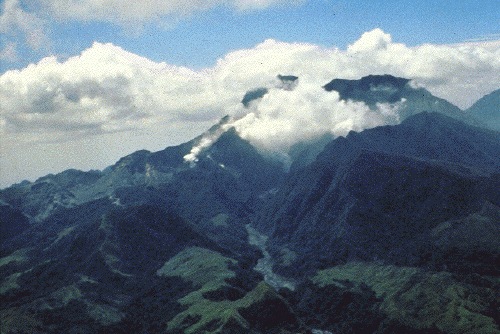
Mount Pinatubo in April 1991, before the onset of magmatic eruptions. Preeruption Mount Pinatubo, April 16, 1991. View from the northwest, up the Maraunot River valley. The river had become acidic and silty, owing to reactivation of the hydrothermal system and phreatic explosions of April 2, 1991 (the vents of which were just out of view at left edge of photograph). Steam was from 2-week-old fumaroles on the upper north slope of the volcano. The fumarole farthest to the right (behind a jagged ridge, right of the one visible on the valley floor) would later become the site of the preclimactic lava dome extrusion of June 7-12 (Hoblitt, Wolfe, and others, this volume). Mount Negron is behind and to the right of Pinatubo. (R.S. Punongbayan) |
| Tarix | |
| Mənbə | Figure 2A on Photographic Record of Rapid Geomorphic Change at Mount Pinatubo, 1991-94 |
| Müəllif | United States Geological Survey |
This image is in the public domain in the United States because it only contains materials that originally came from the United States Geological Survey, an agency of the United States Department of the Interior. For more information, see the official USGS copyright policy.
|
Faylın tarixçəsi
Faylın əvvəlki versiyasını görmək üçün gün/tarix bölməsindəki tarixlərə klikləyin.
| Tarix/Vaxt | Miniatür | Ölçülər | İstifadəçi | Şərh | |
|---|---|---|---|---|---|
| hal-hazırkı | 18:57, 12 oktyabr 2005 | | 500 × 334 (69 KB) | Ascánder | Mount Pinatubo in April 1991, before the onset of magmatic eruptions. (Probable) source: [http://pubs.usgs.gov/pinatubo/punong1/fig2a.jpg Fig.2A] on [http://pubs.usgs.gov/pinatubo/punong1/index.html] {{PD-USGov-Interior-USGS}} [[Category:Philippines] |
Faylın istifadəsi
Aşağıdakı səhifə bu faylı istifadə edir:
Faylın qlobal istifadəsi
Bu fayl aşağıdakı vikilərdə istifadə olunur:
- bg.wikipedia.org layihəsində istifadəsi
- cs.wikipedia.org layihəsində istifadəsi
- en.wikipedia.org layihəsində istifadəsi
- es.wikipedia.org layihəsində istifadəsi
- fi.wikipedia.org layihəsində istifadəsi
- fr.wikipedia.org layihəsində istifadəsi
- he.wikipedia.org layihəsində istifadəsi
- hy.wikipedia.org layihəsində istifadəsi
- io.wikipedia.org layihəsində istifadəsi
- it.wikipedia.org layihəsində istifadəsi
- ka.wikipedia.org layihəsində istifadəsi
- kk.wikipedia.org layihəsində istifadəsi
- ko.wikipedia.org layihəsində istifadəsi
- lt.wikipedia.org layihəsində istifadəsi
- nl.wikipedia.org layihəsində istifadəsi
- no.wikipedia.org layihəsində istifadəsi
- pam.wikipedia.org layihəsində istifadəsi
- pl.wikipedia.org layihəsində istifadəsi
- ru.wikipedia.org layihəsində istifadəsi
- sk.wikipedia.org layihəsində istifadəsi
- sr.wikipedia.org layihəsində istifadəsi