Butun axtardiqlarinizi tapmaq ucun buraya: DAXIL OLUN
  Mp4 Mp3 Axtar Yukle
  Video Axtar Yukle
  Shekil Axtar Yukle
  Informasiya Melumat Axtar
  Hazir Inshalar Toplusu
  AZERI CHAT + Tanishliq
  1-11 Sinif Derslikler Yukle
  Saglamliq Tibbi Melumat
  Whatsapp Plus Yukle(Yeni)

  • Ana səhifə
  • Təsadüfi
  • Yaxınlıqdakılar
  • Daxil ol
  • Nizamlamalar
İndi ianə et Əgər Vikipediya sizin üçün faydalıdırsa, bu gün ianə edin.

Fayl:Post Roman Balkans.jpg

  • Fayl
  • Müzakirə
  • Vikianbar üzərindən baxış
  • Lokal izah əlavə et
  • Fayl
  • Faylın tarixçəsi
  • Faylın istifadəsi
  • Faylın qlobal istifadəsi
  • Metaməlumatlar
Fayl:Post Roman Balkans.jpg
Sınaq göstərişi ölçüsü: 729 × 600 piksel. Digər ölçülər: 292 × 240 piksel | 583 × 480 piksel | 933 × 768 piksel | 1.245 × 1.024 piksel | 2.038 × 1.677 piksel.
Faylın orijinalı (2.038 × 1.677 piksel, fayl həcmi: 721 KB, MIME növü: image/jpeg)
Bu fayl Vikianbarda yerləşir. Açıqlama səhifəsindəki məlumatlar aşağıda göstərilib.
Vikianbar azad lisenziyalı media anbarıdır. Siz də töhfə verə bilərsiniz.

Bilindik köyü

Xülasə

İzahPost Roman Balkans.jpg

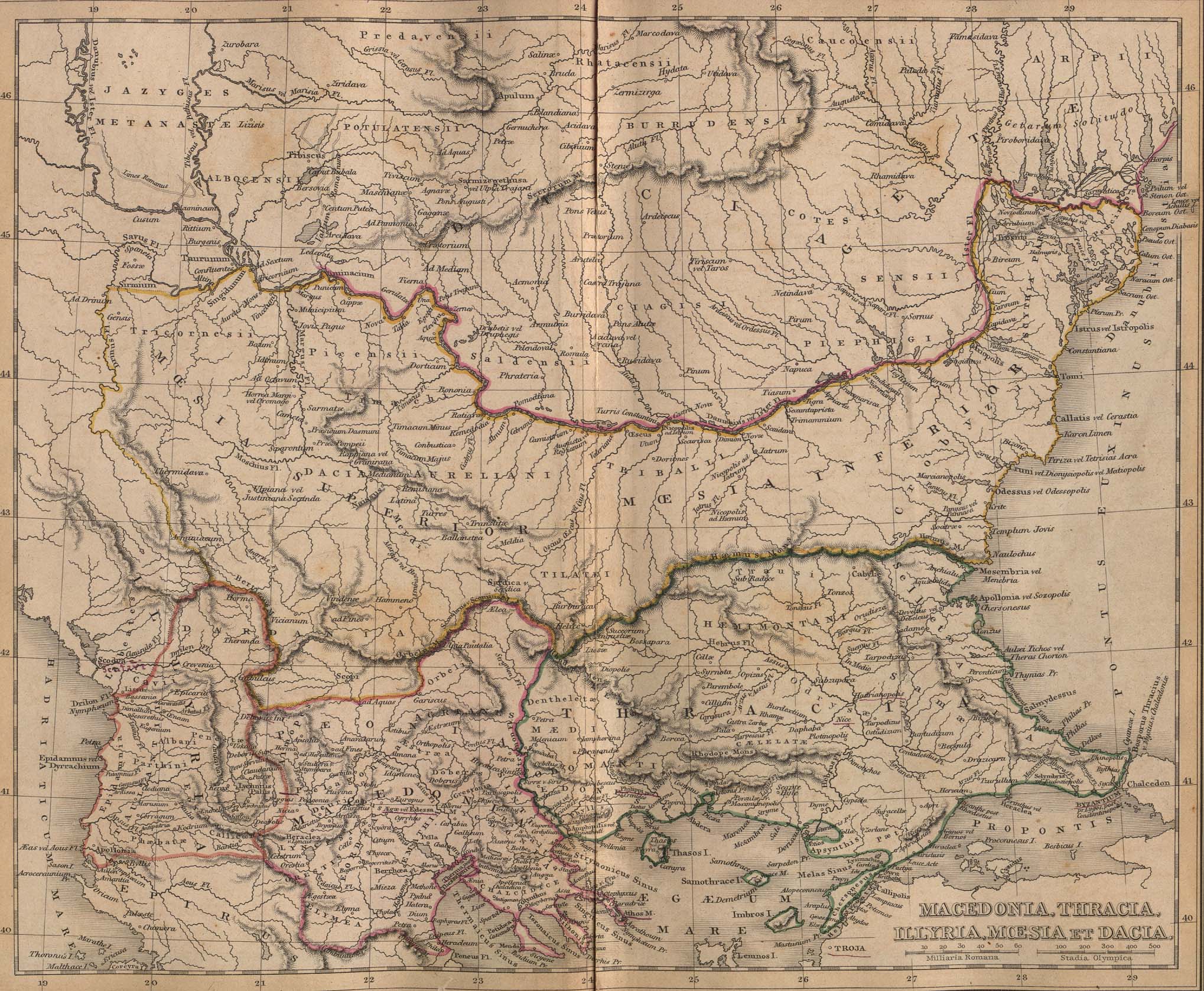
Macedonia, Thracia, Illyria, Moesia, Dacia,(Map X),"Comment on Map from author; Map X., & c. - Although most portions of this map are well represented, still we have a deficiency in the classical portion, as it has not been yet sufficiently examined by those who are capable of deciding and systematizing the comparative geography."

  • This map includes even 2nd century AD (i.e. Adrianopolis) cities and perhaps even later ones.
  • This map is a Post-Roman conquest map, the atlas was called "classical" and included many types of maps.
  • Locations of many cities, tribes or other features are according to 1849 scholarship and not up to date. For example, many cities shown have not been identified yet and Findlay made arbirtrary conclusions. A great omission is that Lake Prespas are missing.
Tarix 1849
Mənbə A classical atlas, to illustrate ancient geography: comprised in twenty-five maps, showing the various divisions of the world as known to the ancients : composed from the most authentic sources with an index of the ancient and modern names,Alexander G. Findlay,Publisher;Harper,1849
Müəllif Alexander G. Findlay
İcazə
(Faylın təkrar istifadəsi)
Public domainPublic domainfalsefalse
Public domain

This work is in the public domain in its country of origin and other countries and areas where the copyright term is the author's life plus 70 years or fewer.


You must also include a United States public domain tag to indicate why this work is in the public domain in the United States.
 Note that a few countries have copyright terms longer than 70 years: Mexico has 100 years, Jamaica has 95 years, Colombia has 80 years, and Guatemala and Samoa have 75 years. This image may not be in the public domain in these countries, which moreover do not implement the rule of the shorter term. Honduras has a general copyright term of 75 years, but it does implement the rule of the shorter term. Copyright may extend on works created by French who died for France in World War II (more information), Russians who served in the Eastern Front of World War II (known as the Great Patriotic War in Russia) and posthumously rehabilitated victims of Soviet repressions (more information).
Bu fayl bütün əlaqəli və qonşu hüquqlar da daxil olmaqla, müəllif hüquqları qanununa əsasən məlum məhdudiyyətlərdən azad olduğu müəyyən edilmişdir.
https://creativecommons.org/publicdomain/mark/1.0/PDMCreative Commons Public Domain Mark 1.0falsefalse
Digər versiyalar

Başlıqlar

Bu faylın nəyi təmsil etdiyinə dair bir sətirlik izahat əlavə et
Alexander G. Findlay Klasik Atlas Antik Coğrafyayı Resmedecek, New York, 1849

Bu faylda təsvir olunan elementlər

təsvir edir

copyright status ingilis

ictimai mülkiyyət

yaranma tarixi

1849

data size ingilis

738.382 Bayt

hündürlüyü/boyu

1.677 piksel

eni

2.038 piksel

media type ingilis

image/jpeg

checksum ingilis

384207f1b2bc1a2205dad04b9fda27202d72a2ef

təyinetmə üsulu: SHA-1

Faylın tarixçəsi

Faylın əvvəlki versiyasını görmək üçün gün/tarix bölməsindəki tarixlərə klikləyin.

Tarix/VaxtMiniatürÖlçülərİstifadəçiŞərh
hal-hazırkı18:49, 28 yanvar 201018:49, 28 yanvar 2010 tarixindəki versiyanın miniatür görüntüsü2.038 × 1.677 (721 KB)WikiEditor2004Reverted to version as of 01:28, 27 March 2005 - restored original version which has more historical value. please upload your whitened version as a new separate file, not over this one, thank you
10:02, 17 may 200910:02, 17 may 2009 tarixindəki versiyanın miniatür görüntüsü2.038 × 1.677 (1,1 MB)Alex:Dwhitened
01:28, 27 mart 200501:28, 27 mart 2005 tarixindəki versiyanın miniatür görüntüsü2.038 × 1.677 (721 KB)Karmosin~commonswikiClassical Balkans: from ''Map from "rothers Publishers, New York, 1849A Classical Atlas to Illustrate Ancient Geography,'' Alexander G. Findlay, Harper and B ros. NY 1849 {{PD-art}} category:History of the Balkans

Faylın istifadəsi

Aşağıdakı səhifə bu faylı istifadə edir:

  • Frakiya

Faylın qlobal istifadəsi

Bu fayl aşağıdakı vikilərdə istifadə olunur:

  • ar.wikipedia.org layihəsində istifadəsi
    • تاريخ كوسوفو
  • arz.wikipedia.org layihəsində istifadəsi
    • ريسكوبوريس الاول (ملك)
  • azb.wikipedia.org layihəsində istifadəsi
    • تراکیا
  • ba.wikipedia.org layihəsində istifadəsi
    • Фракия
  • be-tarask.wikipedia.org layihəsində istifadəsi
    • Тракія
  • be.wikipedia.org layihəsində istifadəsi
    • Фракія
    • Усходняя Фракія
    • Кровічы
  • bg.wikipedia.org layihəsində istifadəsi
    • Девол (град)
    • История на Косово
  • ca.wikipedia.org layihəsində istifadəsi
    • Història de Kosovo
  • cs.wikipedia.org layihəsində istifadəsi
    • Portál:Balkán
    • Portál:Balkán/úvod
  • en.wikipedia.org layihəsində istifadəsi
    • Talk:Timișoara
    • Talk:Thrace
    • User:Matia.gr/Evidence
    • Talk:Demographic history of Macedonia/Archive 4
    • Talk:North Macedonia/Archive 13
    • Talk:Spartacus/Archive 1
    • User:Falcaorib/Ancient Empires (150-500 AD)
    • User:Falcaorib/Balkans maps
  • eo.wikipedia.org layihəsində istifadəsi
    • Trakio
  • es.wikipedia.org layihəsində istifadəsi
    • Historia de Kosovo
    • Tracia Oriental
  • gl.wikipedia.org layihəsində istifadəsi
    • Dacia
  • he.wikipedia.org layihəsində istifadəsi
    • דאקיה
  • hr.wikipedia.org layihəsində istifadəsi
    • Povijest Albanije
  • hy.wikipedia.org layihəsində istifadəsi
    • Արևելյան Թրակիա
  • it.wikipedia.org layihəsində istifadəsi
    • Macedonia (regione storica)
  • ja.wikipedia.org layihəsində istifadəsi
    • 利用者‐会話:Vacsora/FArchive
    • マルクス・テレンティウス・ウァッロ・ルクッルス
  • mk.wikipedia.org layihəsində istifadəsi
    • Мизија
  • nl.wikipedia.org layihəsində istifadəsi
    • Portaal:Thracië
    • Portaal:Bulgarije
    • Portaal:Bulgarije/verwante portalen
  • pt.wikipedia.org layihəsində istifadəsi
    • Trácia
  • ro.wikipedia.org layihəsində istifadəsi
    • Istoria provinciei Kosovo
  • ru.wikipedia.org layihəsində istifadəsi
    • Фракия
    • Древняя Македония
    • Дакия
    • Мёзия
    • Армия Древней Македонии
    • Восточная Фракия
    • Мёзы
    • Марк Теренций Варрон Лукулл
    • Древняя Фракия
    • Кробизы
    • Котис II
    • Рэйздос
    • Котис III

Bu faylın qlobal istifadəsinə baxın.

Metaməlumatlar

Bu faylda fotoaparat və ya skanerlə əlavə olunmuş məlumatlar var. Əgər fayl sonradan olunubsa, bəzi parametrlər bu şəkildə göstərilənlərdən fərqli ola bilər.

JPEG şəkil şərhiFile written by Adobe Photoshop¨ 4.0
Mənbə — "https://az.wikipedia.org/wiki/Fayl:Post_Roman_Balkans.jpg"
Informasiya Melumat Axtar