Butun axtardiqlarinizi tapmaq ucun buraya: DAXIL OLUN
  Mp4 Mp3 Axtar Yukle
  Video Axtar Yukle
  Shekil Axtar Yukle
  Informasiya Melumat Axtar
  Hazir Inshalar Toplusu
  AZERI CHAT + Tanishliq
  1-11 Sinif Derslikler Yukle
  Saglamliq Tibbi Melumat
  Whatsapp Plus Yukle(Yeni)

  • Ana səhifə
  • Təsadüfi
  • Yaxınlıqdakılar
  • Daxil ol
  • Nizamlamalar
İndi ianə et Əgər Vikipediya sizin üçün faydalıdırsa, bu gün ianə edin.

Fayl:PonticKingdom.png

  • Fayl
  • Müzakirə
  • Lokal izah əlavə et
  • Fayl
  • Faylın tarixçəsi
  • Faylın istifadəsi
  • Faylın qlobal istifadəsi
  • Metaməlumatlar
Fayl:PonticKingdom.png
Sınaq göstərişi ölçüsü: 718 × 600 piksel. Digər ölçülər: 287 × 240 piksel | 575 × 480 piksel | 919 × 768 piksel | 1.226 × 1.024 piksel | 1.551 × 1.296 piksel.

Faylın orijinalı (1.551 × 1.296 piksel, fayl həcmi: 219 KB, MIME növü: image/png)

Bu fayl Vikianbarda yerləşir. Açıqlama səhifəsindəki məlumatlar aşağıda göstərilib.
Vikianbar azad lisenziyalı media anbarıdır. Siz də töhfə verə bilərsiniz.

Xülasə

This historical map image could be re-created using vector graphics as an SVG file. This has several advantages; see Commons:Media for cleanup for more information. If an SVG form of this image is available, please upload it and afterwards replace this template with {{vector version available|new image name}}.
It is recommended to name the SVG file “PonticKingdom.svg”—then the template Vector version available (or Vva) does not need the new image name parameter.
İzahPonticKingdom.png
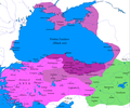
English: Map of the Kingdom of Pontus
 
Before the reign of Mithridates VI
 
After his conquests
 
His conquests in the first Mithridatic wars
; little adds (ancient shorelines & some greek colonies under Mithridate's rule) according with V. Yanko-Hombach, A.S. Gilbert, N. Panin, P. M. Dolukhanov: The Black Sea Flood Question: Changes in Coastline, Climate, and Human Settlement, Springer, Netherlands, 2007, and with Appianus, Plutarchus & Strabo.
Tarix 9 iyul 2009
Mənbə I (Javierfv1212 (talk)) created this work entirely by myself. Sources, Cambridge Ancient history volume 9, Penguin atlas of Greek history and the Foreign Policy of Mithridates VI Eupator.
Müəllif Javierfv1212 (talk)

Lisenziya

Public domainPublic domainfalsefalse
Public domain This work has been released into the public domain by its author, Javierfv1212 at ingilis Vikipediya. This applies worldwide.
In some countries this may not be legally possible; if so:
Javierfv1212 grants anyone the right to use this work for any purpose, without any conditions, unless such conditions are required by law.Public domainPublic domainfalsefalse

Orijinal yükləmə gündəliyi

Transferred from en.wikipedia to Commons by Falcorian using CommonsHelper.

The original description page was here. All following user names refer to en.wikipedia.
  • 2009-07-19 23:42 Javierfv1212 1551×1296× (205182 bytes) {{Information |Description = Map of the Kingdom of Pontus, Before the reign of mithridates VI (darkest purple), after his conquests (purple), and his conquests in the first Mithridatic wars (pink). |Source = I (~~~) created this work entirel

Başlıqlar

Bu faylın nəyi təmsil etdiyinə dair bir sətirlik izahat əlavə et

Bu faylda təsvir olunan elementlər

təsvir edir

copyright status ingilis

müəllif hüquqları ilə qorunur, lakin müəllif hüquqlarının sahibi tərəfindən ictimai istifadəyə verilmişdir

lisenziya

released into the public domain by the copyright holder ingilis

yaranma tarixi

9 iyul 2009

Faylın tarixçəsi

Faylın əvvəlki versiyasını görmək üçün gün/tarix bölməsindəki tarixlərə klikləyin.

Tarix/VaxtMiniatürÖlçülərİstifadəçiŞərh
hal-hazırkı13:20, 15 noyabr 202413:20, 15 noyabr 2024 tarixindəki versiyanın miniatür görüntüsü1.551 × 1.296 (219 KB)GrandEscogriffelocation of Ancyra
02:00, 9 dekabr 201702:00, 9 dekabr 2017 tarixindəki versiyanın miniatür görüntüsü1.551 × 1.296 (265 KB)SteinsplitterBotBot: Image rotated by 90°
00:00, 9 dekabr 201700:00, 9 dekabr 2017 tarixindəki versiyanın miniatür görüntüsü1.296 × 1.551 (316 KB)SteinsplitterBotBot: Image rotated by 270°
17:54, 22 sentyabr 201617:54, 22 sentyabr 2016 tarixindəki versiyanın miniatür görüntüsü1.551 × 1.296 (265 KB)HohumLighten water area
11:21, 9 avqust 201611:21, 9 avqust 2016 tarixindəki versiyanın miniatür görüntüsü1.551 × 1.296 (260 KB)MAXHODetails : more cities & shoreline of this time
20:57, 1 oktyabr 201520:57, 1 oktyabr 2015 tarixindəki versiyanın miniatür görüntüsü1.551 × 1.296 (249 KB)Spiridon Ion CepleanuCosmetic again
12:55, 30 sentyabr 201512:55, 30 sentyabr 2015 tarixindəki versiyanın miniatür görüntüsü1.551 × 1.296 (247 KB)Spiridon Ion CepleanuCosmetic colours & background names
14:21, 7 aprel 201414:21, 7 aprel 2014 tarixindəki versiyanın miniatür görüntüsü1.551 × 1.296 (225 KB)Spiridon Ion CepleanuLittle changes (ancient shoreline & some greek colonies under Pontic rule) according with V. Yanko-Hombach, A.S. Gilbert, N. Panin, P. M. Dolukhanov: ''The Black Sea Flood Question: Changes in Coastline, Climate, and Human Settlement'', Springer, Nethe...
04:14, 20 iyul 200904:14, 20 iyul 2009 tarixindəki versiyanın miniatür görüntüsü1.551 × 1.296 (200 KB)File Upload Bot (Magnus Manske) {{BotMoveToCommons|en.wikipedia|year={{subst:CURRENTYEAR}}|month={{subst:CURRENTMONTHNAME}}|day={{subst:CURRENTDAY}}}} {{Information |Description={{en|Map of the Kingdom of Pontus, Before the reign of mithridates VI (darkest purple), after his conquests

Faylın istifadəsi

Aşağıdakı səhifə bu faylı istifadə edir:

  • Pont çarlığı

Faylın qlobal istifadəsi

Bu fayl aşağıdakı vikilərdə istifadə olunur:

  • ar.wikipedia.org layihəsində istifadəsi
    • مملكة بوسبوران
    • مملكة البنطس
    • حروب ميثراداس
  • ast.wikipedia.org layihəsində istifadəsi
    • Reinu del Ponto
  • azb.wikipedia.org layihəsində istifadəsi
    • مهرداد ساواشلاری
    • پونتوس شاهلیغی
  • bg.wikipedia.org layihəsində istifadəsi
    • Митридат VI
    • Митридатови войни
    • Боспорско царство
    • Понтийско царство
  • br.wikipedia.org layihəsində istifadəsi
    • Mithridates Eupator
  • ca.wikipedia.org layihəsində istifadəsi
    • Regne del Pont
    • Guerres Mitridàtiques
  • cs.wikipedia.org layihəsində istifadəsi
    • Mithridatés VI. Pontský
    • Pontus
    • Mithridatské války
  • da.wikipedia.org layihəsində istifadəsi
    • Det Bosporanske Rige
  • de.wikipedia.org layihəsində istifadəsi
    • Königreich Pontos
  • el.wikipedia.org layihəsində istifadəsi
    • Α΄ Μιθριδατικός Πόλεμος
    • Δυναστεία των Μιθριδατιδών
    • Νομίσματα του Πόντου
  • en.wikipedia.org layihəsində istifadəsi
    • Bosporan Kingdom
    • Mithridatic Wars
    • Kingdom of Pontus
    • Mithridates VI Eupator
    • Classical Anatolia
    • Romania in Antiquity
    • Battle of Histria
    • Pontic coinage
    • User:Eumulos/Bosporan Kingdom
    • User:WildFields/sandbox
    • User:Falcaorib/Ancient Empires (300 BC-01 AD)
    • User:Falcaorib/Greece
    • User:Falcaorib/Turkey and Ottoman Empire
    • User:Falcaorib/Iran
  • es.wikipedia.org layihəsində istifadəsi
    • Mitrídates VI
    • Batalla de Queronea (86 a. C.)
    • Guerras mitridáticas
    • Reino del Ponto
    • Portal:Edad Antigua
  • et.wikipedia.org layihəsində istifadəsi
    • Rooma vabariik
  • eu.wikipedia.org layihəsində istifadəsi
    • Pontoko Erresuma
  • fa.wikipedia.org layihəsində istifadəsi
    • جنگ‌های مهردادی
    • کاربر:Hosseiniran/پادشاهی پنتوس
    • پادشاهی پونتوس
  • fr.wikipedia.org layihəsində istifadəsi
    • Mer Noire
    • Pompée
    • Mithridate VI
    • Liste des ports antiques
    • Première guerre de Mithridate

Bu faylın qlobal istifadəsinə baxın.

Metaməlumatlar

Bu faylda fotoaparat və ya skanerlə əlavə olunmuş məlumatlar var. Əgər fayl sonradan olunubsa, bəzi parametrlər bu şəkildə göstərilənlərdən fərqli ola bilər.

Üfüqi xətt37,79 dpc
Şaquli xətt37,79 dpc
Mənbə — "https://az.wikipedia.org/wiki/Fayl:PonticKingdom.png"
Informasiya Melumat Axtar