Butun axtardiqlarinizi tapmaq ucun buraya: DAXIL OLUN
  Mp4 Mp3 Axtar Yukle
  Video Axtar Yukle
  Shekil Axtar Yukle
  Informasiya Melumat Axtar
  Hazir Inshalar Toplusu
  AZERI CHAT + Tanishliq
  1-11 Sinif Derslikler Yukle
  Saglamliq Tibbi Melumat
  Whatsapp Plus Yukle(Yeni)

  • Ana səhifə
  • Təsadüfi
  • Yaxınlıqdakılar
  • Daxil ol
  • Nizamlamalar
İndi ianə et Əgər Vikipediya sizin üçün faydalıdırsa, bu gün ianə edin.

Fayl:PNW-straits.jpg

  • Fayl
  • Müzakirə
  • Vikianbar üzərindən baxış
  • Lokal izah əlavə et
  • Fayl
  • Faylın tarixçəsi
  • Faylın istifadəsi
  • Faylın qlobal istifadəsi
  • Metaməlumatlar
Fayl:PNW-straits.jpg
Daha yüksək versiyası yoxdur.
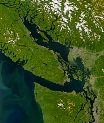
PNW-straits.jpg (336 × 396 piksel, fayl həcmi: 128 KB, MIME növü: image/jpeg)
Bu fayl Vikianbarda yerləşir. Açıqlama səhifəsindəki məlumatlar aşağıda göstərilib.
Vikianbar azad lisenziyalı media anbarıdır. Siz də töhfə verə bilərsiniz.
This image is very small, unfixably too light/dark, or may not adequately illustrate the subject of the image. If a higher-quality version of this particular image is available, please replace this one; otherwise, a supplemental image illustrating this subject and available under a free license should be found or provided and uploaded as a separate file.

Please see Category:Image cleanup templates for templates used to mark images that only need a clean-up. For more help, see Commons:Media for cleanup#Low quality images.


العربية ∙ беларуская (тарашкевіца) ∙ català ∙ čeština ∙ Deutsch ∙ English ∙ español ∙ فارسی ∙ suomi ∙ français ∙ galego ∙ magyar ∙ italiano ∙ 日本語 ∙ ಕನ್ನಡ ∙ 한국어 ∙ македонски ∙ മലയാളം ∙ Plattdüütsch ∙ Nederlands ∙ norsk ∙ polski ∙ português ∙ русский ∙ sicilianu ∙ slovenščina ∙ svenska ∙ Tiếng Việt ∙ 中文 ∙ 中文(简体) ∙ 中文(繁體) ∙ 中文(臺灣) ∙ +/−

Xülasə

İzahPNW-straits.jpg Satellite image of the Strait of Georgia, Strait of Juan de Fuca, and surrounding region. The image was acquired by the Sea-viewing Wide Field-of-view Sensor (SeaWiFS) on August 9, 2001. Original image cropped to highlight the Strait of Georgia.
Tarix 9 avqust 2001
Mənbə NASAEarth Observatory, http://earthobservatory.nasa.gov/Newsroom/NewImages/images.php3?img_id=5051
Müəllif The SeaWiFS Project, NASA/Goddard Space Flight Center, and ORBIMAGE

Lisenziya

Public domainPublic domainfalsefalse
Public domain This image is from the Sea-viewing Wide Field-of-view Sensor (SeaWiFS) Project and more than 5 years old.

Satellite data captured by the SeaWIFS sensor are released into the public domain 5 years after capture. Data less than five years old can be re-used only for educational or scientific purposes; any commercial use of such images must be coordinated with GeoEye. [1]

Public domainPublic domainfalsefalse
Public domain This work has been released into the public domain by its copyright holder, GeoEye. This applies worldwide.
In some countries this may not be legally possible; if so:
GeoEye grants anyone the right to use this work for any purpose, without any conditions, unless such conditions are required by law.

Public domainPublic domainfalsefalse

Başlıqlar

Bu faylın nəyi təmsil etdiyinə dair bir sətirlik izahat əlavə et

Bu faylda təsvir olunan elementlər

təsvir edir

copyright status ingilis

müəllif hüquqları ilə qorunur, lakin müəllif hüquqlarının sahibi tərəfindən ictimai istifadəyə verilmişdir

lisenziya

released into the public domain by the copyright holder ingilis

yaranma tarixi

9 avqust 2001

media type ingilis

image/jpeg

Faylın tarixçəsi

Faylın əvvəlki versiyasını görmək üçün gün/tarix bölməsindəki tarixlərə klikləyin.

Tarix/VaxtMiniatürÖlçülərİstifadəçiŞərh
hal-hazırkı06:55, 22 aprel 200806:55, 22 aprel 2008 tarixindəki versiyanın miniatür görüntüsü336 × 396 (128 KB)Pfly{{Information |Description=Satellite image of the Strait of Georgia, Strait of Juan de Fuca, and surrounding region. The image was acquired by the Sea-viewing Wide Field-of-view Sensor (SeaWiFS) on

Faylın istifadəsi

Aşağıdakı səhifə bu faylı istifadə edir:

  • Seliş dənizi

Faylın qlobal istifadəsi

Bu fayl aşağıdakı vikilərdə istifadə olunur:

  • ar.wikipedia.org layihəsində istifadəsi
    • بحر ساليش
    • مضيق جورجيا
  • ast.wikipedia.org layihəsində istifadəsi
    • Estrechu de Georgia
  • br.wikipedia.org layihəsində istifadəsi
    • Strizh-mor Juan de Fuca
  • ca.wikipedia.org layihəsində istifadəsi
    • Estret de Juan de Fuca
  • cv.wikipedia.org layihəsində istifadəsi
    • Селиш тинĕсĕ
  • de.wikipedia.org layihəsində istifadəsi
    • Salish Sea
  • en.wikipedia.org layihəsində istifadəsi
    • Strait of Georgia
    • Salish Sea
    • User talk:Qexigator/Books/Vancouver & British Columbia: exploration and colonisation
    • List of fishes of the Salish Sea
  • eo.wikipedia.org layihəsində istifadəsi
    • Saliŝa maro
  • es.wikipedia.org layihəsində istifadəsi
    • Estrecho de Georgia
    • Mar de los Salish
  • fa.wikipedia.org layihəsində istifadəsi
    • دریای سالیش
  • fi.wikipedia.org layihəsində istifadəsi
    • Georgiansalmi
  • fr.wikipedia.org layihəsində istifadəsi
    • Géographie de la Colombie-Britannique
    • Mer des Salish
    • Utilisateur:Skiff/A illustrer
  • fr.wiktionary.org layihəsində istifadəsi
    • Nouvelle-Géorgie
  • fy.wikipedia.org layihəsində istifadəsi
    • Strjitte fan Georgia
    • Strjitte fan Juan de Fuca
    • Salisjaanske See
  • he.wikipedia.org layihəsində istifadəsi
    • מצר ג'ורג'יה
  • id.wikipedia.org layihəsində istifadəsi
    • Selat Georgia
  • is.wikipedia.org layihəsində istifadəsi
    • Salish-haf
  • it.wikipedia.org layihəsində istifadəsi
    • Mare dei Salish
  • ja.wikipedia.org layihəsində istifadəsi
    • ファンデフカ海峡
  • ko.wikipedia.org layihəsində istifadəsi
    • 후안 데 푸카 해협
    • 조지아 해협
    • 세일리시해
  • lt.wikipedia.org layihəsində istifadəsi
    • Sališų jūra
  • lv.wikipedia.org layihəsində istifadəsi
    • Sališu jūra
  • mhr.wikipedia.org layihəsində istifadəsi
    • Селиш теҥыз
  • mk.wikipedia.org layihəsində istifadəsi
    • Салишко Море
  • ms.wikipedia.org layihəsində istifadəsi
    • Laut Salish
  • nl.wikipedia.org layihəsində istifadəsi
    • Straat van Georgia
  • no.wikipedia.org layihəsində istifadəsi
    • Juan de Fucasundet
  • pl.wikipedia.org layihəsində istifadəsi
    • Salish Sea
  • pt.wikipedia.org layihəsində istifadəsi
    • Estreito de Juan de Fuca
  • ru.wikipedia.org layihəsində istifadəsi
    • Селиш
    • Пролив Джорджии
  • sh.wikipedia.org layihəsində istifadəsi
    • Sališko more
  • tr.wikipedia.org layihəsində istifadəsi
    • Georgia Boğazı
    • Juan de Fuca Boğazı
  • uk.wikipedia.org layihəsində istifadəsi
    • Море Селіш
    • Джорджія (протока)
  • ur.wikipedia.org layihəsində istifadəsi
    • بحیرہ ساليش
  • vi.wikipedia.org layihəsində istifadəsi
    • Biển Salish
  • zh-yue.wikipedia.org layihəsində istifadəsi
    • 薩利希海

Bu faylın qlobal istifadəsinə baxın.

Metaməlumatlar

Bu faylda fotoaparat və ya skanerlə əlavə olunmuş məlumatlar var. Əgər fayl sonradan olunubsa, bəzi parametrlər bu şəkildə göstərilənlərdən fərqli ola bilər.

OrientasiyaNormal
Üfüqi xətt72 dpi
Şaquli xətt72 dpi
Proqram təminatıAdobe Photoshop CS2 Macintosh
Faylın dəyişməsi tarixi və vaxtı23:42, 21 aprel 2008
Rəng sahəsisRGB
Mənbə — "https://az.wikipedia.org/wiki/Fayl:PNW-straits.jpg"
Informasiya Melumat Axtar