.svg)

Bu SVG-faylın PNG formatındakı bu görünüşünün ölçüsü: 541 × 541 piksel. Digər ölçülər: 240 × 240 piksel | 480 × 480 piksel | 768 × 768 piksel | 1.024 × 1.024 piksel | 2.048 × 2.048 piksel.
Faylın orijinalı (SVG faylı, nominal olaraq 541 × 541 piksel, faylın ölçüsü: 63 KB)
Bu fayl Vikianbarda yerləşir. Açıqlama səhifəsindəki məlumatlar aşağıda göstərilib. Vikianbar azad lisenziyalı media anbarıdır. Siz də töhfə verə bilərsiniz. |
.svg)
Xülasə
| İzah |
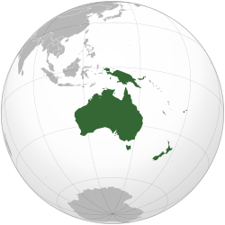
English: Orthographic map of Oceania. |
| Tarix | |
| Mənbə | Own work based on: Australia (orthographic projection).svg |
| Müəllif | Ch1902 |
| SVG genesis |
.svg)
Lisenziya
I, the copyright holder of this work, hereby publish it under the following licenses:
Bu fayl Creative Commons Attribution-Share Alike 3.0 Unported lisenziyası altında yayımlanır.
- Siz heç bir məhdudiyyət olmadan:
- paylaşa bilərsiniz – əsəri köçürə, paylaya və ötürə bilərsiniz
- remiks edə bilərsiniz – əsəri adaptasiya edə bilərsiniz
- Aşağıdakı şərtlərə əməl etməklə:
- istinad vermək – Müvafiq istinad verməli, lisenziyaya keçid əlavə etməli və dəyişikliklər edilib-edilmədiyini bildirməlisiniz . Siz bunu istənilən şəkildə edə bilərsiniz, lakin lisenziya verənin sizə şəxsən icazə verdiyini göstərən formada yox.
- bənzər paylaşma – Əsəri remix edirsinizsə, dəyişdirirsinizsə və ya üzərində iş aparırsınızsa, öz töhfələrinizi orijinalda olduğu kimi eyni və ya uyğun lisenziya altında yayımlamalısınız.

|
Bu sənədi GNU Azad Sənədləşdirmə Lisenziyası, Versiya 1.2 və ya Azad Proqram Fondu tərəfindən nəşr olunan hər hansı sonrakı versiya şərtlərinə əsasən dəyişməz bölmələr, ön qapaq mətnləri və arxa qapaq mətnləri olmadan köçürmək, yayımlamaq və / və ya dəyişdirmək üçün icazə verilir; Lisenziyanın bir nüsxəsi GNU Azad Sənədləşdirmə Lisenziyası adlı hissəyə daxil edilmişdir. |
İstədiyiniz lisenziyanı seçə bilərsiniz.
Faylın tarixçəsi
Faylın əvvəlki versiyasını görmək üçün gün/tarix bölməsindəki tarixlərə klikləyin.
| Tarix/Vaxt | Miniatür | Ölçülər | İstifadəçi | Şərh | |
|---|---|---|---|---|---|
| hal-hazırkı | 18:54, 6 fevral 2023 | | 541 × 541 (63 KB) | Golden Mage | A change to the map of Asia will first face debate from others. Hence, a change to the commonly accepted map of Oceania cannot be made without a wider consensus. |
| 06:33, 6 fevral 2023 |  | 541 × 541 (108 KB) | Kwamikagami | rv: then perhaps we need to change the Asia map to match. This is as defined in WP. | |
| 18:19, 5 fevral 2023 |  | 541 × 541 (63 KB) | Golden Mage | Reverted to the map that displays the more accepted definition of Oceania's boundaries. Widely accepted geopolitical definitions take precedence over mere geographical ones. The map of the Wikipedia page for Asia already includes the Maluku Islands. | |
| 05:01, 5 fevral 2023 |  | 541 × 541 (108 KB) | Treetoes023 | Reverted to version as of 06:27, 24 December 2022 (UTC) | |
| 05:00, 5 fevral 2023 |  | 541 × 541 (63 KB) | Treetoes023 | Reverted to version as of 13:25, 31 December 2022 (UTC) | |
| 04:55, 5 fevral 2023 |  | 541 × 541 (108 KB) | Treetoes023 | Reverted to version as of 00:31, 4 December 2022 (UTC) | |
| 13:25, 31 dekabr 2022 |  | 541 × 541 (63 KB) | Golden Mage | Reverted to the map that displays the more accepted definition of Oceania's boundaries. Widely accepted geopolitical definitions take precedence over mere geographical ones. | |
| 06:27, 24 dekabr 2022 |  | 541 × 541 (108 KB) | Kwamikagami | Reverted to version as of 00:31, 4 December 2022 (UTC) definition per WP-en | |
| 06:13, 22 dekabr 2022 |  | 541 × 541 (63 KB) | Golden Mage | Reverted to the map that displays the more accepted definition of Oceania's boundaries. | |
| 00:31, 4 dekabr 2022 |  | 541 × 541 (108 KB) | Kwamikagami | the Weber line divides Oceanic from Asian Wallacea |
Faylın istifadəsi
Aşağıdakı 34 səhifə bu faylı istifadə edir:
- Afro-Avrasiya
- Albaniya Prezidenti
- Almaniya Prezidenti
- Amasiya (qitə)
- Antarktida
- Atlantida
- Avstraliya (qitə)
- Azərbaycan Prezidenti
- Ermənistan Prezidenti
- Kenorlend
- Kolumbiya (qitə)
- Kolumbiya Prezidenti
- Latviya Prezidenti
- Lavrasiya
- Lemuriya
- Mu
- Nena (qitə)
- Pangeya
- Pannotiya
- Qondvana
- Rodiniya
- Terra Australis Incognita
- Türkmənistan Prezidenti
- Türkmənistan prezidentlərinin siyahısı
- Ur (qitə)
- Vaalbara
- İlham Əliyevin prezidentliyi
- İstifadəçi:A.Aida88
- İstifadəçi:Həsən İmanov
- Şablon:Dünya dövlətlərinin başçıları
- Şablon:Qitələr
- Portal:Coğrafiya
- Portal:Coğrafiya/Qitələr
- Portal:Coğrafiya/Əlaqəli portallar
Faylın qlobal istifadəsi
Bu fayl aşağıdakı vikilərdə istifadə olunur:
- ab.wikipedia.org layihəsində istifadəsi
- ady.wikipedia.org layihəsində istifadəsi
- af.wikipedia.org layihəsində istifadəsi
- Afrika
- Asië
- Europa
- Kiribati
- Noord-Amerika
- Suid-Amerika
- Vanuatu
- Guam
- Nieu-Seeland
- Sjabloon:Kontinente
- Australië
- Nauru
- Wellington, Nieu-Seeland
- Hoofstad
- Lys van hoofstede
- Sjabloon:Lande van Oseanië
- Honolulu
- Antarktika
- Gondwana
- Eurasië
- Laurasië
- Kategorie:Lande in Oseanië
- Lys van lande
- Fidji
- Canberra
- Hawaii
- Lys van nasionale leuses
- Clipperton
- Oseanië
- Norfolkeiland
- Amerikas
- Tonga
- Tuvalu
- Sjabloon:Hoofstede in Oseanië
- Palau
- Australië (kontinent)
- Afrika-Eurasië
- Samoa
- Marshalleilande
- Salomonseilande
- Papoea-Nieu-Guinee
- Gefedereerde State van Mikronesië
- Nukuʻalofa
- Port Moresby
- Apia
- Funafuti
- Honiara
- Majuro
Bu faylın qlobal istifadəsinə baxın.
.svg)
.svg)