Butun axtardiqlarinizi tapmaq ucun buraya: DAXIL OLUN
  Mp4 Mp3 Axtar Yukle
  Video Axtar Yukle
  Shekil Axtar Yukle
  Informasiya Melumat Axtar
  Hazir Inshalar Toplusu
  AZERI CHAT + Tanishliq
  1-11 Sinif Derslikler Yukle
  Saglamliq Tibbi Melumat
  Whatsapp Plus Yukle(Yeni)

  • Ana səhifə
  • Təsadüfi
  • Yaxınlıqdakılar
  • Daxil ol
  • Nizamlamalar
İndi ianə et Əgər Vikipediya sizin üçün faydalıdırsa, bu gün ianə edin.

Fayl:Mingachevir Reservoir, Azerbaijan.JPG

  • Fayl
  • Müzakirə
  • Vikianbar üzərindən baxış
  • Lokal izah əlavə et
  • Fayl
  • Faylın tarixçəsi
  • Faylın istifadəsi
  • Faylın qlobal istifadəsi
  • Metaməlumatlar
Fayl:Mingachevir Reservoir, Azerbaijan.JPG
Sınaq göstərişi ölçüsü: 398 × 599 piksel. Digər ölçülər: 159 × 240 piksel | 319 × 480 piksel | 510 × 768 piksel | 680 × 1.024 piksel | 1.361 × 2.048 piksel | 2.829 × 4.256 piksel.
Faylın orijinalı (2.829 × 4.256 piksel, fayl həcmi: 2,08 MB, MIME növü: image/jpeg)
Bu fayl Vikianbarda yerləşir. Açıqlama səhifəsindəki məlumatlar aşağıda göstərilib.
Vikianbar azad lisenziyalı media anbarıdır. Siz də töhfə verə bilərsiniz.

Xülasə

İzahMingachevir Reservoir, Azerbaijan.JPG
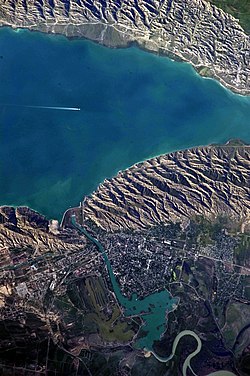
English: This detailed astronaut photograph highlights the southern Mingachevir Reservoir in north-central Azerbaijan. Folded layers of relatively young (less than 5. 3 million years old) sedimentary rock, explosive volcanic products (ash and tuff), and unconsolidated sediments form the grey hills along the northern and southern shorelines of the reservoir (image centre and right). Afternoon sun highlights distinctive parallel patterns in the hills that are the result of water and wind erosion of different rock layers exposed at the surface. The nearby city of Mingachevir (left) is split by the Kur River after it passes through the dam and hydroelectric power station complex at image top centre. The reservoir held approximately 15 billion cubic meters of water at the time this image was taken, with a total engineered capacity of 16 billion cubic meters. The width of the reservoir illustrated here is approximately 8 kilometres; a jet flying over the reservoir left a contrail midway between the shorelines.
Tarix 7 iyun 2010
Mənbə NASA Earth Observatory
Müəllif ISS Expedition 23 crew
Camera location40° 48′ 00″ N, 47° 06′ 00″ E Kartographer map based on OpenStreetMap.View this and other nearby images on: OpenStreetMapinfo 40.800000; 47.100000
This image or video was catalogued by Johnson Space Center of the United States National Aeronautics and Space Administration (NASA) under Photo ID: ISS023-E-35670.

This tag does not indicate the copyright status of the attached work. A normal copyright tag is still required. See Commons:Licensing.
Other languages:

Afrikaans ∙ العربية ∙ беларуская (тарашкевіца) ∙ български ∙ Bahaso Jambi ∙ català ∙ čeština ∙ dansk ∙ Deutsch ∙ English ∙ español ∙ فارسی ∙ français ∙ galego ∙ magyar ∙ հայերեն ∙ Bahasa Indonesia ∙ italiano ∙ 日本語 ∙ македонски ∙ മലയാളം ∙ Nederlands ∙ polski ∙ português ∙ русский ∙ sicilianu ∙ slovenščina ∙ Türkçe ∙ українська ∙ 简体中文 ∙ 繁體中文 ∙ +/−

Image captured with a Nikon D3S digital camera, and is provided by the ISS Crew Earth Observations experiment and Image Science & Analysis Laboratory, Johnson Space Center.

Lisenziya

Public domainPublic domainfalsefalse
Public domain This file is in the public domain in the United States because it was solely created by NASA. NASA copyright policy states that "NASA material is not protected by copyright unless noted". (See Template:PD-USGov, NASA copyright policy page or JPL Image Use Policy.)
Warnings:
  • Use of NASA logos, insignia and emblems is restricted per U.S. law 14 CFR 1221.
  • The NASA website hosts a large number of images from the Soviet/Russian space agency, and other non-American space agencies. These are not necessarily in the public domain.
  • Materials based on Hubble Space Telescope data may be copyrighted if they are not explicitly produced by the STScI.[1] See also {{PD-Hubble}} and {{Cc-Hubble}}.
  • The SOHO (ESA & NASA) joint project implies that all materials created by its probe are copyrighted and require permission for commercial non-educational use. [2]
  • Images featured on the Astronomy Picture of the Day (APOD) web site may be copyrighted. [3]
  • The National Space Science Data Center (NSSDC) site has been known to host copyrighted content. Its photo gallery FAQ states that all of the images in the photo gallery are in the public domain "Unless otherwise noted."
Annotations
InfoField
This image is annotated: View the annotations at Commons
2841
1462
383
750
4256
2829

Mingachevir Reservoir

3016
394
53
409
4256
2829

contrail

1681
686
218
245
4256
2829

dam

1218
1377
277
340
4256
2829

Mingachevir

287
2196
245
96
4256
2829

Kur River

Başlıqlar

Bu faylın nəyi təmsil etdiyinə dair bir sətirlik izahat əlavə et

Bu faylda təsvir olunan elementlər

təsvir edir

Mingəçevir SES

əhəmiyyətli hadisə

Expedition 23 ingilis

copyright status ingilis

ictimai mülkiyyət

təyinetmə üsulu: work of the federal government of the United States ingilis

yaranma tarixi

7 iyun 2010

coordinates of the point of view ingilis

40°48'0.000"N, 47°6'0.000"E

captured with ingilis

Nikon D3S ingilis

kataloq kodu

ISS023-E-35670

kataloq: Media catalogue of the Johnson Space Center ingilis

Faylın tarixçəsi

Faylın əvvəlki versiyasını görmək üçün gün/tarix bölməsindəki tarixlərə klikləyin.

Tarix/VaxtMiniatürÖlçülərİstifadəçiŞərh
hal-hazırkı10:00, 18 iyun 201810:00, 18 iyun 2018 tarixindəki versiyanın miniatür görüntüsü2.829 × 4.256 (2,08 MB)SteinsplitterBotBot: Image rotated by 270°
16:54, 7 iyun 201016:54, 7 iyun 2010 tarixindəki versiyanın miniatür görüntüsü4.256 × 2.829 (2,09 MB)Originalwana{{Information |Description={{en|1=This detailed astronaut photograph highlights the southern Mingachevir Reservoir in north-central Azerbaijan. Folded layers of relatively young (less than 5. 3 million years old) sedimentary rock, explosive volcanic p

Faylın istifadəsi

Aşağıdakı 4 səhifə bu faylı istifadə edir:

  • Bozdağ silsiləsi
  • Mingəçevir su anbarı
  • Şablon:Su anbarı
  • Şablon:Su anbarı/doc

Faylın qlobal istifadəsi

Bu fayl aşağıdakı vikilərdə istifadə olunur:

  • arz.wikipedia.org layihəsində istifadəsi
    • بحيره مينجاتشيڤير ريسيرڤوير
  • azb.wikipedia.org layihəsində istifadəsi
    • مینگه‌چئویر
  • az.wiktionary.org layihəsində istifadəsi
    • Mingəçevir su anbarı
  • be.wikipedia.org layihəsində istifadəsi
    • Мінгечаурская ГЭС
    • Мінгечэвірскае вадасховішча
  • ca.wikipedia.org layihəsində istifadəsi
    • Masses d'aigua de l'Azerbaidjan
  • ceb.wikipedia.org layihəsində istifadəsi
    • Mingechaur Sea
  • cs.wikipedia.org layihəsində istifadəsi
    • Mingačevirská přehradní nádrž
  • de.wikipedia.org layihəsində istifadəsi
    • Mingəçevir-Stausee
  • en.wikipedia.org layihəsində istifadəsi
    • Mingachevir
    • Bodies of water of Azerbaijan
    • Mingachevir reservoir
    • List of reservoirs by surface area
    • Hydroelectric power stations in Azerbaijan
  • eo.wikipedia.org layihəsində istifadəsi
    • Akvaĵoj en Azerbajĝano
    • Akvobaraĵo Mingacevir
  • es.wikipedia.org layihəsində istifadəsi
    • Azerbaiyán
    • Anexo:Embalses del mundo por superficie y volumen de agua
  • fa.wikipedia.org layihəsində istifadəsi
    • مخزن سد مینگه‌چویر
  • fi.wikipedia.org layihəsində istifadəsi
    • Mingəçevirin tekojärvi
  • fr.wikipedia.org layihəsində istifadəsi
    • Réservoir de Mingachevir
    • Barrage de Mingatchevir
  • fy.wikipedia.org layihəsində istifadəsi
    • Wetters yn Azerbeidzjan
  • he.wikipedia.org layihəsində istifadəsi
    • אזרבייג'ן
    • באקו
    • סטפנקרט
    • סומגאיט
    • גנג'ה
    • נחצ'יבאן (עיר)
    • שקי
    • מינגצ'ביר
    • לנצ'ראן
    • שירוואן
    • ייבלאח
    • שמקיר
    • תבנית:הערים הגדולות של אזרבייג'ן
  • hr.wikipedia.org layihəsində istifadəsi
    • Mingečaur
    • Mingečaursko jezero
  • hu.wikipedia.org layihəsində istifadəsi
    • Mingəçevir
    • Mingəçeviri-víztározó
  • hy.wikipedia.org layihəsində istifadəsi
    • Մինգեչաուրի հիդրոէլեկտրակայան
    • Մինգեչաուրի ջրամբար
  • id.wikipedia.org layihəsində istifadəsi
    • Pembangkit Listrik Tenaga Air Mingachevir
  • ilo.wikipedia.org layihəsində istifadəsi
    • Dagiti bagi ti danum ti Azerbaijan
  • it.wikipedia.org layihəsində istifadəsi
    • Bacino di Mingäçevir
    • Bacini dell'Azerbaigian
  • ja.wikipedia.org layihəsində istifadəsi
    • アゼルバイジャンの水域
  • ka.wikipedia.org layihəsində istifadəsi
    • მინგეჩაურის წყალსაცავი
    • აზერბაიჯანის წყალსაცავები
    • ჰიდროელექტროსადგურები აზერბაიჯანში

Bu faylın qlobal istifadəsinə baxın.

Metaməlumatlar

Bu faylda fotoaparat və ya skanerlə əlavə olunmuş məlumatlar var. Əgər fayl sonradan olunubsa, bəzi parametrlər bu şəkildə göstərilənlərdən fərqli ola bilər.

Kamera istehsalçısıNIKON CORPORATION
Kamera modeliNIKON D3S
Exposure time1/250 saniyə (0,004)
F nömrəsif/9
ISO sürət reytinqi200
Orijinal tarix və vaxt13:30, 8 may 2010
Fokus məsafəsi800 mm
İstifadəçi şərhiNASA#2007934
OrientasiyaNormal
Üfüqi xətt240 dpi
Şaquli xətt240 dpi
Proqram təminatıMicrosoft Windows Photo Gallery 6.0.6001.18000
Faylın dəyişməsi tarixi və vaxtı15:48, 7 iyun 2010
Ekspozisiya proqramıAçıqlıq üstünlüyü
Exif versiyası2.21
Tarix və vaxt rəqəmləşdirilir13:30, 8 may 2010
APEX shutter speed7,965784
Obyektiv gözü6,33985
APEX exposure bias0
Maximum land aperture5 APEX (f/5,66)
Metering modeDizaynlı
İşıq mənbəsiNaməlum
FlaşFlaş yandırılmadı
DateTime subseconds16
DateTimeOriginal subseconds16
DateTimeDigitized subseconds16
Rəng sahəsisRGB
Sensing methodBirkristallı matrisli rəngli sensor
Fayl mənbəsiRəqəmsal fotoapparat
Səhnə tipiFoto-təsvir birbaşa çəkilmişdir
Custom image processingNormal proses
Exposure modeAvtomatik ekspozisiya
Ağ balansıBəyaz balansın avtomatik tənzimlənməsi
Digital zoom ratio1
Focal length in 35 mm film800 mm
Scene capture typeStandart
Səhnə idarəsiHeç biri
KontrastNormal
DoymuşluqNormal
KəskinlikNormal
Subject distance rangeNaməlum
Mənbə — "https://az.wikipedia.org/wiki/Fayl:Mingachevir_Reservoir,_Azerbaijan.JPG"
Informasiya Melumat Axtar