
Sınaq göstərişi ölçüsü: 763 × 600 piksel. Digər ölçülər: 305 × 240 piksel | 611 × 480 piksel | 977 × 768 piksel | 1.280 × 1.006 piksel | 2.536 × 1.994 piksel.
Faylın orijinalı (2.536 × 1.994 piksel, fayl həcmi: 1.021 KB, MIME növü: image/jpeg)
Bu fayl Vikianbarda yerləşir. Açıqlama səhifəsindəki məlumatlar aşağıda göstərilib. Vikianbar azad lisenziyalı media anbarıdır. Siz də töhfə verə bilərsiniz. |
Xülasə
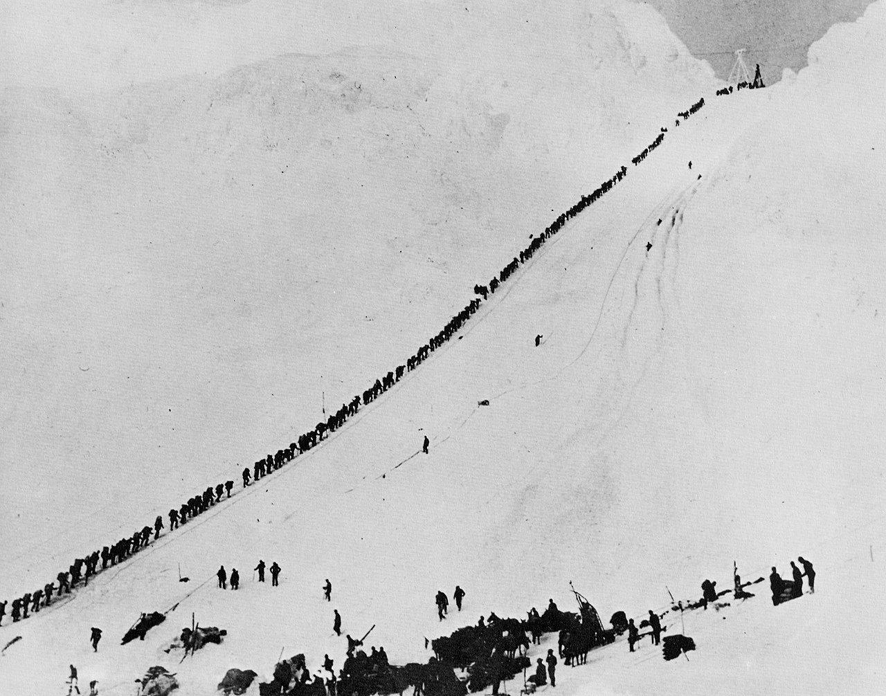
| İzah | Miners and prospectors climb the Chilkoot Trail during the Klondike Gold Rush. | |||
| Tarix | ||||
| Mənbə |
|
|||
| Müəllif | Hegg, E.A (1867-1948) | |||
This photo is of a cultural heritage site in Canada, number 9087
|

|
This is an image of a place or building that is listed on the National Register of Historic Places in the United States of America. Its reference number is 75002120 (Wikidata). |
| Object location | | View this and other nearby images on: OpenStreetMap |
|---|
Lisenziya
This Canadian work is in the public domain in Canada because its copyright has expired due to one of the following:
it was not subject to Crown copyright, and
You must also include a United States public domain tag to indicate why this work is in the public domain in the United States.
|
This work is in the public domain in the United States because it was published (or registered with the U.S. Copyright Office) before January 1, 1931.
Public domain works must be out of copyright in both the United States and in the source country of the work in order to be hosted on the Commons. If the work is not a U.S. work, the file must have an additional copyright tag indicating the copyright status in the source country.
Note: This tag should not be used for sound recordings. |
Faylın tarixçəsi
Faylın əvvəlki versiyasını görmək üçün gün/tarix bölməsindəki tarixlərə klikləyin.
| Tarix/Vaxt | Miniatür | Ölçülər | İstifadəçi | Şərh | |
|---|---|---|---|---|---|
| hal-hazırkı | 23:04, 17 avqust 2011 | | 2.536 × 1.994 (1.021 KB) | P199 | Reverted to larger file. |
| 22:12, 17 avqust 2011 |  | 763 × 600 (79 KB) | Soerenfm | Contrast and brightness enhanged | |
| 09:19, 19 iyun 2009 |  | 2.536 × 1.994 (1.021 KB) | LSDSL | http://images.zeno.org/Fotografien/I/big/PHO04536.jpg | |
| 10:02, 4 iyul 2005 |  | 640 × 477 (57 KB) | Adam~commonswiki | Miners and prospectors climb the Chilkoot Trail during the Klondike Gold Rush. From the Canadian National Archives [http://data2.collectionscanada.ca/ap/c/c005142.jpg] {{PD}} Category:History of Canada |
Faylın istifadəsi
Aşağıdakı səhifə bu faylı istifadə edir:
Faylın qlobal istifadəsi
Bu fayl aşağıdakı vikilərdə istifadə olunur:
- af.wikipedia.org layihəsində istifadəsi
- ar.wikipedia.org layihəsində istifadəsi
- azb.wikipedia.org layihəsində istifadəsi
- ca.wikipedia.org layihəsində istifadəsi
- ceb.wikipedia.org layihəsində istifadəsi
- cs.wikipedia.org layihəsində istifadəsi
- da.wikipedia.org layihəsində istifadəsi
- de.wikipedia.org layihəsində istifadəsi
- 17. Juli
- Goldrausch
- Goldrausch (Chaplin)
- Klondike Fields
- Geschichte Alaskas
- Yukon Quest
- Chilkoot Pass
- District of Alaska
- Liste der National Historic Sites of Canada in British Columbia
- Liste der National Historic Landmarks in Alaska
- Wikipedia:Hauptseite/Schon gewusst/Archiv/2009/01
- Wikipedia Diskussion:Hauptseite/Schon gewusst/Diskussionsarchiv/2009/Januar
- Klondike-Goldrausch
- Alaska-Kid
- Benutzer:Schneffe himself/2010
- Benutzer:JohaN/Yukon Quest
- Wikipedia:Auskunft/Archiv/2012/Woche 32
- Wikipedia Diskussion:Umfragen/Bezahlte Benutzer
- National Register of Historic Places in Alaska
- Eric A. Hegg
- el.wikipedia.org layihəsində istifadəsi
- en.wikipedia.org layihəsində istifadəsi
- Alaska
- Jack London
- Gold rush
- District of Alaska
- Chilkoot Trail
- Chilkoot Pass
- User:Mirv/images
- History of Alaska
- National Register of Historic Places listings in Alaska
- Harry Karstens
- List of National Historic Landmarks in Alaska
- Portal:Alaska
- National Register of Historic Places listings in Skagway, Alaska
- List of National Historic Sites of Canada in British Columbia
- Eric A. Hegg
- Timeline of the 19th century
- User:DoctorShmullus/sandbox
Bu faylın qlobal istifadəsinə baxın.